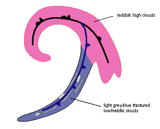
Cold Front In Cold Advection - Cloud Structure In Satellite Images
by ZAMG and FMI
CF´s in CA form mostly over the Atlantic, and are more common in the winter than during the summer season. The stage of CF´s in CA last generally 0,5-2 days. In the winter there are sometimes 3-4 day developments, however.
CF´s in CA are often old, dissolving kata-type fronts in occluded cyclones. The upper cloudiness is slight or nonexistent. Also in the earlier stages there is often a significant dark stripe behind the front due to the very cold dry air.
The appearance of CF in CA in different channels:
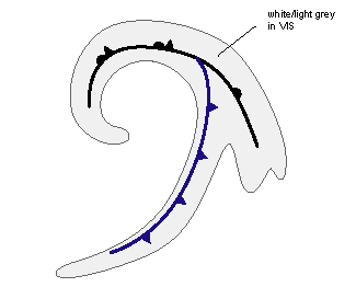
- In VIS images a white/light grey cloud band with some broken structure
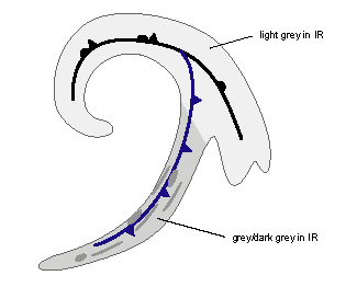
- In IR images grey, broken cloud band, which is clearly darker than other frontal parts (like warm front or occlusion) of the system
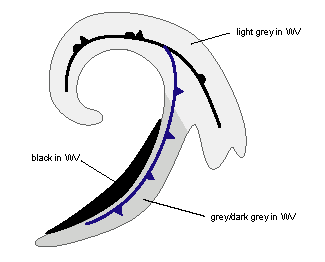
- In WV images a grey cloud band with often a black stripe behind it. In small and dissolving systems the black stripe is missing. Also in some cases other systems like jet clouds or an upper wave can hide the black stripe. Generally in the end of the CF in CA stage the dark stripes weaken and disappear.
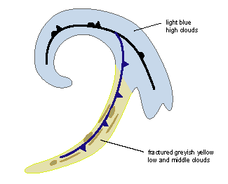
- In the combination (HRVis;HRVis;IR10.8i) greyish yellow cloud band with some fractured fibres of light blue cirrus
- In convection product (WV6.2-WV7.3;IR3.9-IR10.8,NIR1.6-VIS0.8) the front looks almost nonexistent in the area of warm advection, with only some grey-blue patchy cloudiness
|
|
|
|
|
|
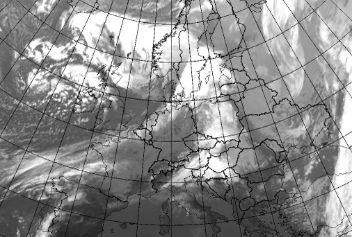
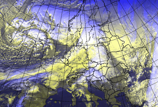
20 January 2007/12.00 UTC - Meteosat 8 IR10.8 image
|
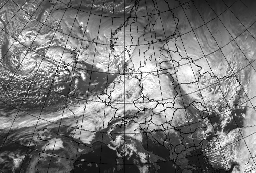
20 January 2007/12.00 UTC - Meteosat 8 VIS0.6 image
|
|
|
|
|
|
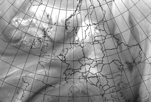
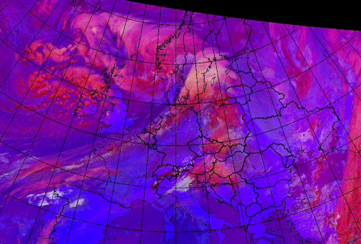
20 January 2007/12.00 UTC - Meteosat 8 WV6.2 image
|
20 January 2007/12.00 UTC - Meteosat 8 (hrvis,hrvis,IR10.8i) image
|
|
20 January 2007/12.00 UTC - Meteosat 8 (WV6.2-WV7.3;IR3.9-IR10.8,NIR1.6-VIS0.8) image
|
|
|
- Along the front there can be several types of Cold Fronts present, that is CF, CF in CA and CF in WA.
- In the earlier stages there might still be some upper cloudiness connected to the front.
- Quite often (in over 70% of the cases) some other upper cloudiness overruns CF in CA: most common is Jet Fibres, the other possibility is an Upper Wave. This might make the images look like an ordinary Cold Front, and hide the black stripe behind the CF in CA.
- CF in CA can change back into CF or even into CF in WA before it is dissolved.
- Sometimes in the north CF in CA can be found already in a wave before the occlusion stadium. These fronts look like conventional Cold Fronts in the beginning, but the cloudiness reduces rapidly.
- The dark stripes are clear only in the beginning of the development, afterwards they grow lighter and smoother.
-
The last stage of CF´s in CA can be:
- most often a common CF, after the cold advection has reduced, or warm advection from a WF or WCB is effecting it
- CF in CA can also dissolve in itself when the cyclone is very old and there are no other features nearby having any influence
- a Split Front, although this is rare.

