Cold Front - Special Investigation: Cold Front/Occlusion
by ZAMG
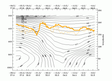
There is group of Cold Front cloud bands that deviates from the ideal configurations almost only in the configuration of the isentropes: instead of the downward inclined zone of high gradients of isentrops a configuration typical for an Occlusion cloud band exists namely an isentropic trough (see
Occlusion: Warm Conveyor Belt Type - Typical appearance in vertical cross section
).
|
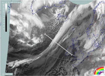
21 November 1999/00.00 UTC - Meteosat IR image; position of vertical cross section indicated
|
21 November 1999/00.00 UTC - Vertical cross section; black: isentropes (ThetaE), orange thin: IR pixel values, orange thick: WV pixel
values
|
|
|
|
Although the information from the isentropes in the vertical cross section is rather striking many other indicators support the physical status of a Cold Front instead of an Occlusion:
- the synoptic scale size of the cloud band and the history in the satellite images
- the distribution of the frontal parameters like TFP, thickness and temperature advection.
|
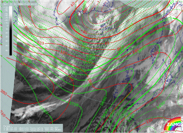
21 November 1999/00.00 UTC - Meteosat IR image; green: height contours 500 hPa, red: height contours
1000 hPa
|
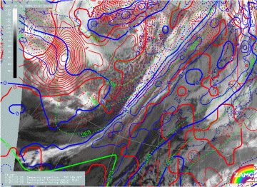
21 November 1999/00.00 UTC - Meteosat IR image; green: thickness, blue: thermal front parameter, red:
temperature advection 700 hPa
|
|
|
|
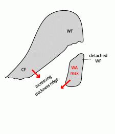
A detailed investigation of 20 cases identified within one year of Cold Front cases supported the diagnosis of Cold Front. The existence of an Occlusion - like appearance of isentropes comes from a distinct thickness ridge. But this ridge is not the consequence of an Occlusion process (see
Occlusion: Warm Conveyor Belt Type - Meteorological physical background
) but the result of:
- the approach of the Cold Front to a rather stationary Baroclinic Boundary
- the merging with other CMs like for instance a Detached Warm Front.
Both process lead to pronounced thickness ridges in front of the Cold Front cloud band and therefore show up as isentropic trough in the cross sections.