Cumulonimbus Cluster - Cloud Structure In Satellite Images
by KNMI and DHMZ
- Cb Clusters appear as a group of relatively large separate cells in satellite images.
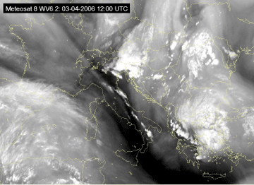
- In the IR, VIS and WV images Cb Clusters are generally white, indicating thick, multi-level clouds, but in the initial phase of development separate grey cells are visible, indicating relatively low tops.
- Very often the surrounding atmosphere is characterized by the development of other convective cells.
- In well-developed phase, cirrus shields of single CB cells merge, leading to a very white smooth cloud shield in the IR and a somewhat transparent appearance in the VIS image.
|
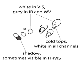
Cb Cluster in Developing Stage
|
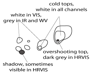
Cb Cluster in Mature Stage
|
|
|
|
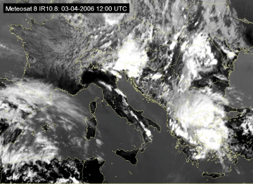
03 April 2006/12.00 UTC - Meteosat 8 IR 10.8 image
|
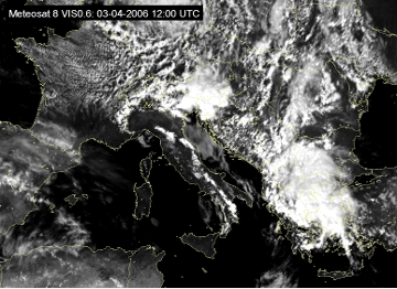
03 April 2006/12.00 UTC - Meteosat 8 VIS 0.6 image
|
|
|
|
|
|
03 April 2006/12.00 UTC - Meteosat 8 WV 6.2 image
|
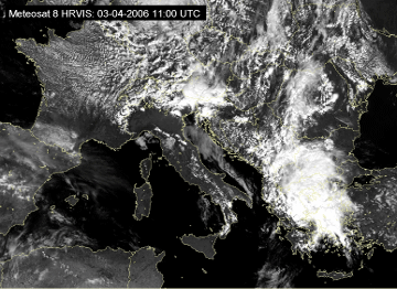
Appearance in Meteosat 8 HRVIS and RGB composite imagery
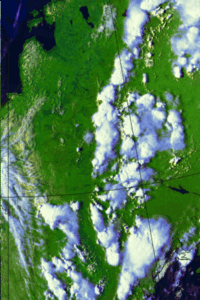
High resolution of Meteosat 8 HRVIS images makes smaller fine-scale cloud structures more distinct. The process of Cb Clusters developing into MCS over Slovenia and southern Austria can be nicely followed while multi-cell structure of the bigger system is much better visible.|
03 April 2006/11.00 UTC - Meteosat 8 HRVIS image
|
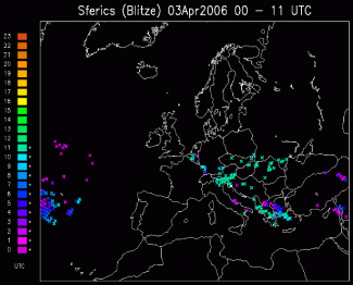
03 April 2006/11.00 UTC - Lightning detection
|
|
|
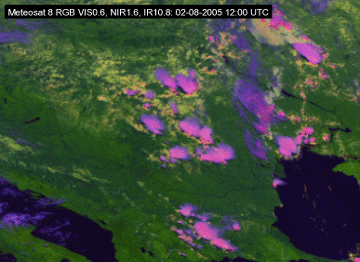
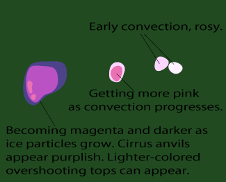
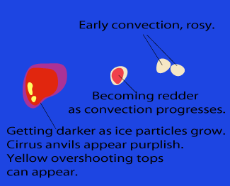
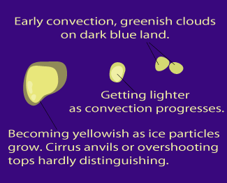
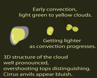
To observe daytime convection, Microphysical RGB VIS0.6, NIR1.6, IR10.8i is recommended. In this type of image, already at a very early stage the convection appears white to light pinkish, getting more pink as convection progresses; first icing can be spotted as magenta cores turning darker to become purple as ice particles grow.
|
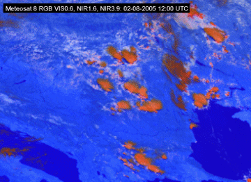
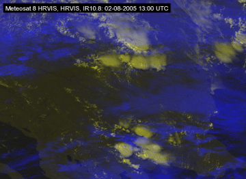
02 August 2006/12.00 UTC - Meteosat 8 RGB (VIS0.6, NIR1.6 and IR10.8i) image
|
Cb Cluster as it appears in RGB VIS0.6, NIR1.6, IR10.8i imagery
|
|
|
|
02 August 2006/12.00 UTC - Meteosat 8 RGB (VIS0.6, NIR1.6 and NIR3.9) image
|
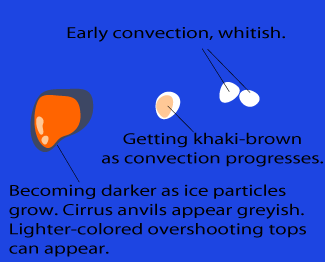
Cb Cluster as it appears in RGB VIS0.6, NIR1.6, NIR3.9 imagery
|
|
|
|
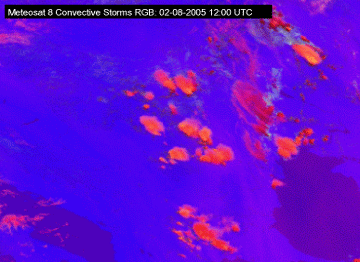
02 August 2005/12.00 UTC - Meteosat 8 Convective Storms RGB (WV6.2 -WV7.3, NIR3.9 -IR10.8 and NIR1.6 -VIS0.6) image
|
Cb Cluster as it appears in Convective Storms RGB
|
|
|
|
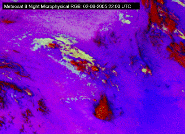
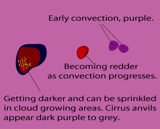
02 August 2005/22.00 UTC - Meteosat 8 Night Microphysical RGB (IR12.0-IR10.8, IR10.8-NIR3.9 and IR10.8) image
|
Cb Cluster as it appears in Night Microphysical RGB
|
|
|
|
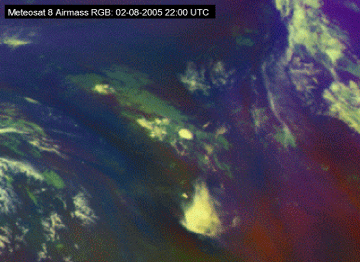
02 August 2005/22.00 UTC - Meteosat 8 Airmass RGB (WV6.2-WV7.3, IR9.7-IR10.8 and WV6.2i) image
|
Cb Cluster as it appears in Airmass RGB
|
|
|
|
02 August 2006/22.00 UTC - Meteosat 8 High resolution RGB (HRVIS, HRVIS and IR10.8i) image
|
Cb Cluster as it appears in High resolution RGB
|
|
|
Appearance in AVHRR imagery
- Cb Clusters are easy to detect with AVHRR images, as the better resolution helps to see the individual cells better.
- Combination image 124 is very powerful in showing these cells. As the cells grow and the cirrus anvils spread, the intensely white cores stay identifiable within the bluish cirrus filaments.
- 124 image combinations usually give a better visual appearance than daytime 345 image combinations due to better contrast between convective areas within the cloud and surrounding cirrus clouds. Cb Clusters are also very striking in 345 image combinations due to strong contrast between white clouds and dark red cloud-free land areas.
|
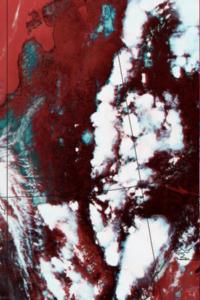
10 June 1999/15.01 UTC - NOAA RGB (channel 1, 2 and 4) image
|
10 June 1999/15.01 UTC - NOAA RGB (channel 3, 4 and 5) image
|
|
|
|
|
|
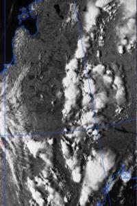
10 June 1999/15.01 UTC - NOAA CH2 image
|
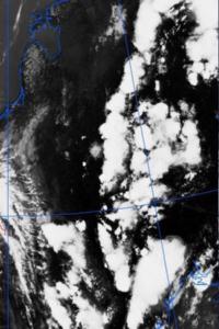
10 June 1999/15.01 UTC - NOAA CH4 image
|
The Cb cells can easily be identified as being mainly separate clouds systems. Some merging of the clouds is taking place just northwest of the Black Sea. The NOAA 124 images show the thick Cb cores within the surrounding bluish cirrus anvils. At the same time the Cb cells in the NOAA 345 images are very distinct white in otherwise reddish surroundings, but the details are partly lost due to the saturated whiteness everywhere within the cells.
Similar differences can also be seen in the individual VIS and IR images.

