Convective Cloud Features In Typical Synoptic Environments: Enhancement Of Convection By PV - Cloud Structure In Satellite Images
by KNMI and DHMZ
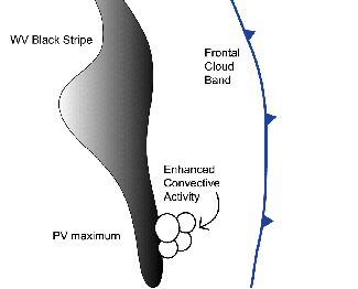
Potential Vorticity (PV) often plays an important role in the enhancement of convection either within or outside frontal zones.
Due to the fact that potential vorticity maxima at a certain level in the atmosphere represent the intrusion of dry air from the upper tropospheric or
stratospheric levels into the lower troposphere, the best images to follow the processes connected to the PV are the WV images.
In WV imagery, convection is sometimes considerably enhanced just ahead of narrow elongated black stripes, and appears as developing white spots or marks.
Schematic of a black area in the WV image and the triggering of convectivity at the front side
04 August 2006/00.00 UTC - Meteosat 8 WV6.2 image
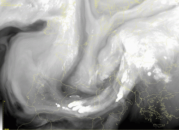
The Meteosat 8 WV channel 6.2 µm images show convective development southeast of Spain, associated with the WV dark stripe stretching from N. France towards the northern Spain. Convection occurs just next to the darkest area in the WV image, at the rear side of the frontal zone.
Appearance in the AIRMASS RGB composite images
Apart from the single WV channel, the effects of the potential vorticity are even clearer in the Airmass RGB image, due to the fact that the combination of channels in the Airmass RGB clearly points out the regions where the intrusion of dry air from the upper levels takes place.
04 August 2006/00.00 UTC - Meteosat 8 Airmass RGB image
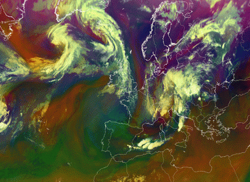
Reddish stripe from the north over France entering Mediterranean near the Baleares is connected to the dry air subsiding from the upper levels and therefore with high PV values. Convective clouds develop on the edge at the frontage of the reddish stripe.

