Convective Cloud Features In Typical Synoptic Environments: Enhancement Of Convection By PV - Meteorological Physical Background
by KNMI and DHMZ
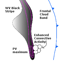
If stratospheric air is penetrating into the troposphere, a PV anomaly associated with a vorticity maximum will be observed. The reason for this is that the static stability in the troposphere is significantly lower than in the stratosphere. PV maximum is associated with cyclonic flow and high static stability. The relative vorticity and static stability anomaly on isentropic surfaces are therefore positively correlated. Distortions in the tropopause characterised by tongues of anomalously high PV are formed through the action of the large-scale deformation field, extending towards the equator. Some parts of these tongues may be stretched into long filaments, or roll up to form the isolated structures called the "cut-off" cyclones. Filamentary structures are mostly associated with stratosphere-troposphere exchange processes. In the troposphere, the distance between isentropic surfaces is much larger than in the stratosphere. As a result, relative vorticity will increase. (see Additional Parameters Indicative Of The Diagnosis Of Cloudiness: Potential Vorticity ). In the case of a propagation of the PV anomaly, there will be advection of positive vorticity ahead of the anomaly and advection of negative vorticity behind it. The propagation of PV anomaly is often associated with westerly current transport. The advection of positive vorticity, if increasing with height, causes divergence in the upper troposphere and, as a consequence, upward motion. On the other hand, convergence behind the anomaly causes sinking motion.
Although potential vorticity (PV) and vorticity advection (VA) are strongly connected, the use of PV as a key parameter, together with the WV image, is often more illustrative than using PVA patterns alone.
When a PV anomaly approaches an area of moist and potentially unstable air, strong convection is initiated and convection systems such as EC, Comma, Cb Clusters or MCS can develop. Additionally decaying systems can make intensify through this process. Locations favourable for these phenomena are in cold air to the rear of frontal cloud bands.
|
Schematic of the typical distribution of PV and the related WV image
|
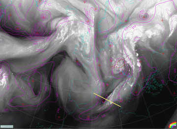
01 November 2001/06.00 UTC - Meteosat WV image; red: potential vorticity 318K; position of vertical cross
section indicated
|
|
|
|
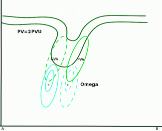
Schematic of PV anomalies in the upper troposphere and the connected vorticity advection and omega
patterns
|
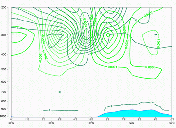
01 November 2001/06.00 UTC - Vertical cross section; black: potential vorticity, magenta: vorticity
advection - PVA, cyan: vorticity advection - NVA
|
|
|
The cross section shows a distinct PV anomaly, with the PV-2 unit protruding to 400 hPa. A distinct maximum of PVA can be found along the forward edge of the PV anomaly, causing upward motion and development of the Cb Clusters.


