Convective Cloud Features In Typical Synoptic Environments: At The Leading Edge Of Frontal Cloud Bands - Cloud Structure In Satellite Images

by ZAMG


An area with a high probability for the initiation of convection is the leading edge of Cold Front cloud bands. The initiation of convection only happens where there is an appropriate tropospheric structure (see Meteorological physical background and Key parameters).
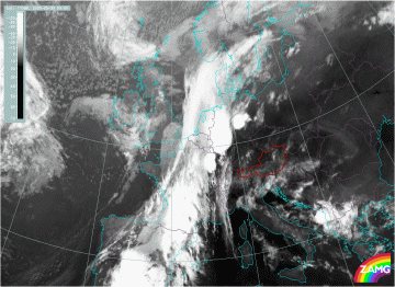
30 May 2005/00.00 UTC - Meteosat 8 IR10.8 image
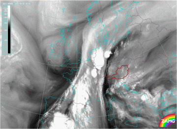
30 May 2005/00.00 UTC - Meteosat 8 WV6.2 image
The images above show a typical situation where convective cells have developed within a frontal zone. A series of very well developed MCSs can be observed from North Western Germany across the Elzas to Southern France and Andalusia. In the IR10.8 image (left) the cells are generally much brighter than the surroundings. The dark stripes in the WV image (right) near the cells are typical features associated with MCSs.

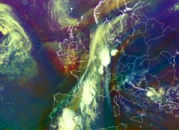
An artificial composite of the infrared and water vapour channels of Meteosat 8 is provided by the Airmass-RGB. The Airmass-RGB consists of the WV6.2 - WV7.3 Brightness Temperature Difference (BTD, on red), the IR9.7 - IR10.8 BTD (on green) and the WV6.2 channel (on blue). A particular feature of this RGB is that dry descending stratospheric air is marked by a reddish colour. Some other features recognizable in this RGB can be found here .

30 May 2005/00.00 UTC - Meteosat 8 Airmass-RGB image
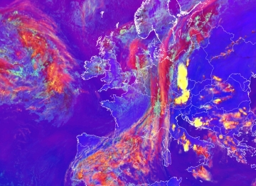
30 May 2005/12.00 UTC - Meteosat 8 Severe Convection-RGB image
A second RGB useful to monitor convection is the Severe Convection RGB. An example of this RGB is shown in the image above right. The RGB is build up of the composite of the BTD of WV6.2-WV7.3 on red, the BTD of IR3.9-IR10.8 on green and the BTD of NIR1.6-VIS0.6 on blue. In the image all the cells can be recognised easily: a large bright yellow cell at the leading edge of the front over Austria and Czech Republic and a more orange cells over Eastern Europe.

The colours of these cells explain the physical content. Whereas the yellow cell at the leading edge of the front is mainly consisting of very small ice particles, the eastern cell has further developed and already consists of larger ice particles. More on the different colours observed in this Severe convection RGB can be found here .


Menu Of Convective Cloud Features In Typical Synoptic Environments: At The Leading Edge Of Frontal Cloud Bands
Meteorological Physical Background