Convective Cloud Features In Typical Synoptic Environments: Fair Weather Conditions - Meteorological Physical Background
by ZAMG
- Associated with fronts or frontal zones
- Under "fair weather" conditions
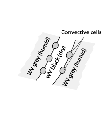
The preferred area for the first appearance of DMC, associated with the transition zone between moist and dry upper air, is called "WV - Boundary".
The physics behind convective development at a WV-Boundary can be best described from the hydrostatic point of view.
Convective activity can appear in different synoptic environments:
- Fronts or Convergence Lines associated with upper level troughs or lows and the intrusion of cold dry air from higher levels of the troposphere or even the stratosphere (mostly seen as a dark zone in WV images) behind a Cold Front.
- At the leading edge of frontal cloud bands. Advection of cold and dry air at higher levels overrunning a frontal cloud band can also be observed as a dark zone in the WV image. This mechanism can cause severe storms for instance within prefrontal squall lines.
All these mechanisms are well indicated by typical parameters used in numerical weather prediction models, where the synoptic scale environment for convection can also be easily determined.
The type of deep moist convection under discussion is clearly not associated with a frontal cloudband and frontal dynamics. The typical synoptic environment is an isobaric ridge at 500 hPa and a ridge or a maximum of the thickness (500 - 1000 hPa). Because of the absence of a frontal cloudband or any extensive cloud area this type of convection is called convection under "fair weather conditions".
In numerous "fair weather" cases over Europe cells have been investigated with respect to their first appearance in WV imagery. However, shallow convection often occurs over mountainous terrain (over 400 meters above MSL) and can be found in visible and infra red images even before their appearance in the WV imagery:
- The first appearance of deep convection happens in 66% of the investigated cases, at the WV Boundaries.
- Convective cells within a dry or humid area of a WV structure generally appear somewhat later in time.
- About 22% of the cells appear first at weaker boundaries within a more humid area.
- About 12% of the cells appear first within a dry area.
- Nearly all cells seen first within a humid or dry area grow above mountainous terrain higher than 400m MSL which likely indicates orographic triggering.
- 24 % of all cells appearing first at a WV - Boundary are not connected with orography.
- There is no indication of the exact location where DMC appears at the WV - Boundary.
This suggests that the development of deep convection can also depend on the special physical environment at the WV - Boundaries.
Possible reasons for the preferred location of deep convection at the WV - Boundary
DMC depends on the available moisture, conditional instability and a source of lift. This lift needs to be sufficient in order to move an air parcel to its level of free convection, initiating the process of deep convection.
Dynamic initiation
Some of the WV structures resemble cyclonic eddies associated with vorticity and vorticity advection. However, DMC under "fair weather" does not show any remarkable cyclonic vorticity. Even if numerical models (global or LAM) would be wrong, or would not resolve the structures in this area (WV features are of a rather extended scale) this would not explain the first appearance of deep convection at the narrow zone of the WV - Boundaries.Here, processes at a much smaller scale, namely the narrow transition zone between dry and moist areas in water vapour imagery, seem to be of importance.
The following aspects have been observed:
- Convection under "fair weather" shows a distinct diurnal cycle of development and decay.
- The cells of DMC are initiated in the lower levels of the troposphere.
- Deep convection develops and decays much faster than the WV structures they are embedded in.
Incoming solar radiation and diabatic heating
One source of initiation of convection is the diabatic heating of the surface and adjacent air layers by incoming solar radiation during the daytime. An absolutely unstable shallow layer near the surface will develop, where spontaneous convective overturning becomes likely. If enough lifting energy is provided the rising air parcel might reach condensation leading to strong deep moist convection at the level of free convection in the case of conditional instability. If the lifted parcel starts from higher surfaces, e.g. mountain slopes, less energy is needed to reach the level of free convection. This implies that shallow convection will start earlier from elevated surfaces.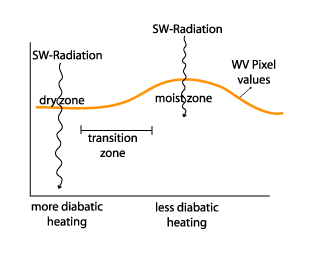
The vertical stratification of the air column
The area under consideration is a widespread conditionally unstable region in the low and middle troposphere, which can also be seen in the vertical cross sections (see schematic below).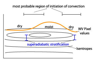
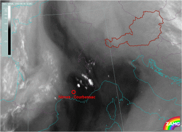
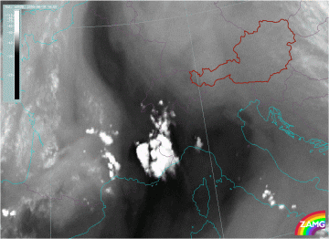
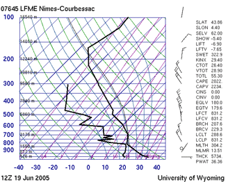
This can be demonstrated with the example from 19 June 2005. The radio sonde station in Nimes-Courbessac, France is indicated in the WV 6.2 image by the red circle. This station measurement is closest to the development, both in distance and time of the day. The image below right, shows the situation when the development of the cell is completed.
|
19 June 2005/12.00 - Meteosat 8 WV 6.2 image; location of radiosonde stations indicated
|
19 June 2005/14.00 UTC - Meteosat 8 WV 6.2 image
|
|
|
Horizontal gradients in potential instability will develop in areas with a homogeneous distribution of humidity at low levels having inhomogeneous distributions of humidity above (shown in the WV imagery), (see Basics - Numerical parameters for small scale convective cloud systems: Convection and instability). Higher potential instability is achieved when there is a higher vertical gradient of humidity. Consequently between these two regions there is a horizontal gradient in potential instability which corresponds to the WV Boundary.
When a deep convective cell grows, the strong upward motion will cause turbulent entrainment at the boundary of the cloud. The evaporation of cloud droplets and the resulting negative buoyancy counteracts convection. When DMC grows into the dry upper layer, there would be a stronger effect of entrainment than in a humid upper layer. The first cells at the WV Boundary tend to grow in the humid region of the boundary. Consequently a certain supply of humidity at middle and upper levels seems to be favourable for the further growth of cells as soon as shallow convection changes into deep convection.
It can be concluded that because of the small scale of the phenomena, observations from soundings have limited use. Therefore only differences between areas with dry and humid upper layers, seen in WV Boundary regions, are significant for DMC development.
In the dry zone of the WV Boundary, surface heating is stronger than under the humid region. Therefore DMC might be initiated earlier and the water vapour supply above is still sufficient. Although potential instability is higher within the dark area of the WV image, the missing upper level humidity supply restricts growth of deep convection. It seems that the combination of these effects is necessary for DMC development in the transition area of the WV Boundary.


