Occlusion: Cold Conveyor Belt Type - Meteorological Physical Background
by ZAMG and KNMI
The classical Norwegian model
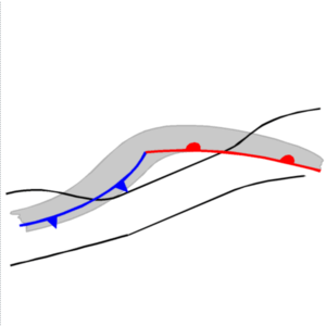
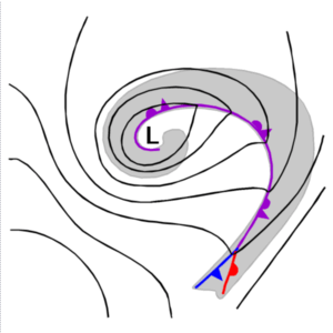
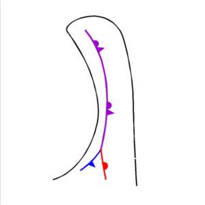
The classical development of an Occlusion is described in the well-known polar front theory after Bergeron as a development from a Wave stage (see Wave) with a well developed Cold Front (see Cold Front, Cold Front In Cold Advection, Cold Front In Warm Advection, Split Front and Arctic Cold Front) and Warm Front (see Warm Front Band, Warm Front Shield and Detached Warm Front). The basic idea is that the Cold Front moves faster than the Warm Front. Therefore the warm sector continously becomes more narrow until finally the Cold Front overtakes the Warm Front completely, thereby lifting the warm air. This is the typical situation for the Occlusion band which turns cyclonically around the core of the cyclone.
|
|
|
|
- If the air situated in front of the Warm Front has about the same temperature as the air situated behind, the temperature gradient dissolves during the process of the Occlusion. In this case the Occlusion is characterized only by a line of cyclonic shear and convergence which can be found vertically below the merging point of both fronts.
- If the air situated in front of the Warm Front is colder than the air behind, a so-called Warm Front Occlusion develops which has a forward inclined frontal surface.
- If the air situated in front of the Warm Front is warmer than the air behind, a so-called Cold Front Occlusion develops which has a backward inclined frontal surface.
|
Warm Occlusion
|
Cold Occlusion
|
|
|
Deviations between cloud configurations in satellite images and the classical Norwegian model
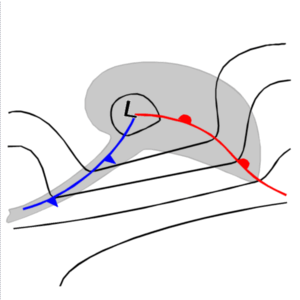
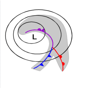
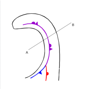
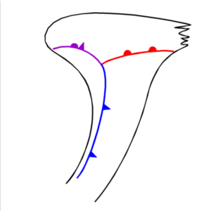
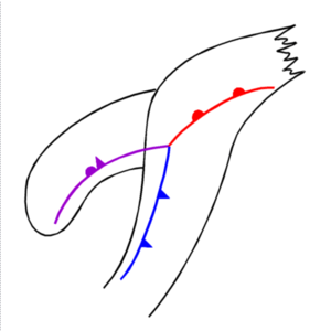
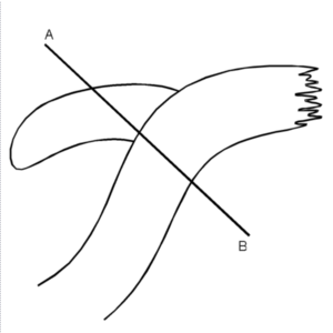
Very soon after the use and study of satellite images it became clear that this idealized theory cannot be observed in every step and detail in reality. In particular, the overtaking of the Warm Front by the Cold Front with very narrow warm sectors can never be seen (left schematic). Instead of this a mergence of Cold and Warm Front cloudiness in the centre of the surface low takes place followed by a westward extension of the Occlusion cloud spiral, while the Warm Front cloudiness becomes shorter (right schematic).
|
|
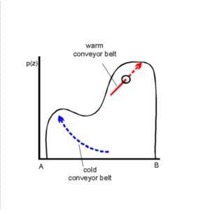
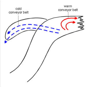
Conveyor Belt model
This theory is not an independent new model, but allows a different insight into the same phenomena of the Occlusion process. It shows a much bigger variety of development possibilities and clearly indicates that the Occlusion development described by the Norwegian model represents only a special case.The conveyor belt theory for the Cold Front deals predominantly with two relative streams: the warm conveyor belt and the dry intrusion. The warm front deals predominantly with the relative streams of the warm conveyor belt and the cold conveyor belt. For the Occlusion all three conveyor belts are relevant:
- The warm conveyor belt is a rising relative stream from south, south-eastern directions turning to north, north-eastern directions; it transports warm and moist air.
- The dry intrusion is a sinking relative stream from north-west to south-east, splitting into two
branches: a further sinking one to the south-west and a rising one to the north-east.
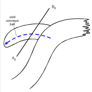
The cold conveyor belt is a rising relative stream from east, south-east which is initially below the warm conveyor belt, but then emerges from below and extends to northern directions.
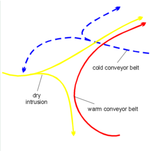
The latter form of the Occlusion can much more often be observed in the satellite image than the Warm Conveyor Belt form of the Occlusion (see Occlusion: Warm Conveyor Belt Type ).It can only be explained with the help of the conveyor belt theory.
The dominant streams in this case are the cold conveyor belt and the warm conveyor belt.
|
|
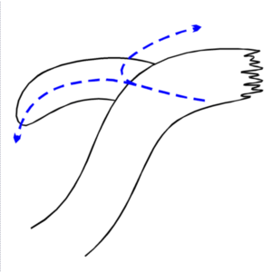
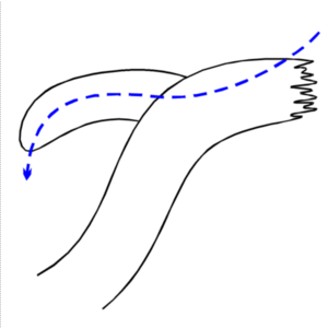
In literature different configurations of the cold conveyor belt are mentioned:
|
|
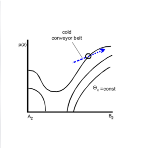
- The lower levels of the troposphere are characterized by an ascending cold conveyor belt with two sub-types
according to its orientation:
- In some cases a splitting of the stream lines within the area of the point of the Occlusion can be observed. This type exists when the frontal surface reaches the ground.
- In other cases the cold conveyor belt first follows the Occlusion band from north, north-east to south-west.
- Both sub-types show the rising and cyclonically curved cold conveyor belts, which are responsible for the
development of the lower cloud spiral. Not as easy to explain is the splitting of the relative stream in one of
the schematics above. There are two possible obvious explanations:
- It is a branch of a splitting cold conveyor belt similar to the classical description.
- The eastern anticyclonic branch represents the lowest parts of the warm conveyor belt, while the western cyclonic branch represents the cold conveyor belt.
- At the present time intensive investigations favour the second explanation. Reasons for this are:
- The fact that on the isentropic surfaces of only one Kelvin distance a smooth growth of the eastern branch into the synoptic scale warm conveyor belt can be observed.
- The good agreement between Warm Front cloudiness and relative streams there.
- Reasons against this explanation come from the fact that the relative stream of the cold conveyor belt branch seems to arise from an area to the south of the warm conveyor belt. The key for the explanation can be found in an intensive inspection of vertical cross sections.
|
|

|
|
|
|
|
|
|
|
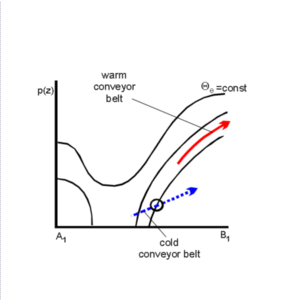
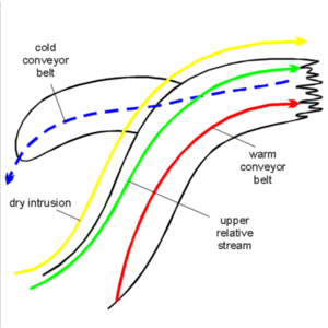
- The mid- and upper levels of the troposphere are characterized by three different conveyor belts. The moist air is within the warm conveyor belt as well as within the upper relative stream at the anticyclonic side of the jet, and the dry air is within the dry intrusion at the cyclonic side of the jet.
- The warm conveyor belt and the upper relative stream are parallel to the cloud band of the Cold Front, and turn then anticyclonically parallel to the cloud band of the Warm Front (this is a difference from the warm conveyor belt type of Occlusion (see Occlusion: Warm Conveyor Belt Type ).
- The dry relative stream of the dry intrusion crosses the cloud spiral at the cyclonic side of the jet, which is the area of the Occlusion spiral. This situation restricts the development of higher cloudiness there and leads to the typical appearance in the satellite image (see Cloud structure in satellite image ). Further westwards the tops of the cloud spiral are becoming colder again as the cold conveyor belt ascends there.
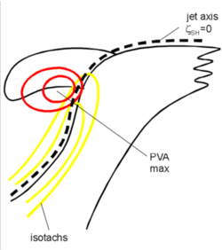
- Such a distribution of conveyor belts can also be seen as a consequence of the jet above:
- The jet is parallel to the rear cloud edge of the cloud band of the Cold Front.
- Often a jet streak exists with the PVA maximum within the left exit region (see Front Intensification By Jet Crossing ) superimposed on the Occlusion spiral (see Cloud structure in satellite image ).
|
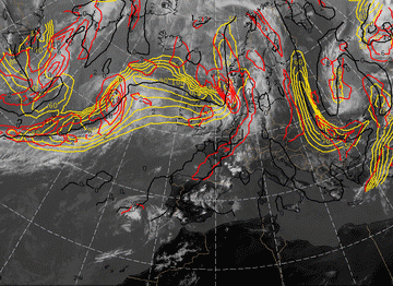
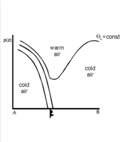
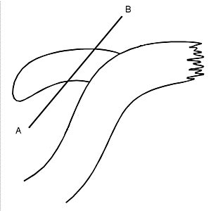
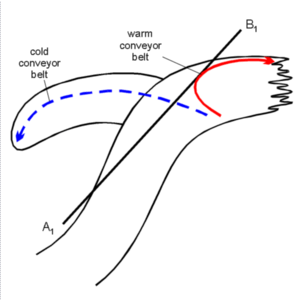
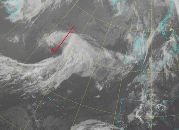
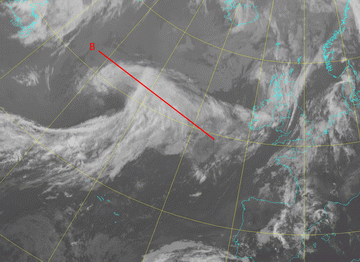
21 June 2005/00.00 UTC - Meteosat 8 IR 10.8 image; position of vertical cross section A indicated
|
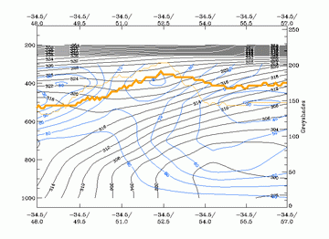
21 June 2005/00.00 UTC - Vertical cross section A; black: isentropes (ThetaE), blue: relative humidity, orange
thin: IR pixel values, orange thick: WV pixel values
|
|
|
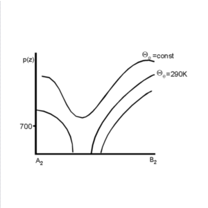
The relative streams cut the cross section perpendicularly on the isentropic surface of 314 K at a height between 650 and 850 hPa.
|
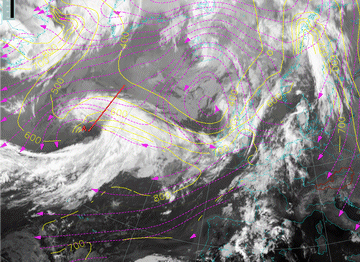
21 June 2005/00.00 UTC - Meteosat IR image; magenta: relative streams 314K - system velocity: 239°
18 m/s, yellow: isobars 328K; position of vertical cross section A indicated
|
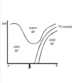
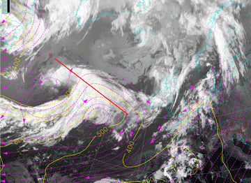
21 June 2005/00.00 UTC - Meteosat 8 IR 10.8 image; position of vertical cross section B indicated
|
|
|
|
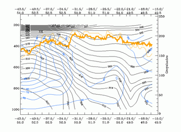
21 June 2005/00.00 UTC - Vertical cross section; black: isentropes (ThetaE), blue: relative humidity, orange
thin: IR pixel values, orange thick: WV pixel values
|
21 June 2005/00.00 UTC - Meteosat IR image (ZAMG); magenta: relative streams 328K - system velocity: 239°
18 m/s, yellow: isobars 328K, position of vertical cross section B indicated
|
|
|