Cold Air Development - Meteorological Physical Background
by ZAMG and KNMI
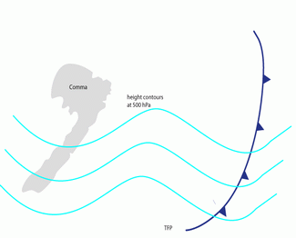
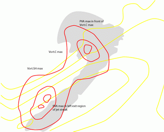
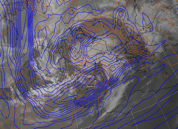
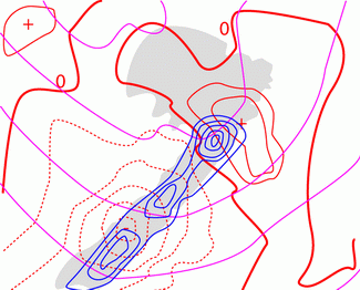
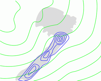
- Upper level forcing represented by PVA maxima in connection with both:
- a propagating and deepening upper level trough
- a left exit region of a moving jet streak
- Considerable unstable conditions in the middle troposphere below the Comma.
- Pre-existing baroclinicity within the cold air close to and south of the Comma tail.
|
|
|
|
|
|
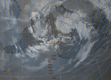
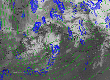
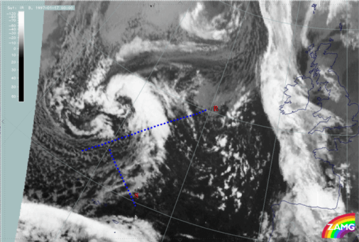
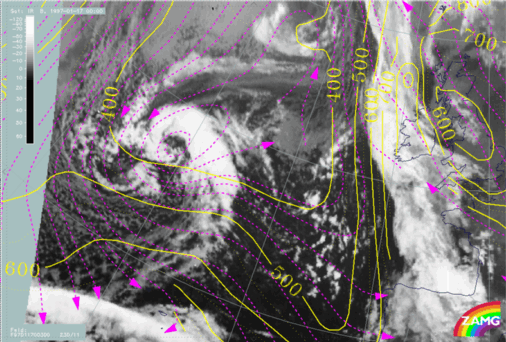
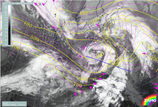
06 March 2009/06.00 UTC - Meteosat 8 IR 10.8 image; cyan: height contours 500 hPa
|
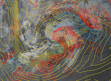
06 March 2009/06.00 UTC - Meteosat 8 IR 10.8 image; yellow: isotachs 300 hPa, red: vorticity advection 300 hPa
|
|
|
|
|
|
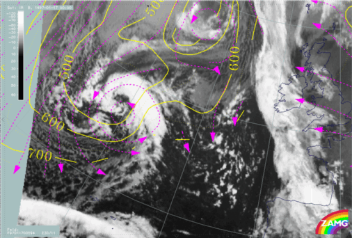
06 March 2009/06.00 UTC - Meteosat IR image; blue: shear vorticity 300 hPa, brown: curvature vorticity 300 hPa
|
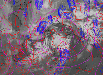
As described in the previous chapter (see Cloud structure in satellite image ) in the initial stage mostly an organized southward continuation of the Comma tail in the low cloud area can be observed. This seems to represent the baroclinic zone which is confirmed by the existence of a weak surface trough with a front-like wind shift, a weak TFP and in some cases a zero line of temperature advection. The latter does not indicate strong temperature differences. In contrast to Cold Fronts these parameters do not mark a change to a different air mass, but only small drops in temperature and dew point.
During the Cold Air Development the baroclinic zone intensifies, which can be seen as increasing cloud as well as in a strengthening of all parameters mentioned before.
|
|
|
|
|
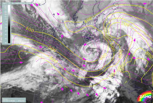
06 March 2009/00.00 UTC - Meteosat 9 IR10.8; magenta: height contours 1000 hPa, red: temperature advection 500/1000 hPa, blue: thermal front
parameter 500/850 hPa
|
06 March 2009/00.00 UTC - Meteosat 9 IR10.8; blue: thermal front parameter 850 hPa, green: thickness 500/1000 hPa
|
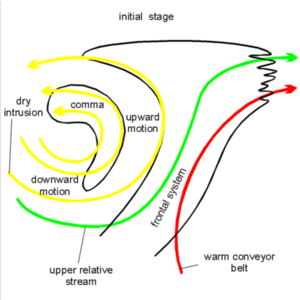
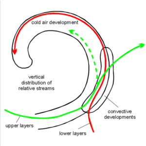
- In the initial stage, the Comma stage, a vortex structure can be identified within the huge area of the dry intrusion. This vortex shows
strong rising in the area of the Comma cloudiness within the middle and upper troposphere as well as strong sinking behind. In most cases
there are very unstable conditions in the low and middle troposphere below the Comma feature. Consequently both the convection and the
rising relative streams contribute to the Comma cloudiness.
As long as the prime frontal system is close to the Comma the typical frontal relative streams can be observed within the frontal cloud system.
It is not clear if the structure of the relative streams in the area of the Comma can be called a sub-structure of a broad dry intrusion area, or if it is a different relative stream. According to common knowledge the dry intrusion originates in the north-west and is sinking downward to the south-east. Relative streams in the Comma vortex originate in the south-east.
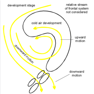
- In the development stage of the Cold Air Development, which is mainly charcterized by a strengthening of the Baroclinic Boundary in the southern part, the vortex structure of the Comma head can still be identified. A relative stream from a northern to south-eastern direction crosses the area of the low cloud top Baroclinic Boundary in a sinking manner. This is in accordance with the low cloud tops there, but contradicts the fact that at this stage of development an intensification of the cloudiness has already taken place. It might be possible that in the lowest layers frontal conditions in the relative streams exist as well, but this is difficult to compute.
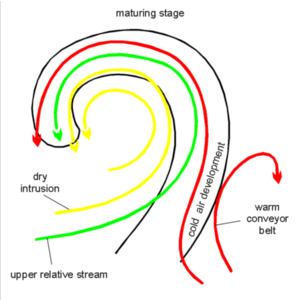
- In the mature stage the vortex pattern still exists but a warm conveyor celt, or at least a Warm Conveyor Belt - like relative stream,
develops within the increased Baroclinic Boundary. Within this area front or front-like conditions of the relative streams support the Cold
Air Development.
One main difference to classical frontal conditions can be found in the orientation of the stream lines of the warm conveyor celt which turn into the direction of the Comma head instead of indicating the Warm Front. This can be regarded as a sign that no Warm Front development has taken place or is going on, which is a main difference between the classical polar front developments and Cold Air Developments (see Warm Front Band , Warm Front Shield and Detached Warm Front ).
At this stage a situation often develops in the area of the Cold Air Development of the rising warm conveyor belt in the leading part of the Baroclinic Boundary, which is overrun by a relative stream from behind. Consequently a typical vertical stratification of different air masses develops, leading to conditional unstable conditions and convective developments (see Cloud structure in satellite image and Weather events ).
|
|
|
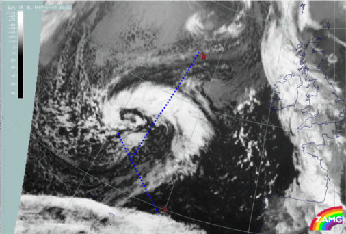
17 January 1997/00.00 UTC - Meteosat IR image; position of vertical cross sections indicated
|
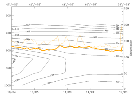
17 January 1997/00.00 UTC - Vertical cross section R; black: isentropes (ThetaE), orange thin: IR pixel values, orange thick: WV pixel values
|
|

|
|
|
|
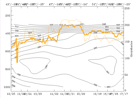
17 January 1997/00.00 UTC - Vertical cross section S; black: isentropes (ThetaE), orange thin: IR pixel values, orange thick: WV pixel values
|
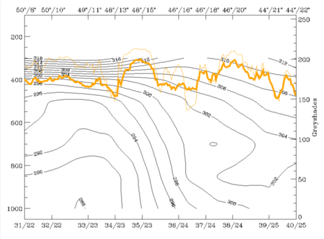
The cross section S crosses the Baroclinic Boundary, at about 41N/26W, consisting of low cloud top cells which show up in the sequence of small peaks in the IR pixel line. The unstable layer can also be identified in this area.
|
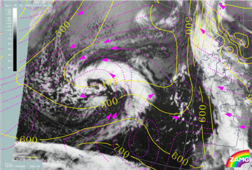
17 January 1997/00.00 UTC - Meteosat IR image; magenta: relative streams 294K - system velocity: 230° 11 m/s, yellow: isobars 294K
|
17 January 1997/00.00 UTC - Meteosat IR image; magenta: relative streams 300K - system velocity: 230° 11 m/s, yellow: isobars 300K
|
|
|
The 300K isentropic surface is more relevant for the Baroclinic Boundary. The biggest part of the Comma vortex is now higher than 400 hPa, but relative streams in the south of the spiral cross the Baroclinic Boundary mostly in a sinking manner. This is the area with low cloud tops which is accompanied by an unstable layer within the low troposphere, but in contrast to the Comma cloudiness the relative streams have descending components.
|
17 January 1997/06.00 UTC - Meteosat IR image; position of vertical cross sections indicated
|
17 January 1997/06.00 UTC - Vertical cross section R; black: isentropes (ThetaE), orange thin: IR pixel values, orange thick: WV pixel values
|
|
|
|
|
|
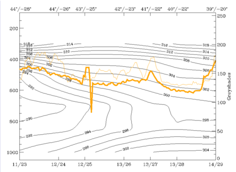
17 January 1997/06.00 UTC - Vertical cross section S; black: isentropes (ThetaE), orange thin: IR pixel values, orange thick: WV pixel values
|
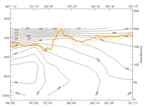
The cross section S crosses the Baroclinic Boundary between approximately 42N/24W and 41N/22W. Both cross sections contain an unstable layer up to about 650 hPa. The isentropic surfaces of 298K and 306K represent both cloud configurations.
|
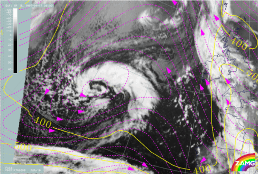
17 January 1997/06.00 UTC - Meteosat IR image; magenta: relative streams 298K - system velocity: 255° 18 m/s, yellow: isobars
298K
|
17 January 1997/06.00 UTC - Meteosat IR image; magenta: relative streams 306K - system velocity: 255° 18 m/s, yellow: isobars
306K
|
|
|
On the isentropic surface of 298K a warm conveyor belt-like relative stream can be seen in the Baroclinic Boundary rising from 700 hPa up to 400 hPa, a limiting stream line to a relative stream with northern directions accompanies the rearward edge of the Baroclinic Boundary.
On the isentropic surface of 306K a relative stream from behind crosses the Baroclinic Boundary area without any important vertical motion. In this area air masses with different origins and qualities are on top of each other, which leads to convective activity and higher cloud tops there.
The case of 13 February 1997 shows similarities but also differences from the above described case.
|
13 February 1997/06.00 UTC - Vertical cross section; black: isentropes (ThetaE), orange thin: IR pixel values, orange thick: WV
pixel values
|
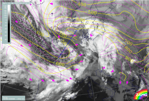
13 February 1997/06.00 UTC - Meteosat IR image; magenta: relative streams 298K - system velocity: 244° 8 m/s, yellow: isobars
298K, position of vertical cross secton indicated
|
|
|
The Comma stage at 06.00 UTC does not contain a closed cyclonic vortex within the relative streams, but only a trough. At this point of time the Baroclinic Boundary area over France is accompanied by sinking relative streams.
|
13 February 1997/18.00 UTC - Vertical cross section; black: isentropes (ThetaE), orange thin: IR pixel values, orange thick: WV
pixel values
|
13 February 1997/18.00 UTC - Meteosat IR image; magenta: relative streams 300K - system velocity: 273° 12 m/s, yellow: isobars
300K, position of vertical cross secton indicated
|
|
|
|
|
|
13 February 1997/18.00 UTC - Meteosat IR image; magenta: relative streams 300K - system velocity: 273° 12 m/s, yellow: isobars
300K
|
The isentropic surfaces which are used for the relative streams are 300K, which represents the lower levels of the troposphere, and 302K which is characteristic for the upper levels.
On the 300K surface the typical situation of relative streams accompanying fronts has developed. The limiting stream line is in the centre of the cloud band.
On the higher, 302K, layer the whole cloud band is within a relative stream from behind, which again represents a conditional unstable situation. The result of this situation was the development of numerous thunderstorms, which is represented in the chapter of weather events.


