BACK-BENT OCCLUSION - METEOROLOGICAL PHYSICAL BACKGROUND
by FMI
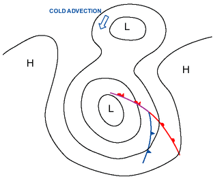
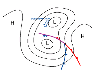
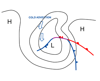
The bending back of an Occlusion due to cold advection
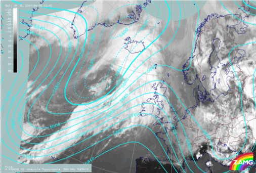
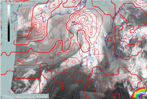
In this case there is a stationary or slowly moving low, towards which an occluded cyclone moves. They merge into each other to some extent and the cold advection from the cold side of the stationary low forces the occluded front of the cyclone to bend back.On 18 June 2001 at 00.00 UTC there is a Warm Occlusion moving eastwards over the Atlantic. An upper low, that appears just a weak trough on the lower levels, is located west of Iceland:
|
|
|
|
|
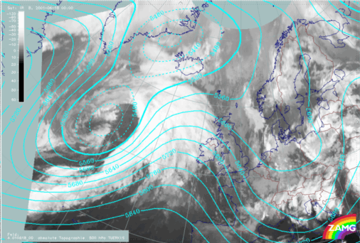
18 June 2001/00.00 UTC - Meteosat IR image; cyan: height contours 500 hPa
|
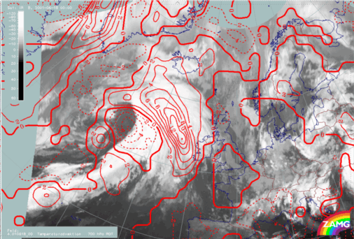
18 June 2001/00.00 UTC - Meteosat IR image; red: temperature advection 700 hPa
|
|
|
|
|
|
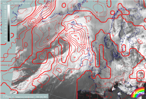
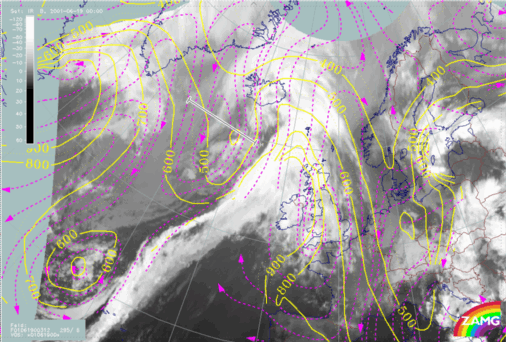
18 June 2001/12.00 UTC - Meteosat IR image; cyan: height contours 500 hPa
|
18 June 2001/12.00 UTC - Meteosat IR image; red: temperature advection 700 hPa
|
|
|
|
|
|
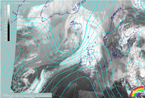
19 June 2001/06.00 UTC - Meteosat IR image; cyan: height contours 500 hPa
|
19 June 2001/06.00 UTC - Meteosat IR image; red: temperature advection 700 hPa
|
The bending back of an occlusion due to a stationary high pressure area
Sometimes Back Bent Occlusions form when they approach a stationary high pressure area. A moving cyclone slows down in front of a high. The occluded front stops and bends back due to the strengthening of the high pressure centre, while the Warm and the Cold Front continue slowly within a weaker high ridge area. In this case the Occlusion can be neutral, but usually these kind of Back Bent Occlusions occur in connection with cold continental highs during the winter. There is cold advection towards the occluded front from the edge of the high pressure, and the back bent front becomes a Cold Front.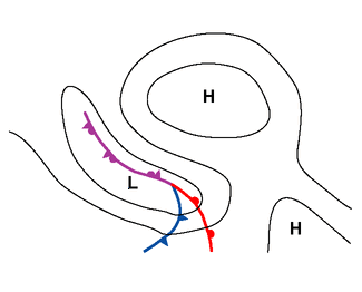
Relative streams
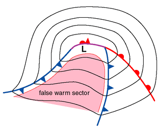
From the relative streams it can be seen that the cold air affecting the Occlusion originates from behind a low pressure in the cold airmass.The development of the Back Bent Occlusion:
- In the first stage there is a Warm Occlusion; the air within the occluded front is rising near the Occlusion point, and remains on a constant level in area of the tail.
- The Occlusion turns into a cold one, and finally it becomes a Cold Front. Behind the Cold Occlusion and the Cold Front the air is sinking.
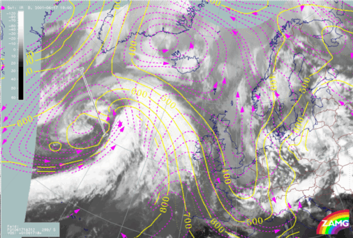
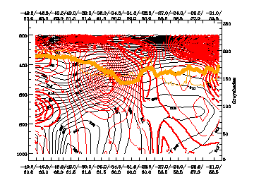
17 June 2001/18.00 UTC there is a Warm Occlusion southwest of Iceland:
|
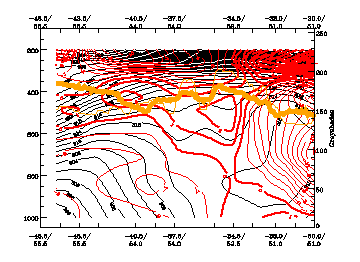
17 June 2001/18.00 UTC - Vertical cross section; black: isentropes (ThetaE), red thick: temperature advection - WA, red thin: temperature
advection - CA, orange thin: IR pixel values, orange thick: WV pixel values
|
17 June 2001/18.00 UTC - Meteosat IR image; magenta: relative streams 312K
|
|
|
|
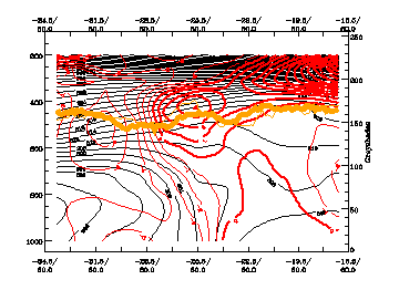
18 June 2001/12.00 UTC - Vertical cross section; black: isentropes (ThetaE), red thick: temperature advection - WA, red thin: temperature
advection - CA, orange thin: IR pixel values, orange thick: WV pixel values
|
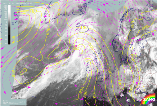
18 June 2001/12.00 UTC - Meteosat IR image; magenta: relative streams 312K
|
|
|
|
19 June 2001/00.00 UTC - Vertical cross section; black: isentropes (ThetaE), red thick: temperature advection - WA, red thin: temperature
advection - CA, orange thin: IR pixel values, orange thick: WV pixel values
|
19 June 2001/00.00 UTC - Meteosat IR image; magenta: relative streams 312K
|
|
|


