VORTICITY
by ZAMG
Development of spiral structures and the interaction of vorticity and vorticity advection
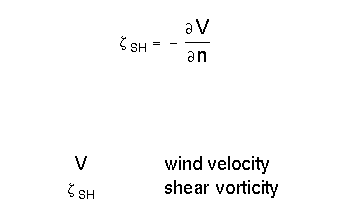
As already described in the chapter Vertical Motion - Omega Equation vorticity describes the rotation of a flow field, and is, therefore, a divergence property of the flow.
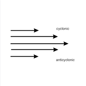
| > 0 | Cyclonic rotation |
| < 0 | Anticyclonic rotation |
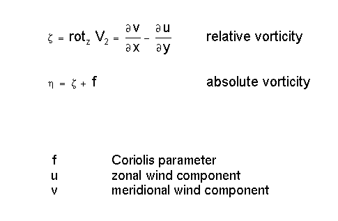
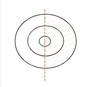
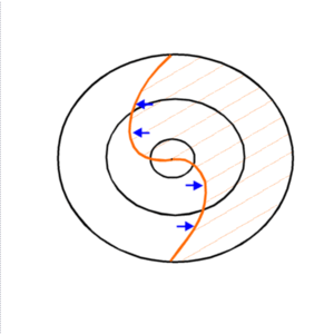
The influence of cyclonic vorticity on an originally unformed cloud field can be shown easily:
|
|
|
Consequently a clear interaction between the cloud-forming parameters of vorticity and vorticity advection can be observed:
|
|
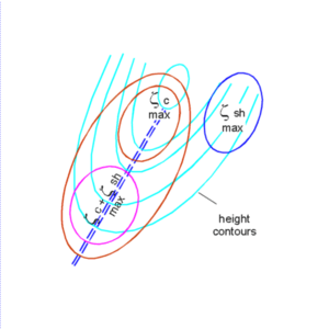
Vorticity consists of two contributing parts which allow an even deeper interpretation of typical cloud systems. These two parts can be distinguished easily if vorticiy is written in a natural coordinate system:
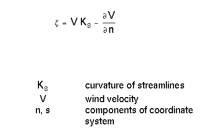
Therefore one part of vorticity originates from the curvature and the other one from the shear of the air flow.
Curvature vorticity
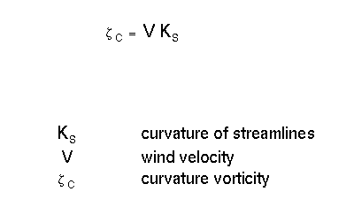
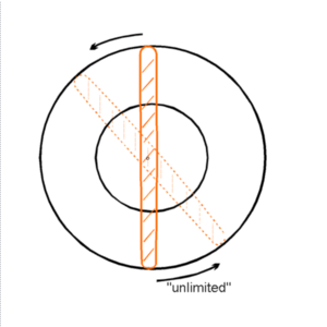
- Extra tropical low centres
- Commas
- Developing Waves
Shear vorticity
|
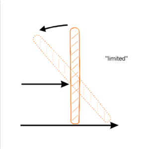
|
- Enhanced Cumuli (EC)
Typical locations for shear and curvature vorticity
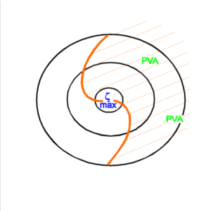
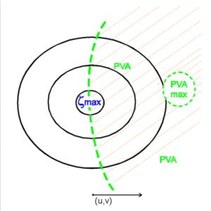
Looking at the most common streamline configuration of an upper level trough the following facts can be summarized:
|
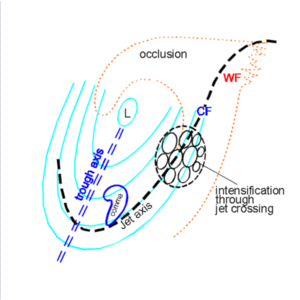
|
Typical cloud configurations associated with such a distribution of streamlines are:
- The main cloud spiral twisting around the low centre
- A Comma configuration immediately in front of the trough line
- Either an EC cloud configuration in the left exit region of a jet streak or the intensification of cloudiness within the front caused by the crossing of the jet streak
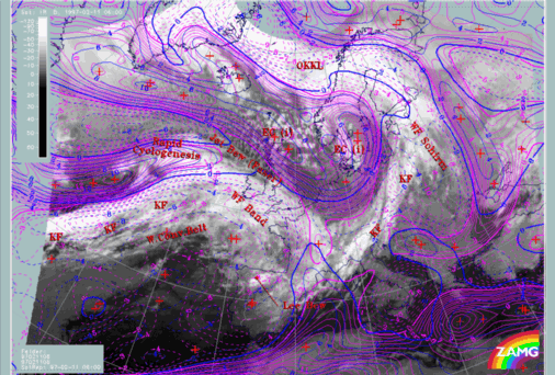
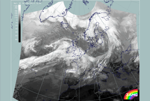
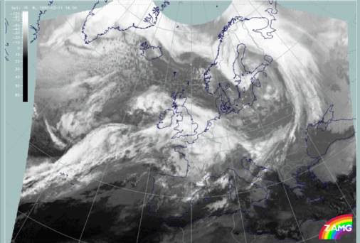
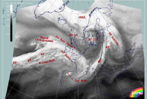
The case study of 11 February 1997/06 UTC shows some of the features discussed.
|
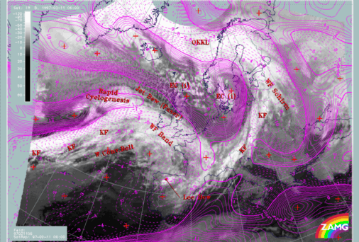
11 February 1997/06.00 UTC - Meteosat IR image; magenta: relative vorticity 300 hPa, SatRep overlay: names of conceptual models
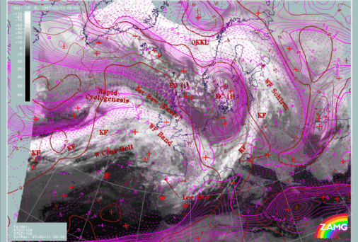
|
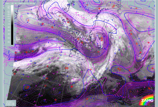
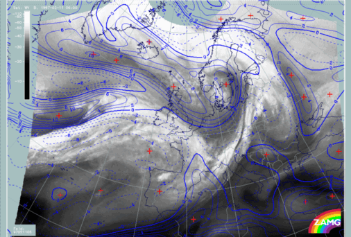
11 February 1997/06.00 UTC - Meteosat IR image; magenta: relative vorticity 300 hPa, blue: shear vorticity 300 hPa
|
|
|
The right image shows shear vorticity to total vorticity.
There are areas where both fields look very similar and which can be interpreted as situations where shear vorticity provides a large contribution. The following areas should be noted:
- The maximum over Sweden which is to the rear of the Cold Front (over Central Europe)
- The maximum north-east of Scotland
- The maximum behind the Atlantic Cold Front and west of the Rapid Cyclogenesis
- The maximum south-east of Greenland
There are areas where the total and shear vorticity deviate from each other and which can be interpreted as situations where shear vorticity has no big influence on the total vorticity. This means that curvature vorticity must play the more important role. The following areas should be noted:
- The vorticity maximum over Poland and Germany behind the Cold Front where shear vorticity does not have the shape of a maximum but, on the other hand, a big part of the cyclonic vorticity is accompanied by anticyclonic shear vorticity;
- A similar situation, but less distinct, can be seen on the westernmost boundary of the image panel to the rear of the Atlantic Cold Front;
- The area near Iceland, where the maxima in the two vorticity fields are shifted relative to each other.
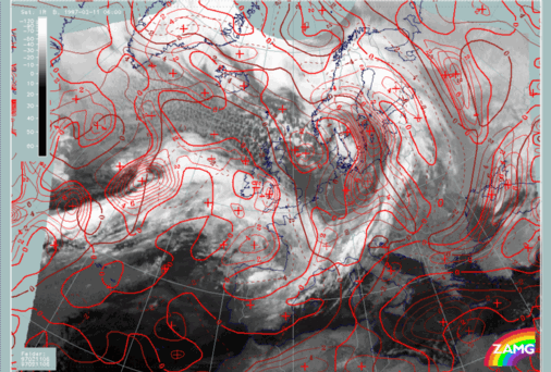
The following image has a third parameter, curvature vorticity, added.
|
11 February 1997/06.00 UTC - Meteosat IR image; magenta: relative vorticity 300 hPa, blue: shear vorticity 300 hPa, SatRep overlay:
names of conceptual models
|
11 February 1997/06.00 UTC - Meteosat IR image; magenta: relative vorticity 300 hPa, brown: curvature vorticity 300 hPa, SatRep overlay:
names of conceptual models
|
|
|
- The maximum over south Sweden behind the Cold Front over Central Europe
- The maximum over the Atlantic west of the Rapid Cyclogenesis (approximately 48N/33W) although in this case curvature is much weaker than shear
Areas where curvature vorticity deviates from shear vorticity but is very similar to the total vorticity field can be interpreted as areas where curvature is the dominant feature:
- The maximum over Poland and Germany behind the Cold Front over Central Europe
- The area close to the westernmost image panel boundary on the rear side of the Atlantic front
Areas where curvature vorticity deviates from the shape of shear and total vorticity can be interpreted as areas where shear plays the dominant role:
- The maximum north-east of Scotland which is rather weak in the curvature part
|
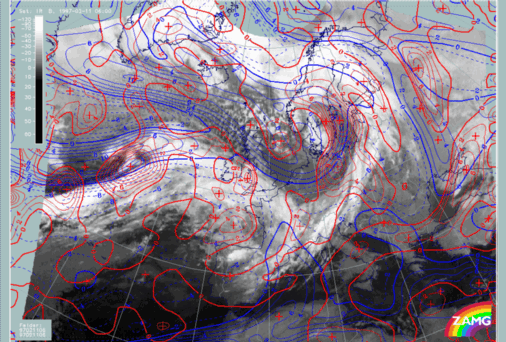
11 February 1997/06.00 UTC - Meteosat IR image; brown: curvature vorticity 300 hPa, red: positive vorticity advection (PVA) 300 hPa
|
11 February 1997/06.00 UTC - Meteosat IR image; blue: shear vorticity 300 hPa, red: positive vorticity advection (PVA) 300 hPa
|
|
|
- There are two PVA at the rear of the Cold Front over Central Europe; while the northern one over the Baltic Sea originates from a vorticity maximum consisting of both shear and curvature, the southern one over Poland is the result of a moving trough; shear is even anticyclonic there
- The PVA maximum over the North Sea indicates a moving shear vorticity maximum; the associated increased cellular cloudiness is typical for the left exit region of a jet stream
- The strong PVA maximum in the region behind the Rapid Cyclogenesis is again related to a PVA maximum which consists of both shear and curvature, however, but shear is still dominant; this is a typical conceptual model of Rapid Cyclogenesis which develops in the left exit region of a jet stream where frontogenetic conditions exist whilst in classical Wave development increasing curvature is the parameter
- The PVA maximum to the rear of the Atlantic Cold Front, close to the western boundary of the image, is an example of such a Wave development. It indicates the propagation of a curvature vorticity maximum (shear is very weak there); the following images for 12.00 and 18.00 UTC (see below) show that in this area increased cloudiness is indeed indicative of a wave development: at 12.00 UTC the cloud bulge can be seen at 44N/31W, at 18.00 UTC close to 49N/25W
|
11 February 1997/12.00 UTC - Meteosat IR image
|
11 February 1997/18.00 UTC - Meteosat IR image
|
|
|
|
11 February 1997/06.00 UTC - Meteosat WV image; SatRep overlay: names of conceptual models
|
11 February 1997/06.00 UTC - Meteosat WV image; blue: shear vorticity 300 hPa
|
|
|
- Over Poland and Germany behind the Cold Front; there is a distinct structure from about 51N/10E to 52N/15E and 55N/16E;
- Over the northern Atlantic from about 55N/40W to 61N/20W and further across Scotland to the Netherlands where it is connected with the structure mentioned above;
- Ahead of the Rapid Cyclogenesis from about 50N/37W to 56N/28W;
- To the rear of the Atlantic Cold Front from about 40N/40W to 48N/29W where it forms a very broad area.
Consequently, the combination of both sets of information, the Black Stripes in the WV image and the zeroline of shear vorticity in the numerical model field can give more complete information about the existence of the jet streams and the location of the jet axes. Such a combination is also a tool to detect model analysis errors.
In the demonstration case (right image) the following can be observed:
- There is a jet branch on the north-western Atlantic (compare the second point above) with the zeroline of shear vorticity close to the WV boundary and cyclonic shear on the left and anticyclonic shear on the right side; but the model zeroline deviates east of 20W southward from the WV structure; this may have its cause in the second main jet stream with the axis close to the back side of the Atlantic front;
- Also for this case the zeroline of shear vorticity with cyclonic values on the left and anticyclonic values on the right side fits relatively well to the black area in the WV image with two smaller exceptions: a deviation of the zeroline to the north close to the western boundary of the image and a deviation to the south at about 55N/15W. Both deviations cannot clearly be decided as a model error because such a far developed situation causes also some difficulties in an exact location from the WV image alone, but it seems to be obvious that the model cannot discriminate between the two jet branches over the British Isles and does not indicate the northern one over Scotland;
- The zeroline of shear vorticity over Germany and Poland closely follows the structure mentioned under the first point above and can be regarded as correct;
- The Black Stripe north of the cloud head of Rapid Cyclogenesis (mentioned under the third point above) is not typical of a jet situation when one notices that in the western jet stream the signs of cyclonic and anticyclomic shear vorticity appeared to be reversed.


