VORTICITY ADVECTION
by ZAMG
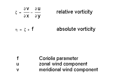
| > 0 | Cyclonic rotation |
|---|---|
| < 0 | Anticyclonic rotation |
| PVA | Positive Vorticity Advection |
|---|---|
| NVA | Negative Vorticity Advection |
There is a contribution to upward motion where term (1) of the omega equation is characterized by vertically increasing values of vorticity advection. (compare Vertical Motion - Omega Equation ).
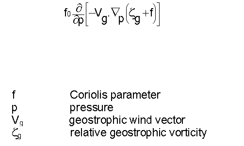
This is fulfilled where PVA increases with height or NVA decreases with height. From the synoptic point of view, the first condition is much more interesting than the second because the main cloud configurations are associated with PVA rather than NVA.
In satellite meteorology a simplification of this rule has to be used because, within an evaluation system based on single isobaric surfaces, a vertical variation of a parameter like PVA cannot be detected so obviously. Consequently the distinct PVA maxima at 500 and/or 300 hPa are used directly instead of their vertical variation. This is only possible under the assumption that wind increases with height. Although this is a reasonable assumption one has to bear in mind that it is not fulfilled everywhere and everytime. Nevertheless, satellite meteorology has proved that this is a valuable method and guides an evaluator to look into the main maxima in the numerical vorticity advection charts at higher levels.
Typical cloud configurations which are completely or partly associated with this parameter are:
- Wave developments
- Rapid Cyclogenesis
- Cold air features: Enhanced Cumuli (EC), Commas
- Jet streaks:
- EC, Comma
- Front Intensifications
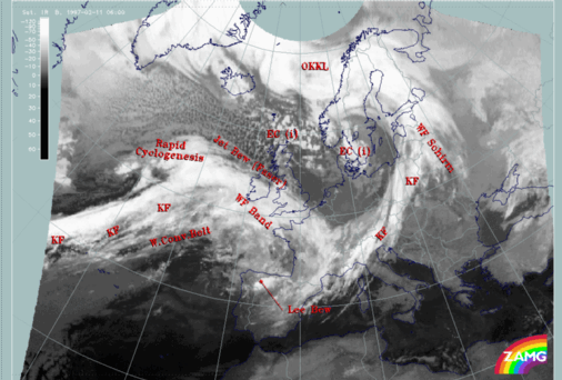
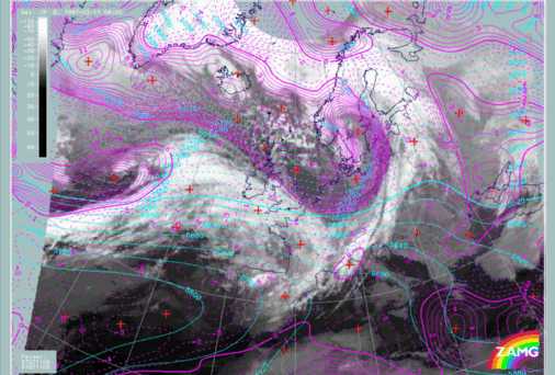
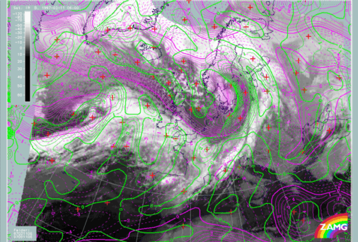
Some practical examples can be found in the case from 11 February 1997/06.00 UTC.
|
11 February 1997/06.00 UTC - Meteosat IR image; SatRep overlay: names of conceptual models
|
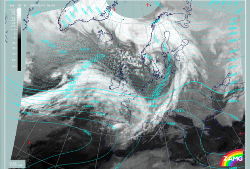
11 February 1997/06.00 UTC - Meteosat IR image; cyan: height contours 500 hPa
|
|
|
- In the middle of the image a pronounced, broad westerly stream prevails;
- Waves are superimposed on this stream leading to:
- Ridges over the Balkan states and west of Ireland
- Troughs over Germany and west of the area of the Rapid Cyclogenesis
- Low centres can be found over South Scandinavia, Iceland and south-west of Greenland
- A high centre exists over the Atlantic south of 40N
The following cyclonic vorticity maxima can be recognized:
- From the Ukraine (approximately around 49N/26E) to Finland and Sweden; it is closely connected to the upper level ridge there
- Over Portugal and the Atlantic west and south-west of the Iberian Peninsula; this area is associated with the high pressure area indicated in the upper level chart
Two relationships will be discussed:
- The relationship between vorticity and the vorticity advection field
- The relationship between the PVA maxima and typical cloud configurations
The following interesting situations can be extracted:
- An intensive PVA lobe from middle Scandinavia across the Baltic Sea and Poland to south Germany; it is in front of the relevant vorticity lobe, indicating the propagation of the upper level low and trough in this area; the PVA maximum is close to the rear edge of the frontal cloud band; in this case it is parallel to the cloud band and more to the rear of it. In other cases the PVA maxima may be superimposed on the frontal cloud band and consequently cause more intensified cloudiness there.
- Two PVA maxima at the rearward edge of the Atlantic Cold Front ("KF"); they are connected with two vorticity maxima there indicating the
eastward propagation of the rotation maxima;
- The eastern maximum (approximately 49N/29W) is accompanied by a slight cyclonic bulge at the rear edge of the frontal cloud band as well as with the cloud spiral emerging from below to the north;
- The western maximum (approximately 43N/36W) fits also to a slight cyclonic bulge at the rear edge of the frontal cloud band;
- A PVA maximum in the area of the Rapid Cyclogenesis which is connected to the propagation of the easternmost part of the south-west - north-east elongated vorticity lobe - it accompanies the area of Rapid Cyclogenesis;
- Two PVA maxima close to Scotland as well as north-west of it and above the North Sea; the western one (approximately 60N/10W) seems to indicate the propagation of an elongated vorticity maximum south of Iceland, the eastern one over the North Sea (approximately 56N/02E) cannot be associated with a special vorticity maximum; more detailed explanation follows in chapter Vorticity . The areas close to the two PVA maxima are associated with an increased cellular cloudiness; the cells are much bigger and brighter than those west of Scotland.
- There are several PVA maxima over the Atlantic south of the frontal cloud bands (approximately south of 50N); they appear in the anticyclonic part of vorticity and mark areas where vorticity becomes less anticyclonic. This can very clearly be seen near the PVA maximum close to Cornwall which is in front of a less anticyclonic area; although according to the mathematical relation these PVA maxima should also contribute to upward motion, to date no practical use could be derived from them.
In this chapter the maxima of vorticity have been studied and compared to the PVA maxima; in the following chapter a further separation of the vorticity maxima together with a deeper interpretation of PVA maxima will be shown.


