BASIC CHANNELS
by FMI, KNMI and ZAMG
METEOSAT (MOP, MTP)
| Name | Spectral Range in Micrometres | Primary Use |
|---|---|---|
| VIS | 0.5 - 0.9 | Daytime cloud-mapping and albedo determination |
| IR | 10.5 - 12.5 | Day and night cloud-mapping and determination of surface temperature |
| WV | 5.7 - 7.1 | WV features for synoptic purposes; WV content in upper troposphere UTH (Upper Tropospheric Humidity) |
VIS - VISible: 0.5 - 0.9 micrometre
The satellite receives that part of the sun radiation which is reflected by the earth surface or by cloudiness. It is a so-called window channel which means that radiation is not significantly absorbed by the gases in the troposphere; this means in other words that it is possible to look as though through a window downward to the radiating surface which can be earth surface or cloud tops.Different grey shades in this VIS channel represent different values of albedo:
| Bright values | High albedo |
Thick clouds
Land surfaces |
|---|---|---|
| Grey values | Low albedo | Thin translucent clouds |
| Dark values | Almost no reflection | Water and vegetation |
IR - InfraRed: 10.5 - 12.5 micrometre
The satellite receives radiation which is emitted by the earth and the clouds because of their temperature. IR is a window channel, as is VIS, and with the same consequences.Different grey shades in the IR channel represent different temperatures of the radiating surface which can be the earth surface or the cloud tops. The grey shades presented in the IR images are reversed (white becomes black) to get a similar appearance to the VIS image.
| Bright values | Low temperatures | Cold (high) cloud tops |
|---|---|---|
| Grey values | Middle temperatures | Middle cloud tops |
| Dark values | Warm temperatures | Hot land or sea surface |
WV - Water Vapour: centred at 6.3 micrometre
The satellite receives radiation which is emitted by the water vapour in the upper troposphere (approximately above 600 hPa up to 300 hPa). The WV channel represents an absorption measurement of the WV absorption band. This means that radiation from below 600 hPa is absorbed by the WV in the layer above which according to the radiation laws (Kirchhoff) becomes a radiating surface itself.Different grey shades in the WV channel represent different WV content above 600 hPa:
| Bright values | Liquid water | Clouds |
|---|---|---|
| Grey values | Water vapour | Water vapour with varying intensity |
| Dark values | Very low water vapour | Dry upper troposphere |
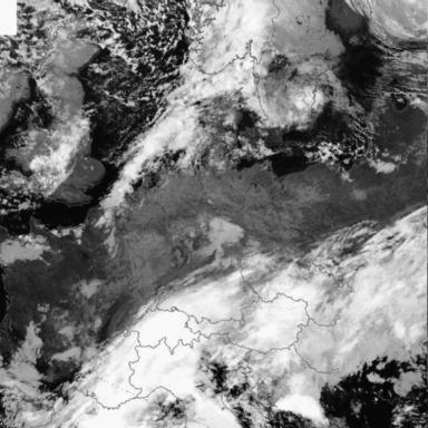
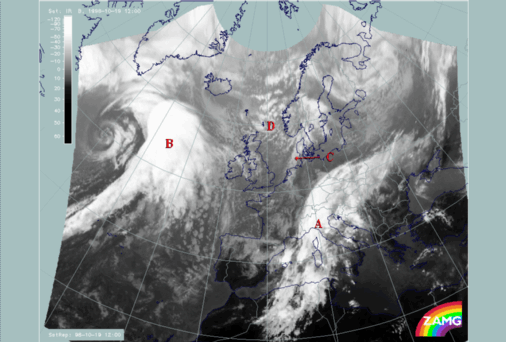
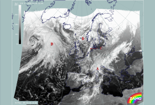
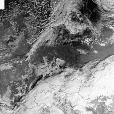
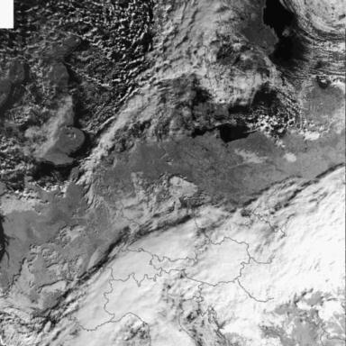
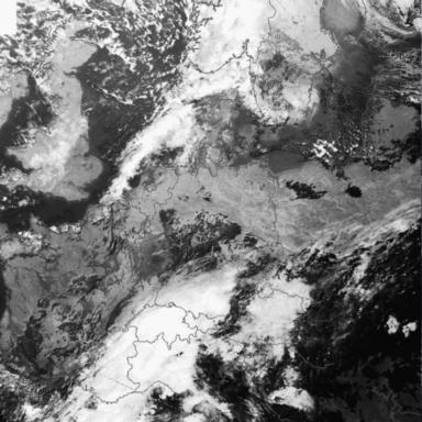
Comparison of the three channels IR, VIS and WV: 19 October 1998/12.00 UTC
|
19 October 1998/12.00 UTC - Meteosat IR image
|
19 October 1998/12.00 UTC - Meteosat VIS image
|
|
|
|
|
|
19 October 1998/12.00 UTC - Meteosat WV image
|
Looking at the IR image of 12.00 UTC (top left image) the following main synoptic to mesoscale cloud configurations can be discriminated:
| A | A cloud band of a Cold Front extending from north Africa across the Alpine region to the Ukraine representing a Cold Front with a Wave feature over the Alps |
|---|---|
| B | A cloud band, a huge cloud shield and a distinct cloud spiral over the Atlantic representing a frontal system consisting of Cold Front, Warm Front and Occlusion |
| C | A smaller scale cloud spiral extending from Sweden across Denmark to the Netherlands representing a well developed Comma system |
| D | Large areas of cellular cloudiness with different vertical extension representing cold air streaming over warmer ground |
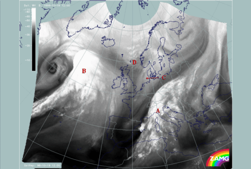
Some specific areas will be selected and compared in the three channels IR, VIS and WV (compare Artificial and Combination Channels - Meteosat combination VIS + IR )
| A1 |
The easternmost part of the frontal cloud band A located over the Ukraine
Frontal cloud band with lower cloudiness in general but some cells embedded; high fibres at the anticyclonic jet side superimposed casting a shadow on the lower cloud ceiling jet axis parallel to northern cloud boundary with very dry air on the cyclonic side |
|---|---|
| A2 |
The Wave area over north Italy - Switzerland - west Austria and south Germany
Wave or at least Wave - like bulge with a high smooth cloud shield superimposed; very dry air behind support Wave process |
| A3 |
Two mesoscale cells MCSs over the western Mediterranean (40.5N/03E and 41N/06E)
Thunderstom complexes and MCSs with the thick cloudiness in the upstream part and a cirrus shield downstream; different synpotic environment for the two cells |
| B1 |
Cloud shield over the Atlantic
Huge area of humid air in the upper layer; partly cloudiness in the Warm Front Shield but humidity extends far to the south with some cloud fibres embedded; very dry air to the north extending from south Iceland across Scotland into the North Sea |
| B2 |
Cloud band over the Atlantic (36N/35W - 50N/30W)
Cold Front cloud band with multilayered cloudiness and high humidity supply in the upper layer; rising of cloud tops from the leading to the rearward edge, similar to Ana front model |
| B3 |
Cloud spiral west of the cloud shield (around 57N/36W)
Typical Occlusion cloud band of the cold conveyor belt type; cloud spiral of low centre well developed; probably cut-off of separate Comma |
| D1 |
Cloud cells west of the comma feature and the Norwegian coast:
Thick cold air cells with large humidity supply in the higher layer; additional rising to merely convective effects |
| D2 |
Cloud cells west, north-west of Scotland and north Ireland
Typical cold air cloudiness of the open cell type; no humidity supply from above |
| - |
Additional WV features over north Spain - the Pyrenees - France:
Cold Air Cloudiness in lower layers but completely different process in upper layer: very early stage of Upper Level Low development possible |
The advantage of the geostationary satellite Meteosat is the high temporal frequency of a large part of the earth. NOAA images are available at different points of time.
NOAA AVHRR
| Channel Number | Spectral Range in Micrometres | Name | Present on NOAA | Primary use |
|---|---|---|---|---|
| 1 | 0.58 - 0.68 | VIS 1 | 12, 14, 15 | Daytime cloud-mapping and albedo determination |
| 2 | 0.725 - 1.1 | VIS 2 | 12, 14, 15 | Daytime land sea delineation and cloud-mapping and above sea |
| 3A | 1.158 - 1.164 | NIR 1.6 | 15 | Discrimination between snow, ice and cloud, aerosol determination |
| 3B | 3.55 - 3.93 | NIR 3.7 | 12, 14, 15 | Night time cloud detection |
| 4 | 10.3 - 11.3 | IR 4 | 12, 14, 15 | Day and night cloud-mapping and determination of surface temperature |
| 5 | 11.5 - 12.5 | IR 5 | 12, 14, 15 | Day and night cloud-mapping and determination of surface temperature |
VIS 1 - VISible 1: 0.58 - 0.68 micrometre
The satellite receives that part of the solar spectrum which is reflected by the underlying surface, which can be land, sea or cloud. It is a so-called window channel which means that radiation is not significantly absorbed by the gases in the troposphere; this means in other words that it is possible to look as though through a window downward to the radiating surface which can be earth surface or cloud tops.Different grey shades in this VIS 1 channel represent different values of albedo:
| Bright values | High albedo |
Thick clouds
Land surfaces |
|---|---|---|
| Grey values | Low albedo | Thin translucent clouds |
| Dark values | Almost no reflection | Water and vegetation |
VIS 2 - VISible 2: 0.725 - 1.1 micrometre
The satellite receives that part of the solar spectrum which is reflected by the underlying surface, which can be land, sea or cloud. It is a so-called window channel which means that radiation is not significantly absorbed by the gases in the troposphere; this means in other words that it is possible to look as though through a window downward to the radiating surface which can be earth surface or cloud tops.Different grey shades in this VIS 2 channel represent different values of the reflected radiation:
| Bright values | High reflectivity |
Thick clouds
Land surfaces |
|---|---|---|
| Grey values | Low reflectivity | Semi-transparent clouds |
| Dark values | Almost no reflection | Water and vegetation |
NIR 3 - Near InfraRed 3: 1.58 - 1.64 micrometre
This IR channel is located in that part of the spectrum where reflected sunlight still plays a role during daytime. On the other hand, hot surfaces, like forest fires, stubble burning after harvesting, volcanoes, etc, have their largest radiation contribution around this wavelength. Finally, water droplets of a size comparable to the wavelength can be abundant in the atmosphere, especially in fog layers, causing strong reflection of sunlight at this wavelength. In other words, the NIR 3.7 channel is partly a thermal emission channel and partly a reflectivity sensing channel. This implies that great care is needed with the interpretation of its measured values.Different grey shades in this NIR 3.7 channel represent different values of brightness temperature:
| Bright values | Low temperature | Cold cloud tops |
|---|---|---|
| Grey values | Intermediate temperature | Medium and low clouds |
| Dark values | High temperature, high reflectivity | Land and sea surface, top of fog layer |
IR 4 - InfraRed 4: 10.3 - 11.3 micrometre
Being located in one of the atmospheric window regions of the thermal part of the spectrum, this channel IR 4 measures the emitted radiation from the highest optically dense surface in the earth-atmosphere system. Since these surfaces (land, sea, clouds) are not perfect black body radiators, the brightness temperature observed can differ from the temperature of the emitting surface with the emissivity of that surface.Different grey shades in this IR 4 channel represent different values of brightness temperature:
| Bright values | Low temperature | Cold cloud tops |
|---|---|---|
| Grey values | Intermediate temperature | Medium and low clouds |
| Dark values | High temperature | Land and sea surface |
IR 5 - InfraRed: 11.5 - 12.5 micrometre
Being located in one of the atmospheric window regions of the thermal part of the spectrum, this channel IR 5 measures the emitted radiation from the highest optically dense surface in the earth-atmosphere system. Since these surfaces (land, sea, clouds) are not perfect black body radiators, the brightness temperature observed can differ from the temperature of the emitting surface with the emissivity of that surface.Different grey shades in this IR 5 channel represent different values of brightness temperature:
| Bright values | Low temperature | Cold cloud tops |
|---|---|---|
| Grey values | Intermediate temperature | Medium and low clouds |
| Dark values | High temperature | Land and sea surface |
Examples of the five AVHRR channels
Area to be examined:
| In western upper corner | Great Britain |
|---|---|
| In eastern upper corner | Baltic Sea |
| Below in western corner | north-eastern Spain |
| Below in eastern corner | Balkans |
AVHRR - VISible channel 1
| VIS 1 |
Perhaps Wave or at least Wave - like band in the lower part of the picture. Over North Sea typical Cold Air Cloudiness of the open cells. The south-north oriented cloud band has Cu form cloudiness. |
|---|
AVHRR - VISible channel 2
| VIS 2 |
Perhaps Wave or at least Wave - like band in the lower part of the picture. Over North Sea typical Cold Air Cloudiness of the open cells. The south-north oriented cloud band has Cu form cloudiness. |
|---|
AVHRR - Near InfraRed channel 3
Differences compared to VIS channels and combination 1,2,4 image (compare Artificial and Combination Channels - AVHRR combination channel 1 + 2 + 4 ):
| NIR 3 |
White cloud band or wave area is superimposed by Ci clouds. Downwind there are lower clouds. Highest Cu clouds in the upper part of the picture are seen white and lower clouds much darker as well as low clouds over land areas. |
|---|
AVHRR - InfraRed channel 4
AVHRR - InfraRed channel 4