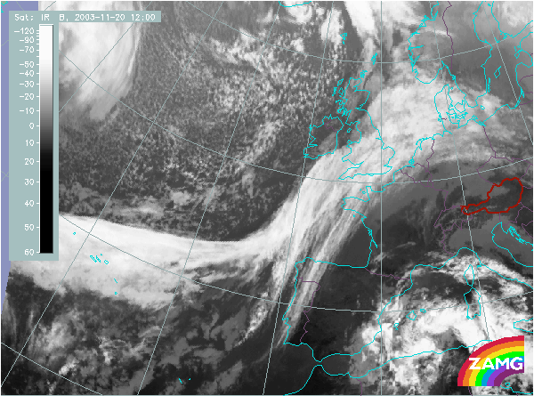
Does this actual case reflect the conceptual model well? Compare the ideal configuration!
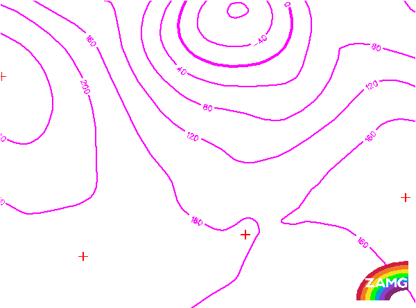

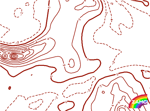
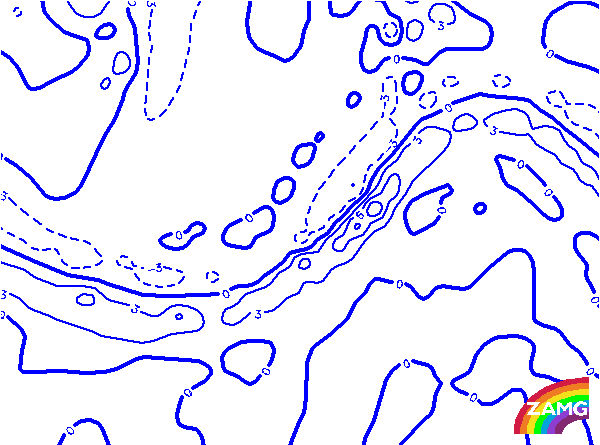
Height Contours 1000 hPa:
- Upper Wave S of Ireland:
There is a pronounced surface trough, typical for a Cold Front, but it is not to the rear of the cloud band in the area of the Wave bulge but closer to the leading edge of it. This is typical for an Upper Wave. - Upper Wave over the Atlantic (40N/30W):
There is no frontal trough configuration at this stage. Indeed, the isolines are part of a high pressure area.
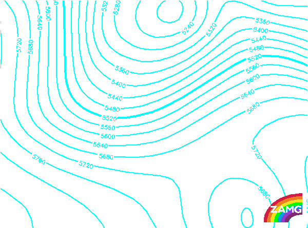
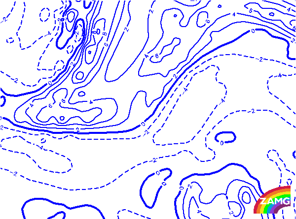
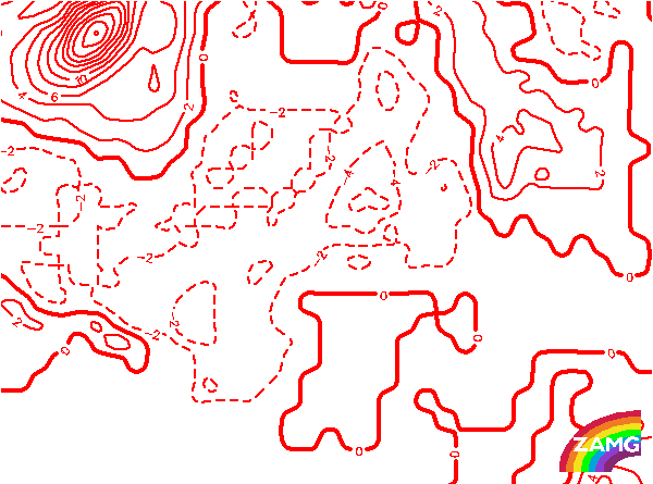
Height contours 500 hPa:
- Upper Wave S of Ireland:
There is a broad, pronounced upper level trough behind the cloud bulge of an Upper Wave. A narrowing and intensification of this trough, common for Upper Waves, cannot be seen yet. - Upper Wave over the Atlantic (40N/30W):
The broad trough behind both parts of the frontal system shows a sharpening of the trough immediately behind the small Wave bulge. This is a typical indicator of an Upper Wave.
Height Contours 300 hPa:
- Upper Wave S of Ireland:
There is a broad pronounced upper level trough behind the cloud bulge of an Upper Wave; a narrowing and sharpening of this trough , as it is very usual for Upper Waves cannot be seen yet. - Upper Wave over the Atlantic (40N/30W):
The broad trough behind both parts of the frontal system shows a sharpening of the trough immediately behind the small Wave bulge. This is a typical sign for an Upper Wave.
Isotachs 300 hPa:
- Upper Wave S of Ireland:
There is a distinct jet streak, and the bulge in the Upper Wave cloud is in the right entrance region. This is very typical for the initial stages of an Upper Wave. - Upper Wave over the Atlantic (40N/30W):
There is also a pronounced jet streak and the slight Wave bulge is in the jet streak entrance region. However, the jet streak and jet axis is shifted to the south in relation to the cloud edge
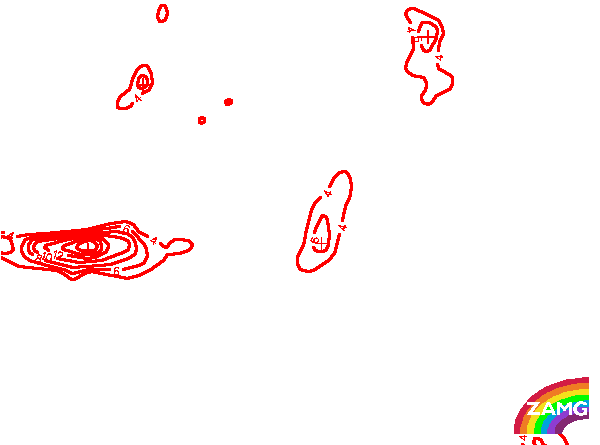
Curvature Vorticity 300 hPa:
- Upper Wave S of Ireland:
There is a distinct maximum in curvature at high levels indicating a sharp upper level trough. This is a typical sign for an Upper Wave. - Upper Wave over the Atlantic (40N/30W):
The same is true for the second Upper Wave, but the curvature maximum is even stronger.
Shear Vorticity 300 hPa:
The zeroline of shear vorticity at 300 hPa which is a good measure for the jet axis is along the rearward boundary of the cloud band. This is very typical for the conceptual model of a Cold Front and an Upper Wave within this Cold Front. Especially at the cyclonic side of the W-E oriented part of the cloud band a distinct maximum of shear vorticity indicates a pronounced jet streak there.
The zeroline of shear vorticity at 300 hPa which is a good measure for the jet axis is along the rearward boundary of the cloud band. This is very typical for the conceptual model of a Cold Front and an Upper Wave within this Cold Front. Especially at the cyclonic side of the W-E oriented part of the cloud band a distinct maximum of shear vorticity indicates a pronounced jet streak there.
PVA 300 hPa:
- Upper Wave S of Ireland:
There is a distinct PVA maximum at 300 hPa within, but a bit downstream from the cloud bulge of the Upper Wave. If this parameter is compared to that showing curvature vorticity, the connection of both fields is clearly seen. This is very typical for an Upper Wave. - Upper Wave over the Atlantic (40N/30W):
There is a distinct PVA maximum at 300 hPa within, but a bit downstream from the cloud bulge of the Upper Wave. If this parameter is compared to that showing curvature vorticity, the connection of both fields is clearly seen. This is very typical for an Upper Wave. This western Upper Wave has stronger values of curvature and PVA than the Upper Wave to the east.
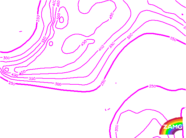
Height of PV=2 units:
- Upper Wave S of Ireland:
On the rear side of this Upper Wave the gradients show that dry stratospheric air is not directly behind the Upper Wave but further to the NW. This is also connected to the fact that the upper level trough has not yet sharpened. - Upper Wave over the Atlantic (40N/30W):
In this case there is already a PV anomaly with dry stratospheric air reaching down to 450 hPa. This is in accordance with the already very sharp upper level trough behind the Wave bulge. And this is also typical for a well developed Upper Wave.
TFP:
The TFP accompanies the whole frontal cloud band. While it is close to the leading edge of the Cold Front band in the W-E oriented part, indicating an Ana Cold Front, it is more to the rear of the N-S oriented cloud band. Both configurations are in agreement with the conceptual model of an Upper Wave.
The TFP accompanies the whole frontal cloud band. While it is close to the leading edge of the Cold Front band in the W-E oriented part, indicating an Ana Cold Front, it is more to the rear of the N-S oriented cloud band. Both configurations are in agreement with the conceptual model of an Upper Wave.
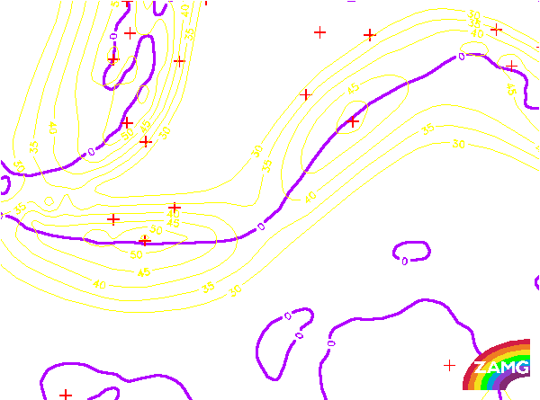
Temperature Advection 700 hPa:
- Upper Wave S of Ireland:
There is CA in the whole area of the Upper Wave cloud bulge, as well as in the surrounding area of the Cold Front cloud band. This is the most important parameter to determine whether a cloud bulge is a classical Wave or an Upper Wave. In this example there is a very typical distribution of temperature advection. - Upper Wave over the Atlantic (40N/30W):
In this more western Upper Wave there is also an extended area of CA which provides a hint for identifying this Wave bulge as an Upper Wave. But WA can be seen in the leading edge of the Cold Front. Whilst this contradicts somewhat the classical situation, this Wave bulge does appear as a very distinct Upper Wave, so this small deviation in TA from normal is not so important.