STORM CATASTROPHE 25 - 28 DECEMBER 1999 - NUMERICAL MODEL FORECAST PROBLEMS
by KNMI
Behaviour of the ECMWF model
The storm of the 26th (Lothar) only appeared in the 18 hour forecast from 12.00 UTC on the 25th and not at all in preceding forecasts (except D 71/2). Analysis of the storm was also difficult; the 9 and 6-hour forecasts were better for intensity rather than analysis. For the 27th (Martin) there was really nothing in the short range forecasts, even though it had been present in the D+6, 7 and 8 forecasts. The large-scale development was well predicted, associated with a strengthening of the sub-tropical high and the establishment of a straight and very strong jet. The track of the second cyclone could be followed in data assimilation over the Atlantic, but was lost during the 26th. There were data, particularly one SHIP, which were not used correctly and flagged. The main point is that these developments were, in principle, predictable since medium range forecasts showed correct developments. It was more a problem of data assimilation and the mis-use of data by the models somehow caused the cyclones to be lost.
Behaviour of the HIRLAM model
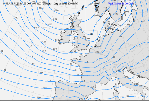
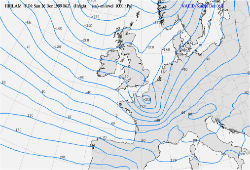
The KNMI Hirlam model performed badly in both cases. Although, for the forecast period less than 18 hours ahead, Hirlam did forecast the position of Lothar reasonably well, its development was greatly underestimated even in the nowcast period of less than 6 hours ahead. The analyses were not correct and resulted in an underestimation of central surface pressure.The +24 hours forecast from the Hirlam model run from Christmas day 25 December 1999/06.00 UTC showed only a weak trough in the 1000 hPa height field at the position of Lothar (see left chart below). A deeper trough is calculated over the Netherlands. By 26 December at 06.00 UTC, a deep low with its centre SW of Paris was a dominant feature, but there was no trough over the Low Countries (see right chart below) This was a result of severely underestimated development of Lothar (in terms of warm advection in front of the low).
|
25 December 1999/06.00 UTC - HIRLAM/KNMI +24 hours forecast height 1000 hPa
|
26 December 1999/06.00 UTC - HIRLAM/KNMI Analysis height 1000 hPa
|
|
|
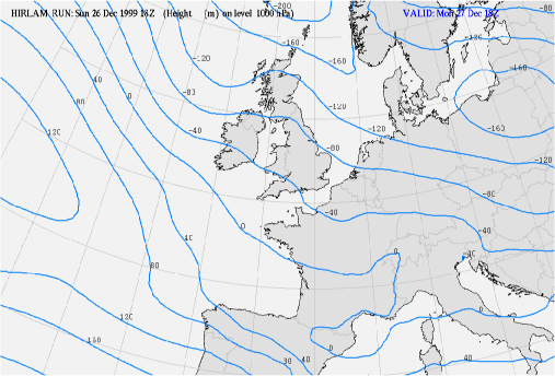
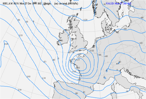
The +24 forecast of the 1000 hPa height field from the run of 26 December 1999 18.00 UTC only shows a very weak and flat trough near the mouth of the river Loire, the position of Martin at that time (see left chart below). In reality Martin was a very deep and extensive low with a much larger radius than Lothar. (see right chart below).
|
26 December 1999/18.00 UTC - HIRLAM/KNMI +24 hours forecast height 1000 hPa
|
27 December 1999/18.00 UTC - HIRLAM/KNMI Analysis height 1000 hPa
|
|
|
Other models
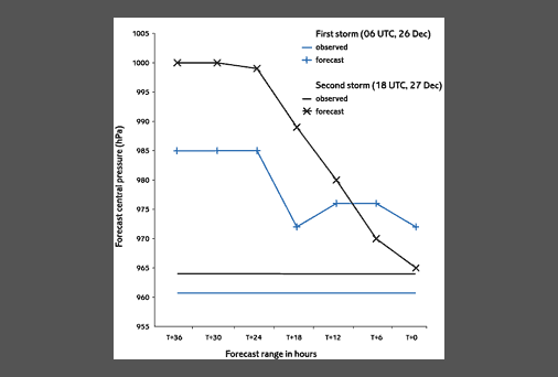
Other NWP models across Europe also failed to predict the severity of the storms, although the French ARPEGE model and its high resolution sub-model ALADIN provided reasonable guidance for Lothar.Most models were generally very poor in the forecast a day before the storms but improved with shorter lead times (see the illustration below from the behaviour of the UK model).
Even scattero-meter wind data and data from ATOVS (Advanced Tiros Operational Vertical Sounder) used in reruns of some models resulted in little improvement in forecasts.
Satellite Reports (SatRep) were not produced during the two Christmas holidays but on the 27/06.00 UTC the SatRep (made by ZAMG) indentified Martin as the Conceptual Model: Rapid Cyclogenesis (RaCy) with the following text:
"16. Rapid Cyclogenesis: Atlantic 4918W analysis from the satellite loop cloud head in weak CA !! (-2K/12 hours)." This indicates that this rapid development was detected using satellite data only and that the models did not support this diagnosis. In the 27/12.00 UTC SatRep, produced by KNMI, the text was similar for this RaCy.
The obvious discrepancy between model forecast and SatRep analysis certainly increased the attentiveness of the forecaster to this problem and made her/him aware that he has to question the model forecasts (in this case both ECMWF and HIRLAM).


