FLOOD CATASTROPHE 04 - 08 JULY 1997 - OVERVIEW
by ZAMG
General remarks concerning the flood catastrophe
ZAMG thanks Mr. Struzik from the Institute of Meteorology and Water Management in Krakow for the following information as well as his fruitful participation in discussions.Experience from Poland, one of the countries which was affected most, can be used to characterise the overall situation. The following topics can be summarised:
- The most critical area was the mountainous area in the south of Poland along the border to the Czech Republic as well as to Slovakia.
- As will be seen in the chapters below, the reason was a prolonged northerly flow; thus, orographic influence in form of Stau cloud and Stau precipitation was important.
- Precipitation amounts in Poland around 450 mm are typical in this situation but amounts of up to 600 mm were actually observed. In the Czech Republic, precipitation amounts reached 500 mm.
- Most of these values are close to the annual mean of precipitation.
- As it can be observed very often with catastrophic weather situations, the catastrophic situation was not the result of one extraordinary synoptic
event, but the result of a typical synoptic situation which was very long-lasting. Also in this case, the time factor was the main reason. For
Poland the following periods of heavy rain can be summarised:
- 04 - 05 July: intensive convective situation
- 05 - 08 July: Upper Level Low; Baroclinic Boundary
- 09 July: New development of very intensive convective cells resulting in 200 mm additional precipitation
- 18 - 21 July: Upper Level Low; repetition of previous situation
- Consequently, and similar to other catastrophic situations, wrong forecasts or mis-interpretations of the synoptic situation are not the main problem; to overcome such situations is not so much a meteorological forecast problem but a technical and social organisational one.
This case study concentrates on the situation between 04 and 08 July 1997.
In this chapter a very rough overview of the different stages of the synoptic situation is given.
1. Trough Stage
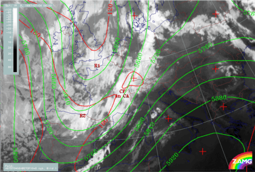
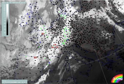
A frontal cloud band (Cold Front in Cold Advection) extends from the western Mediterranean across France and Switzerland to Germany. It is embedded in an upper level SW stream. To its rear, two rather extended cloud areas (R1 and R2) are situated in the upper level trough.
04 July 1997/06.00 UTC - Meteosat IR image; red: height contours 1000 hPa, green: height contours 500 hPa
04 July 1997/06.00 UTC - Meteosat IR image; weather events (green: rain and showers, blue: drizzle, cyan: snow, red: thunderstorm with precipitation,
purple: freezing rain, orange: hail, black: no actual precipitation or thunderstorm with precipitation)
04 July 1997/18.00 UTC - Meteosat IR image; red: height contours 1000 hPa, green: height contours 500 hPa
04 July 1997/18.00 UTC - Meteosat IR image; weather events (green: rain and showers, blue: drizzle, cyan: snow, red: thunderstorm with precipitation,
purple: freezing rain, orange: hail, black: no actual precipitation or thunderstorm with precipitation)
- Frontal cloud band
- Front Intensification by Jet Crossing: FI by Jet
- Cold air features
2. Tie-off Stage
During the tie-off stage an Occlusion - like cloud configuration develops from the frontal cloud band and the cold air features. But although the appearance of an Occlusion cloud spiral develops, the genesis is completely different from a classical Occlusion process.
05 July 1997/06.00 UTC - Meteosat IR image; red: height contours 1000 hPa, green: height contours 500 hPa
05 July 1997/06.00 UTC - Meteosat IR image; weather events (green: rain and showers, blue: drizzle, cyan: snow, red: thunderstorm with precipitation,
purple: freezing rain, orange: hail, black: no actual precipitation or thunderstorm with precipitation)
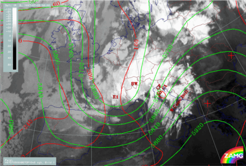
05 July 1997/12.00 UTC - Meteosat IR image; red: height contours 1000 hPa, green: height contours 500 hPa
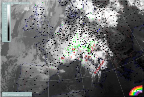
05 July 1997/12.00 UTC - Meteosat IR image; weather events (green: rain and showers, blue: drizzle, cyan: snow, red: thunderstorm with precipitation,
purple: freezing rain, orange: hail, black: no actual precipitation or thunderstorm with precipitation)
- Development of Occlusion - like cloud features
3. Cut-off Stage
1st cut-off phase: Extended low with several centres
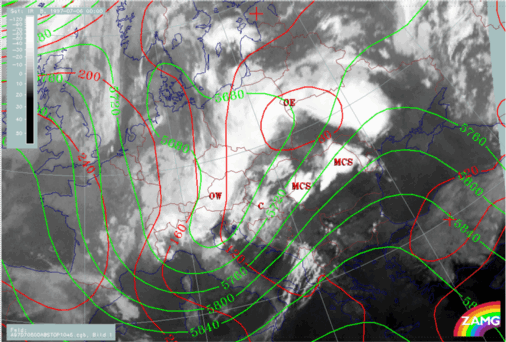
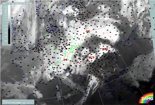
During this phase, an extended Upper Level Low with several centres has developed. An Occlusion - like cloud band (OE - OW) still exists. The most interesting developments occur over Austria - Hungary - Slovakia - Croatia where a new cut-off process seems to be under way (C). In the eastern parts over Romania and Ukraine intensive convective developments take place (MCSs).
06 July 1997/00.00 UTC - Meteosat IR image; red: height contours 1000 hPa, green: height contours 500 hPa
06 July 1997/00.00 UTC - Meteosat IR image; weather events (green: rain and showers, blue: drizzle, cyan: snow, red: thunderstorm with precipitation,
purple: freezing rain, orange: hail, black: no actual precipitation or thunderstorm with precipitation)
- Development of Occlusion - like cloud features
- ULL cut-off
2nd cut-off phase: Separate main ULL centre
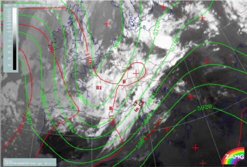
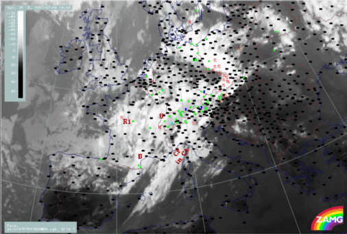
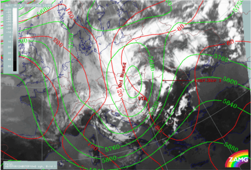
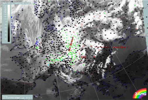
This phase is characterised by the cut-off stage of an intensive, huge ULL area over Central Europe (Austria - Hungary - Czech Republic - Slovakia - Slovenia - Croatia - Bosnia). It is a very stationary phenomenon. The first example (06/12.00 UTC) describes the beginning of a cut-off low, the second example (07/12.00 UTC) the fully developed stage.At 06 July/12.00 UTC, two cloud bands, cyclonically curved towards each other, indicate the completion of the cut-off process. The convective developments along the eastern boundary are very intensive.
06 July 1997/12.00 UTC - Meteosat IR image; red: height contours 1000 hPa, green: height contours 500 hPa
06 July 1997/12.00 UTC - Meteosat IR image; weather events (green: rain and showers, blue: drizzle, cyan: snow, red: thunderstorm with precipitation,
purple: freezing rain, orange: hail, black: no actual precipitation or thunderstorm with precipitation)
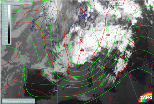
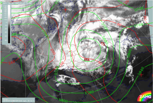
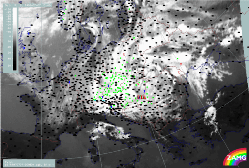
07 July 1997/12.00 UTC - Meteosat IR image; red: height contours 1000 hPa, green: height contours 500 hPa
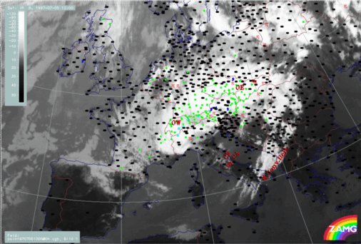
07 July 1997/12.00 UTC - Meteosat IR image; weather events (green: rain and showers, blue: drizzle, cyan: snow, red: thunderstorm with precipitation,
purple: freezing rain, orange: hail, black: no actual precipitation or thunderstorm with precipitation)
- Baroclinic boundary and rotation of convective lines
Contents of phases described in separate chapters
- Frontal cloud band
- Front intensification by Jet Crossing: FI by Jet
- Cold air features
- Development of Occlusion - like cloud features
- Main ULL cut-off
- Baroclinic Boundary and rotation of convective lines

