Hail Catastrophe 13 May 2003 - Nowcasting
by ZAMG
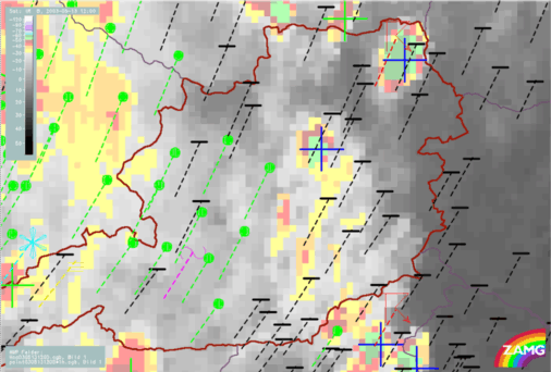
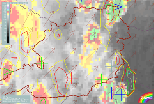
13 May 2003/11.30 UTC - Meteosat IR image; automatic cell detection (blue crosses, >: growing MCS, red
crosses: small growing cells, green crosses: large growing cells, green 0: large cell at climax, red -: small
decaying cell); radar echoes superimposed
13 May 2003/11.30 UTC - Meteosat IR image; automatic cell detection (blue crosses, >: growing MCS, red
crosses: small growing cells, green crosses: large growing cells, green 0: large cell at climax, red -: small
decaying cell), brown: AMVs; radar echoes superimposed
- Atmospheric motion vectors
- Radar motion vectors
- Tracking of cells
|
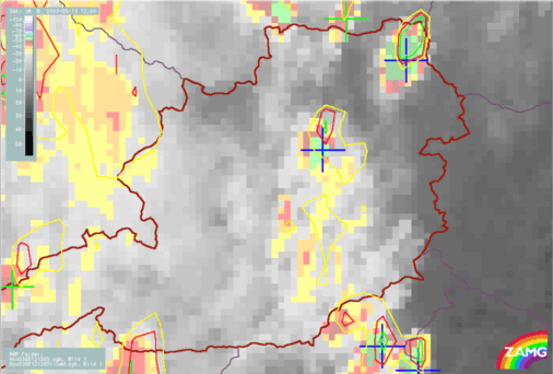
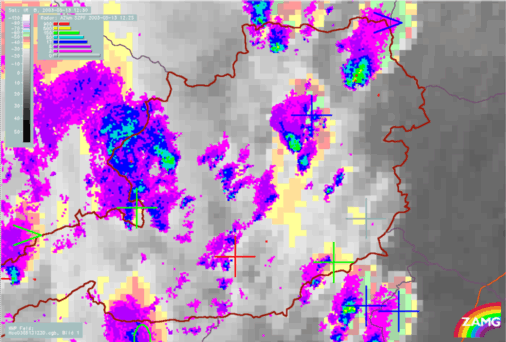
13 May 2003/12.00 UTC - Meteosat IR enhanced image; automatic cell detection (blue crosses, >: growing MCS,
red crosses: small growing cells, green crosses: large growing cells, green 0: large cell at climax, red -: small
decaying cell)
|
13 May 2003/12.00 UTC - Meteosat IR enhanced image; automatic cell detection (blue crosses, >: growing MCS,
red crosses: small growing cells, green crosses: large growing cells, green 0: large cell at climax, red -: small
decaying cell); 30min cloud top temperature forecast
|
|
|
|
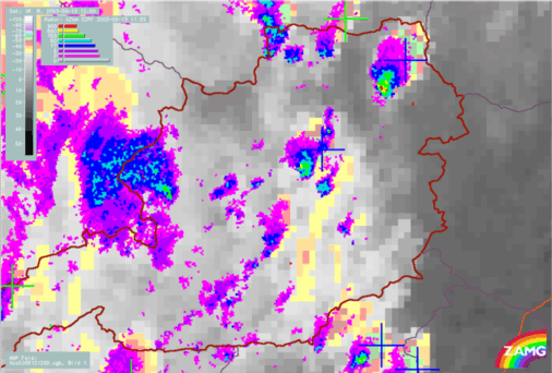
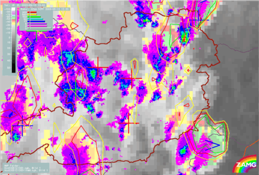
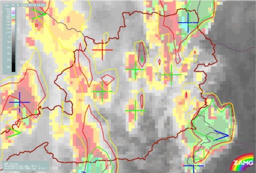
13 May 2003/12.00 UTC - Meteosat IR enhanced image; automatic cell detection (blue crosses, >: growing MCS,
red crosses: small growing cells, green crosses: large growing cells, green 0: large cell at climax, red -: small
decaying cell); radar echoes superimposed
|
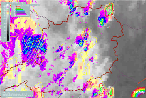
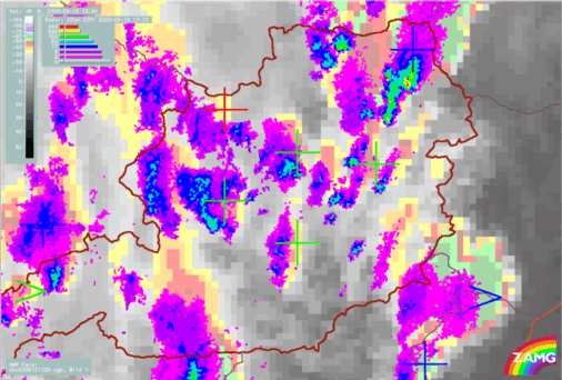
13 May 2003/12.00 UTC - Meteosat IR enhanced image; automatic cell detection (blue crosses, >: growing MCS,
red crosses: small growing cells, green crosses: large growing cells, green 0: large cell at climax, red -: small
decaying cell), orange: tracking of cells found in radar echoes, yellow: forcast of radar cells, 30min cloud
top temperature forecast; radar echoes superimposed
|
|
|
|
|
|
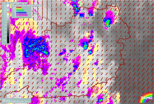
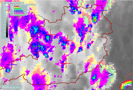
13 May 2003/12.00 UTC - Meteosat IR enhanced image; automatic cell detection (blue crosses, >: growing MCS,
red crosses: small growing cells, green crosses: large growing cells, green 0: large cell at climax, red -: small
decaying cell), brown: radar motion vectors; radar echoes superimposed
|
13 May 2003/12.00 UTC - Meteosat IR enhanced image; automatic cell detection (blue crosses, >: growing MCS,
red crosses: small growing cells, green crosses: large growing cells, green 0: large cell at climax, red -: small
decaying cell), weather events (green: rain and showers, blue: drizzle, cyan: snow, red: thunderstorm, black: no
precipitation), dashed lines: 30min weather event displacement; radar echoes superimposed
13 May 2003/12.00 UTC - Meteosat IR enhanced image; automatic cell detection (blue crosses, >: growing MCS,
red crosses: small growing cells, green crosses: large growing cells, green 0: large cell at climax, red -: small
decaying cell), brown: radar motion vectors; 30min cloud top temperature forecast; radar echoes superimposed
Weather Activity
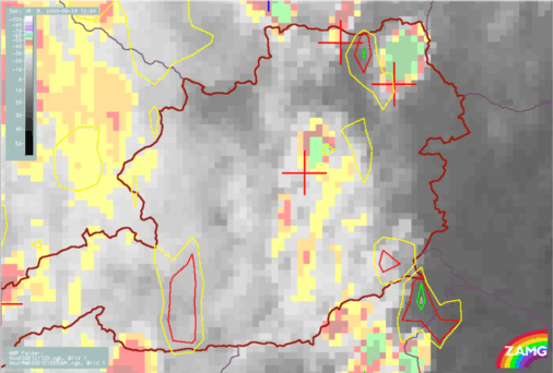
Vienna reports a thunderstorm at 12.00 UTC . It was (partly) accompanied by hail, where single hail stones had a diameter of about 5 cm. The track of the thunderstorm was to the west and north-west of Vienna with high local variability in time and intensity.The analysis of precipitation area (based upon weather reports, radar and satellite imagery) is shown below. Both cells are within the precipitation area, but it is not as extensive as seen in the satellite image (high cloudiness whithout precipitation).
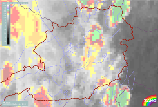
13 May 2003/12.00 UTC - Meteosat IR enhanced image; blue solid: analysis of precipitation area, blue dashed:
nowcast of precipitation area
|
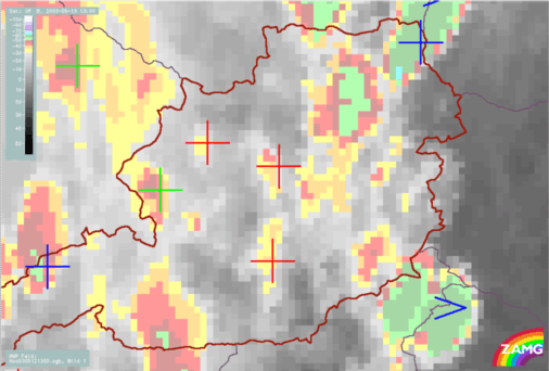
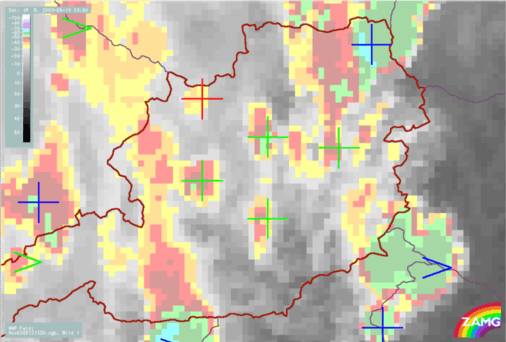
13 May 2003/12.30 UTC - Meteosat IR enhanced image; automatic cell detection (blue crosses, >: growing MCS,
red crosses: small growing cells, green crosses: large growing cells, green 0: large cell at climax, red -: small
decaying cell)
|
13 May 2003/12.30 UTC - Meteosat IR enhanced image; automatic cell detection (blue crosses, >: growing MCS,
red crosses: small growing cells, green crosses: large growing cells, green 0: large cell at climax, red -: small
decaying cell), 30min cloud top temperature forecast, brown: AMVs
|
|
|
|
|
|
13 May 2003/12.30 UTC - Meteosat IR enhanced image; automatic cell detection (blue crosses, >: growing MCS,
red crosses: small growing cells, green crosses: large growing cells, green 0: large cell at climax, red -: small
decaying cell); radar echoes superimposed
|
13 May 2003/12.30 UTC - Meteosat IR enhanced image; blue solid: analysis of precipitation area, blue dashed:
nowcast of precipitation area
|
|
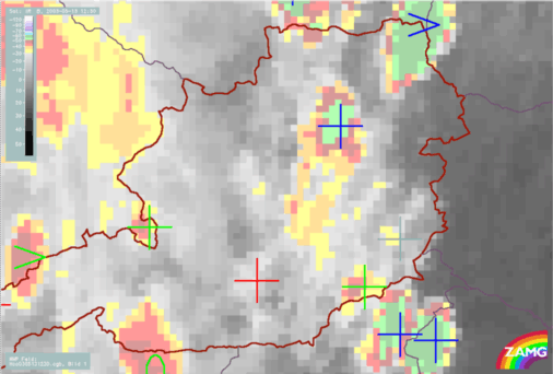
13 May 2003/13.00 UTC - Meteosat IR enhanced image;automatic cell detection (blue crosses, >: growing MCS,
red crosses: small growing cells, green crosses: large growing cells, green 0: large cell at climax, red -: small
decaying cell)
|
13 May 2003/13.00 UTC - Meteosat IR enhanced image;automatic cell detection (blue crosses, >: growing MCS,
red crosses: small growing cells, green crosses: large growing cells, green 0: large cell at climax, red -: small
decaying cell), 30min cloud top temperature forecast
|
|
|
|
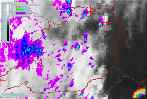
13 May 2003/13.00 UTC - Meteosat IR enhanced image; automatic cell detection (blue crosses, >: growing MCS,
red crosses: small growing cells, green crosses: large growing cells, green 0: large cell at climax, red -: small
decaying cell); radar echoes superimposed
|
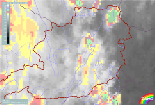
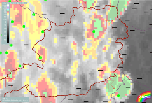
13 May 2003/13.00 UTC - Meteosat IR enhanced image; surface observations
|
|
|
|
13 May 2003/13.30 UTC - Meteosat IR enhanced image; automatic cell detection (blue crosses, >: growing MCS,
red crosses: small growing cells, green crosses: large growing cells, green 0: large cell at climax, red -: small
decaying cell)
|
13 May 2003/13.30 UTC - Meteosat IR enhanced image; automatic cell detection (blue crosses, >: growing MCS,
red crosses: small growing cells, green crosses: large growing cells, green 0: large cell at climax, red -: small
decaying cell), 30min cloud top temperature forecast
|
|
|
|
|
|
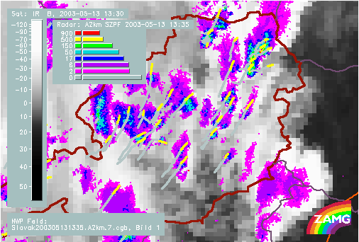
13 May 2003/13.30 UTC - Meteosat IR enhanced image; automatic cell detection (blue crosses, >: growing MCS,
red crosses: small growing cells, green crosses: large growing cells, green 0: large cell at climax, red -: small
decaying cell); radar echoes superimposed
|
Tracking of the cells
A zoom of the Vienna region shows the track of the cells analysed by radar tracking and clearly shows the path taken by the thunderstorm with hail. The highest category of radar reflectivity shows indication of hail.
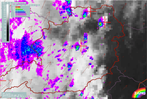
13 May 2003/13.30 UTC - Meteosat IR enhanced image; orange: tracking of cells found in radar echoes, yellow:
forcast of radar cells; radar echoes superimposed