14 - 15 JUNE 1998 - THE OBSERVATIONAL PART OF MCS DIAGNOSIS - 15 JUNE/12.00 AND 18.00 UTC
by FMI
Showalter index
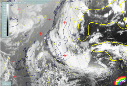
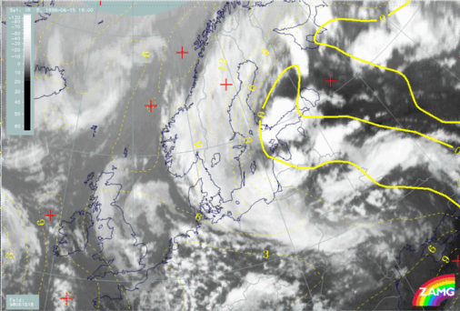
Fig. MC01 shows that the area under consideration at 12.00 UTC is under the influence of Showalter index <3 units. However, this was not the case in the area where the MCS's initially developed. By 18.00 UTC (MC02) low (below 0) the Showalter index extends along the Cold Front and fits much better with the observed convectively active areas.|
15 June 1998/12.00 UTC - Meteosat IR image; yellow: Showalter index
|
15 June 1998/18.00 UTC - Meteosat IR image; yellow: Showalter index
|
|
|
ThetaE 850 hPa
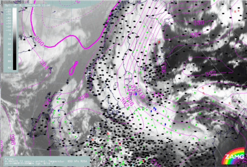
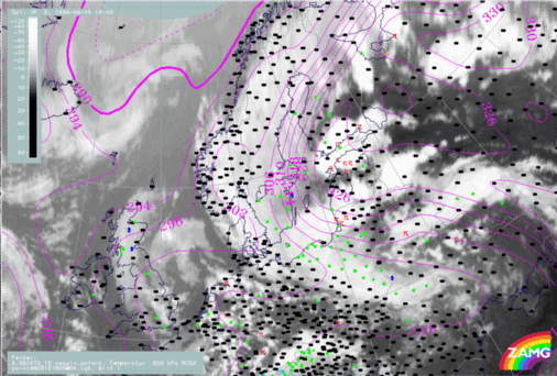
An analysis of ThetaE at 850 hPa provides better correlation with the location of initial MCS development.At 12.00 UTC (Fig. MC03) the area of development appears to be very close to the area of maximum ThetaE values (322K); a tongue of high ThetaE values are advected from the southeast towards the northeast. At 18.00 UTC (Fig. MC04) this tongue of high ThetaE values is even more evident, very high values extending up into central Finland. The isoline of ThetaE of 326K coincides remarkably well with the northern boundary of the MCS.
|
15 June 1998/12.00 UTC - Meteosat IR image; ThetaE 850 hPa, weather events (green: rain and showers, blue: drizzle, cyan: snow, red: thunderstorm
with precipitation, purple: freezing rain, orange: hail, black: no actual precipitation or thunderstorm with precipitation)
|
15 June 1998/18.00 UTC - Meteosat IR image; ThetaE 850 hPa, weather events (green: rain and showers, blue: drizzle, cyan: snow, red: thunderstorm
with precipitation, purple: freezing rain, orange: hail, black: no actual precipitation or thunderstorm with precipitation)
|
|
|
Frontal parameters and temperature advection
TFP and warm advection chart (Fig. MC05) shows the location of MCS's in respect to the approaching cold front from the south. The MCS are ideally located - just before the actual Cold Front, but clearly as separate cloud. At 12.00 UTC the young MCS seems to be located within zero temperature advection, but later in the evening they move towards an area of advection and catch up with the the Warm Front cloud band.|
15 June 1998/12.00 UTC - Meteosat IR image; blue: thermal front parameter (TFP) 500/850 hPa, green: equivalent thickness 500/850 hPa, red:
temperature advection - WA
|
15 June 1998/18.00 UTC - Meteosat IR image; blue: thermal front parameter (TFP) 500/850 hPa, green: equivalent thickness 500/850 hPa, red:
temperature advection - WA
|

|

|
Vertical Cross sections
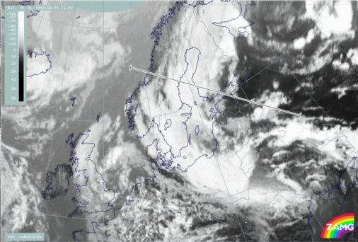
The vertical cross sections shown below are oriented from east to west. The exact location of the cross section is shown in Fig. MC07. Only 12.00 UTC cross sections are shown; cross sections at 18.00 UTC are very similar.
15 June 1998/12.00 UTC - Meteosat IR image; position of vertical cross section indicated
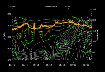
The distribution of convergence (Fig. MC09) is less typical, because convergence is found only in middle layers, not in lower layers.
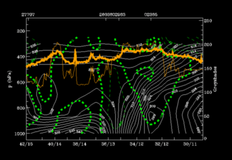
PVA (Fig. MC10) appears to have no impact on the development of MCS.
|
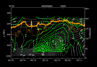
15 June 1998/12.00 UTC - Vertical cross section; white: isentropes (ThetaE), green thin: temperature advection - CA, green thick: temperature advection
- WA, orange thin: IR pixel values, orange thick: WV pixel values
|
15 June 1998/12.00 UTC - Vertical cross section; white: isentropes (ThetaE), green thin: divergence, green thick: convergence, orange thin: IR pixel
values, orange thick: WV pixel values
|
|
|
|
|
|
15 June 1998/12.00 UTC - Vertical cross section; white: isentropes (ThetaE), green thick: vorticity advection - PVA, green thin: vorticity
advection - NVA, orange thin: IR pixel values, orange thick: WV pixel values
|


