12 - 13 NOVEMBER 1997 - OVERVIEW AND FRONTAL SITUATION
by ZAMG
|
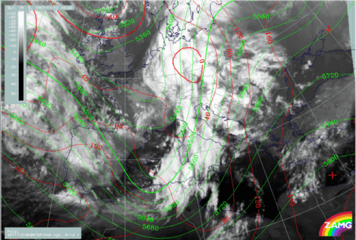
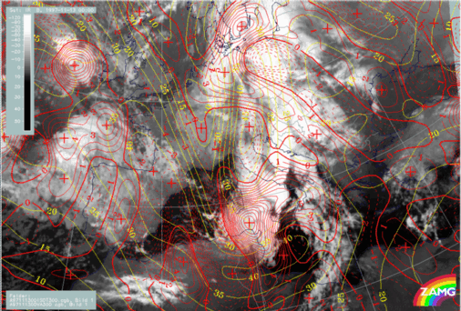
12 November 1997/18.00 UTC - Meteosat IR image; red: height contours 1000 hPa, green: height contours 500 hPa
|
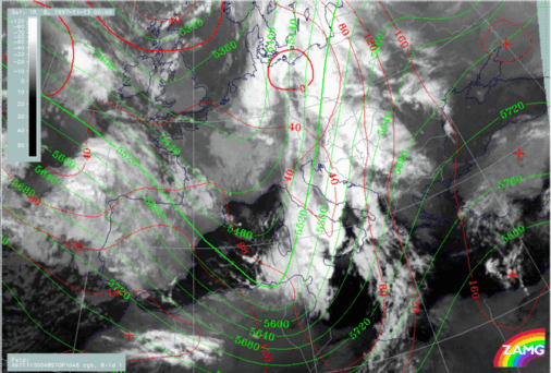
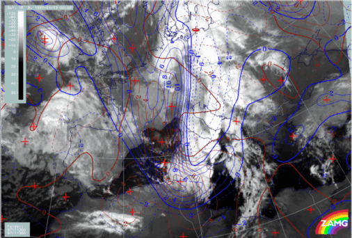
13 November 1997/00.00 UTC - Meteosat IR image; red: height contours 1000 hPa, green: height contours 500 hPa
|
|
|
13 November 1997/00.00 UTC - Meteosat IR image; blue: thermal front parameter (TFP) 500/850 hPa, green: equivalent thickness 500/850 hPa, red:
temperature advection - WA 1000 hPa
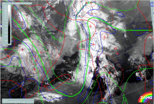
The maximum line of the TFP, which represents the conventional front line, extends from north Tunisia across the Adriatic Sea and west Croatia to west Hungary and further northward. It is accompanied from Sicily northward as far as Croatia by extensive Cb and MCS developments. These will be discussed together with the synoptic environment in a separate chapter (compare Development of Thunderstorms and MCSs During the Whole Period).
|
13 November 1997/00.00 UTC - Meteosat IR image; yellow: isotachs 300 hPa, red: vorticity advection 300 hPa
|
13 November 1997/00.00 UTC - Meteosat IR image; blue: shear vorticity 300 hPa, brown: curvature vorticity 300 hPa
|
|
|
|
|
|
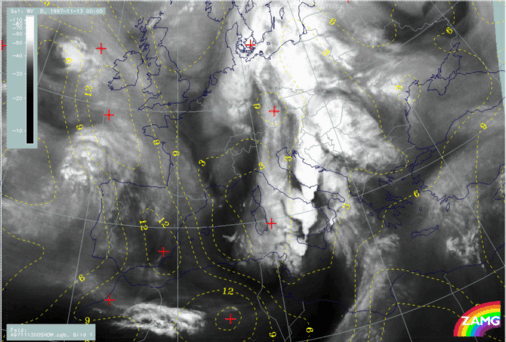
13 November 1997/00.00 UTC - Meteosat WV image; yellow: Showalter index 500/850 hPa
|
- There is still a huge PVA maximum superimposed on the front between Tunisia and Sardinia which is now produced by both the shear in the left exit region and the curvature in the pronounced upper level trough (right image top);
- But as a continuation from six hours earlier, a second jet streak has developed which extends from Tunisia eastward; it seems to be responsible for
two effects:
- Dry air propagating ahead of the Cold Front and causing the very black area in the WV image there (left image bottom)
- A lobe of PVA extending from approximately 39N/12E - south Italy which is in the left exit region of the new jet streak and mainly caused by shear (right image top).
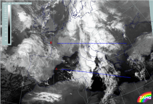
13 November 1997/00.00 UTC - Meteosat IR image; position of vertical cross sections R and S indicated
|
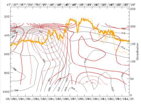
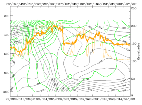
13 November 1997/00.00 UTC - Vertical cross section R; black: isentropes (ThetaE), red thin: temperature advection - CA, red thick: temperature
advection - WA, orange thin: IR pixel values, orange thick: WV pixel values
|
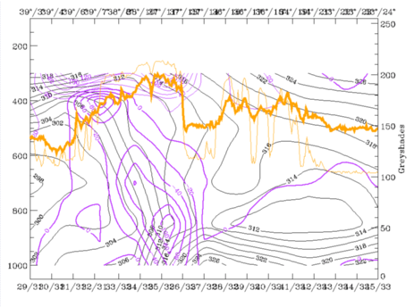
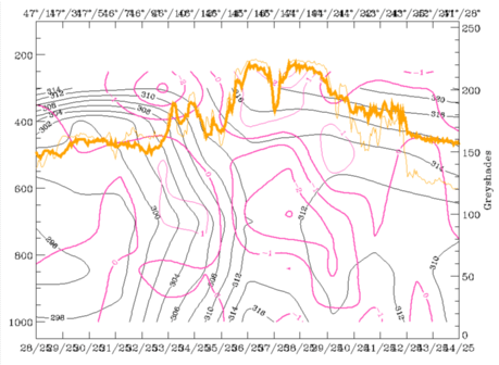
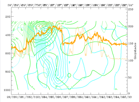
13 November 1997/00.00 UTC - Vertical cross section R; black: isentropes (ThetaE), magenta thin: divergence, magenta thick: convergence, orange
thin: IR pixel values, orange thick: WV pixel values
|
|
|
|
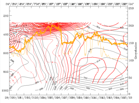
13 November 1997/00.00 UTC - Vertical cross section S; black: isentropes (ThetaE), red thin: temperature advection - CA, red thick: temperature
advection - WA, orange thin: IR pixel values, orange thick: WV pixel values
|
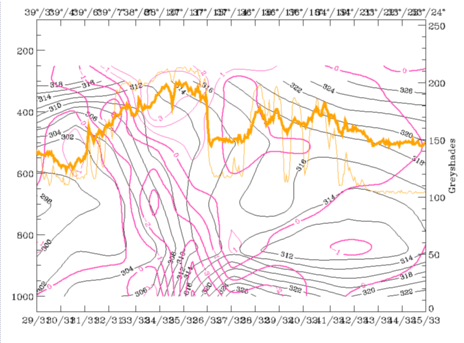
13 November 1997/00.00 UTC - Vertical cross section S; black: isentropes (ThetaE), magenta thin: divergence, magenta thick: convergence, orange
thin: IR pixel values, orange thick: WV pixel values
|
|
|
|
13 November 1997/00.00 UTC - Vertical cross section S; black: isentropes (ThetaE), green thick: vorticity advection - PVA, green thin: vorticity
advection - NVA, orange thin: IR pixel values, orange thick: WV pixel values
|
13 November 1997/00.00 UTC - Vertical cross section S; cyan thick: vertical motion (omega) - upward motion, cyan thin: vertical motion (omega) -
downward motion, green thick: vorticity advection - PVA, green thin: vorticity advection - NVA, orange thin: IR pixel values, orange thick: WV
pixel values
|
|
|
13 November 1997/00.00 UTC - Vertical cross section; black: isentropes (ThetaE), lilac: Q-Vector (normal component), orange thin: IR pixel values,
orange thick: WV pixel values