24 - 25 AUGUST 1997 - DEVELOPMENT BETWEEN 18.00 AND 00.00 UTC
by KNMI
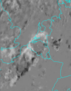
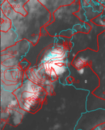
This deviation values can also be calculated. Positive values denote developing cloudiness, negative values dissolving cloudiness.
|
24 August 1997/20.00 - 21.00 UTC - Meteosat IR development image
|
24 August 1997/21.00 UTC - Meteosat IR image; red: mean values of grey shades of cloud development and decay
|
|
|
Radiosonde Soundings
Soundings from radiosondes are very helpful in detecting an unstable air mass.They have the advantage of giving a true picture of the state of the atmosphere, more so than model fields. A disadvantage is the fact that they represent only a one dimensional state of the atmosphere. To make use of these soundings one must assume that the data are representative of the whole air mass.
24 August 1997/18.00 UTC - Radiosounding De Bilt (06260)
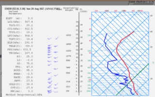
Also the amount of precipitable water (PW), 3.3 cm, is very high.


