29 JULY 1997 - DIAGNOSIS FOR 06.00 UTC WITH HELP OF VERTICAL CROSS SECTIONS
by ZAMG
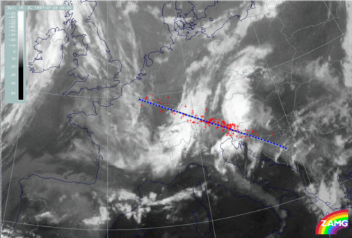
29 July 1997/06.00 UTC - Meteosat IR image; red: weather observation stations; position of vertical cross section indicated
|
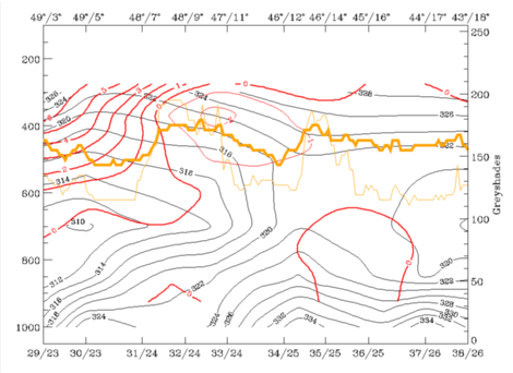
29 July 1997/06.00 UTC - Vertical cross section; black: isentropes (ThetaE), red thin: temperature advection - CA, red thick: temperature
advection - WA, orange thin: IR pixel values, orange thick: WV pixel values
|
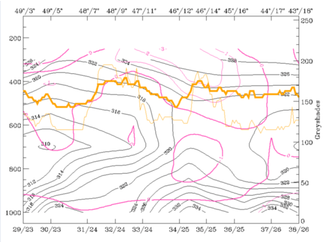
29 July 1997/06.00 UTC - Vertical cross section; black: isentropes (ThetaE), magenta thin: divergence, magenta thick: convergence, orange thin:
IR pixel values, orange thick: WV pixel values
|
|
|
|
|
|
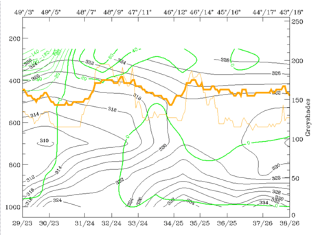
29 July 1997/06.00 UTC - Vertical cross section; black: isentropes (ThetaE), green thick: vorticity advection - PVA, green thin: vorticity
advection - NVA, orange thin: IR pixel values, orange thick: WV pixel values
|
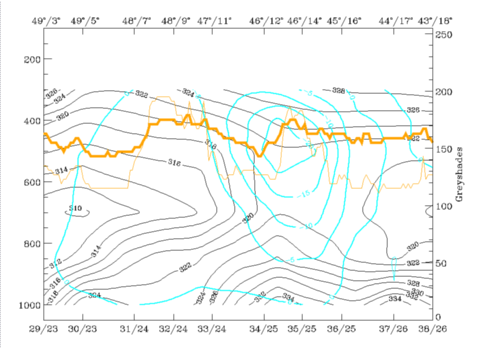
29 July 1997/06.00 UTC - Vertical cross section; cyan thick: vertical motion (omega) - upward motion, cyan thin: vertical motion (omega) -
downward motion, magenta thin: divergence, magenta thick: convergence, orange thin: IR pixel values, orange thick: WV pixel values
pixel values
|
- There is no notable temperature advection in the top left image, especially in the eastern system, but two interesting facts can be recognised:
- In the eastern system where there are thunderstorm events there is (weak) WA below and CA above, which is a typical configuration for instability
- The western system is under CA between 500 and 300 hPa, which fits well to the upper level trough situation described before.
- Both cloud systems are accompanied by configurations of isentropes which are typical for a very unstable troposphere; although isentropes do not reveal any normal frontal characteristics, there is a suggestion of a weak upper level Cold Front inclined downward from 300 to 400 hPa between the two cloud systems.
- Both cloud systems are also accompanied by convergence in a thick layer (right image top). In particular the eastern cloudiness, the Convergence Cloudiness (compare Conceptual Models: Convergence Cloudiness ), shows appreciable convergence between 900 and 500 hPa.
- A maximum of PVA at 300 hPa (left image bottom) is superimposed on the western cloud system and represents the PVA in the left exit region of the jet streak discussed in more detail previously (compare Diagnosis of the eastern cloud feature - Conceptual models "Convergence Cloudiness" and "Cumulonimbus (Cb) and Mesoscale Convective System (MCS)" and Conceptual Models: Front Intensification by Jet Crossing ).
- Although the whole area is an area of upward motion (right image bottom: negative values of omega) the main rising happens at this point of time with the eastern system in connection within the convergence there.


