27 - 29 January 2004 - Analysis for 28 January 2004
by KNMI
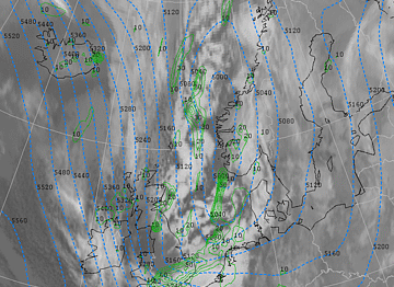
28 January 2004 00.00 UTC
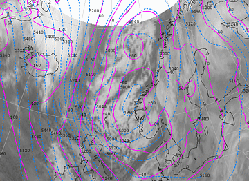
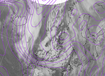
28 January 2004/00.00 UTC - Meteosat IR image; cyan: height contours 500 hPa, magenta: height contours 1000 hPa
There are now three separate low-pressure centres. The lowest pressure is about 987 hPa. On the left side of the
cloudiness we see several small vortices that subsequently grow further into two polar lows. The low-level trough is
difficult to recognize on the picture above, but it lies ahead of a clearly visible upper-level trough at 500 hPa. The
small vortex that developed in the band of cloudiness associated with the trough from Norway to England is now visible
above the North Sea. The trough is followed by a sharp-bordered stroke of spells.
28 January 2004/00.00 UTC - Meteosat IR image; purple: ThetaW 850 hPa
The position of the arctic front is clearly visible on the picture above. The strong gradient in Θ
W at 850 hPa lies near the front of the cloudiness.
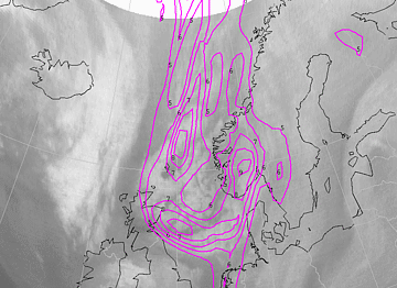
28 January 2004/00.00 UTC - Meteosat WV image; magenta: potential vorticity 303K
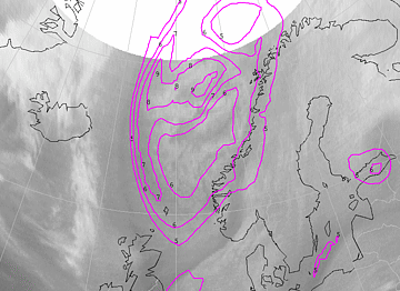
In the developing phase of a Polar Low a maximum in potential vorticity (PV) is often found upstream of the low. In this
case there is a very large area of PV (higher than 5 units) in the upper part of the troposphere (at 303K) at a position corresponding to the area of cloudiness. A maximum of 8 PVU is found northwards of the most northern vortex.
28 January 2004 06.00 UTC
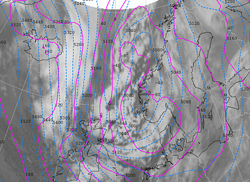
28 January 2004/06.00 UTC - Meteosat IR image; cyan: height contours 500 hPa, magenta: height contours 1000 hPa
The steering low-pressure area has moved further southwards, and the low-pressure area did not deepen further. The small
vortex above the North Sea has moved southeastwards and lies near the Dutch coast. It can just be seen on the
infrared satellite pictures. The accompanying band of cloudiness where the vortex developed, dissolves quickly and
eventually largely disappears.
28 January 2004/06.00 UTC - Meteosat IR image; magenta: ThetaW 850 hPa
The strong gradient in the Θ
W at 850 hPa decreases as the Arctic Front moves further south.
A Polar Low is situated north of the Shetland Islands (62N/02W) and a second Polar Low vortex can be seen at 67N/02E,
between Iceland and Norway.
28 January 2004 12.00 UTC
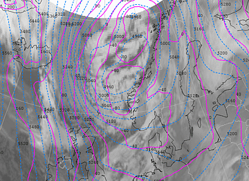
28 January 2004/12.00 UTC - Meteosat IR image; cyan: height contours 500 hPa, magenta: height contours 1000 hPa
In the meantime, the clouds of the Arctic Front have moved southwards into the North Sea and the centre of the main depression is situated over southern Norway. The arctic front coincides with the low-level trough and is followed by an upper-level trough at 500 hPa. The Arctic Front, which lies from Norway, the British Islands towards Iceland, is clearly visible through its cloudiness, except for the part above the British Isles (see also image of Θ
W at 850 hPa below).
28 January 2004/12.00 UTC - Meteosat IR image magenta: ThetaW 850 hPa
The first Polar Low has passed the Shetlands and is heading for Scotland. It seems that the second Polar Low further north disappears between 08.00 and 11.00 UTC. But from 12.00 UTC, the vortex clearly exists once again.
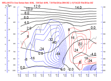
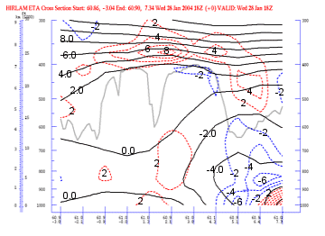
28 January 2004/12.00 UTC - Vertical cross section; black: isentropes (ThetaW), grey: satellite signal
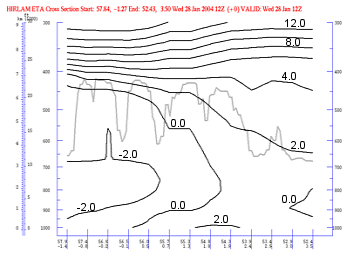
This vertical cross section is made perpendicular to the arctic front, from northwest to southeast. The arctic front is
easily recognized in the bending of the isentropes. The corresponding satellite signal clearly reveals the position of the clouds. Higher values of satellite signal result from a whiter colour and higher cloud tops. The Arctic Front is visible up to about 450 hPa.
28 January 2004/12.00 UTC - Meteosat IR image; yellow: vertical motion (omega) 850 hPa
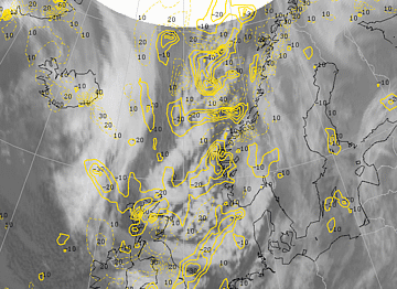
Negative omega values (ascending air) lie over the cloud areas of the two Polar Lows. The Polar Low close to Scotland is surrounded by positive values of omega. The second Polar Low has the strongest negative values and therefore the strongest upward motion.
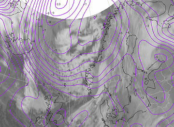
28 January 2004/12.00 UTC - Meteosat WV image; magenta: potential vorticity 303K
The area with PV-values exceeding 5 units at the level of 303 Kelvin covers approximately the whole area west of the
Norwegian coast and the North Sea. A maximum of 9 units (or PVU) can be found between the two Polar Lows. This value decreases until 18.00 UTC on 29 January 2004, but at the position of the northern Polar Low it remains above 5 PVU.
28 January 2004 18.00 UTC
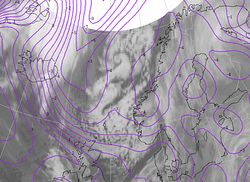
28 January 2004/18.00 UTC - Meteosat IR image; cyan: height contours 500 hPa, green: positive vorticity
advection (PVA) 500 hPa
The centre of the steering depression has moved a bit southwards and the surface pressure at the centre is unchanged. The Polar Low near Scotland has moved towards the North Sea but has lost its identity, while the second, now between Norway and the Shetland Isles has developed into a pronounced vortex and is moving further southwards. This vortex lies in front of a shallow upper trough with an extended are of PVA. Areas with positive vorticity values up to 30 units can be found over the North Sea near the cloud clusters of the former Polar Low.
|
28 January 2004/18.00 UTC - Vertical cross section; black: isentropes (ThetaW), red: vertical motion (omega) -
downward motion, blue: vertical motion (omega) - upward motion, grey: satellite signal
|
28 January 2004/18.00 UTC - Meteosat IR image; position of vertical cross section indicated
|
|
|
|
The centre of the Polar Low can be found at approximately 61N/2E in this vertical cross section from west (61N/3W) to east (61N/7E). The vertical cross section shows omega, Θ
W and the satellite signal. The satellite signal clearly reveals the nearly cloudless area west of the polar low (low satellite signal value), then a band of cloudiness (high value), followed by miscellaneous clouds round the core of the Polar Low and, finally, the cloudless area west of the Norwegian coast. Strong ascent characterizes the area of the centre (negative values of omega).
28 January 2004/18.00 UTC - Vertical cross section; black: isentropes (ThetaW), blue: temperature advection -
CA, red: temperature advection - WA, grey: satellite signal
The vertical cross section above shows the advection of temperature, Θ
W and the satellite signal. At the position of the Polar Low (61N/2E) warm air advection is found in the lower levels (up to 600 hPa) and cold advection above that level. This combination will lead to a stronger temperature contrast and destabilisation of the air mass, with a possible, subsequent intensification of the Polar Low.