27 - 29 January 2004 - Description of the Synoptic Situation
by KNMI
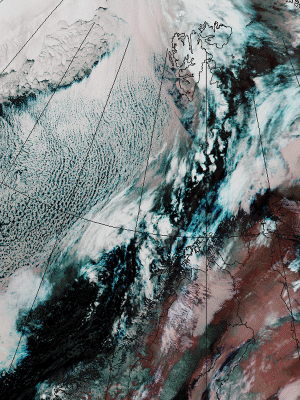
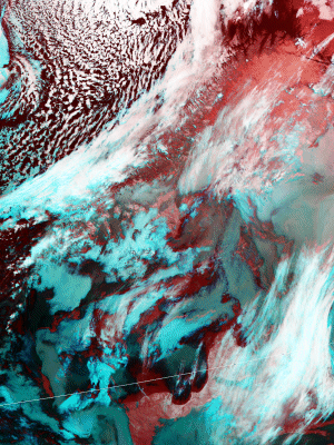
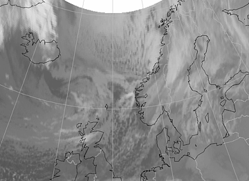
The satellite images of 25 January and 26 January show an extended area of Cloud Streets over the extreme north of the
Atlantic, situated in an arctic air flown out from the mainland of Greenland. These images are NOAA high-resolution images, more specifically, a combination of the 3, 4 and 5 channels. Over the sea, in the area southeast of Greenland, the convective Cloud Streets lie in the direction of the outflow. The convective cloud streets are preceded by an Arctic Front. The Polar Low eventually develops in this air mass behind the arctic front.
|
25 January 2004/20.27 UTC - NOAA RGB image (channel 3, 4 and 5)
|
26 January 2004/11.52 UTC - NOAA RGB image (channel 3, 4 and 5)
|
|
|
|
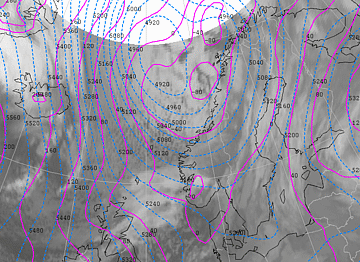
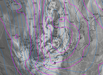
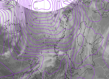
On 27 January 00.00 UTC there is an area of high pressure west of Ireland with a core pressure of 1030 hPa. At 500 hPa there are also high height values at almost the same position. There being a well developed low-pressure area north of Scandinavia, a northerly flow starts between Iceland and Norway, which transports arctic air southwards. On 28 and 29 January the high-pressure area slowly recedes southwards to the Azores, but there is still a strong ridge present in the direction of Greenland. The depression moves from the Norwegian coast to Denmark. The northerly flow persits for three days because of this situation. In the course of 29 January the flow gradually starts backing.
|
27 January 2004/12.00 UTC - Meteosat IR image; cyan: height contours 500 hPa, magenta: height contours 1000 hPa
|
28 January 2004/18.00 UTC - Meteosat IR image; cyan: height contours 500 hPa, magenta: height contours 1000 hPa
|
|
|
|
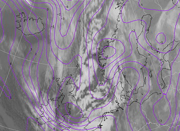
Initially, the polar front lies from the Balkans, over Italy, northern Spain and the Atlantic Ocean. Over the next days the northerly flow over western Europe pushed the polar front further south, reaching northern Africa. The extremely cold arctic air coming directly from the North Pole is marked by the arctic front. On 27 January 12.00 UTC the most southern part of this arctic front lies between Iceland and Norway. In the next days the arctic front slowly moves southwards over the North Sea. The sharp temperature gradient at the beginning of this situation (27-1-04 12.00 UTC) weakens steadily as the arctic front moves southwards (28-1-2004 18.00 UTC). Warming of the lower layers occurs due to the warming by the sea.
|
27 January 2004/12.00 UTC - Meteosat IR image; magenta: ThetaW 850 hPa
|
28 January 2004/18.00 UTC - Meteosat IR image; magenta: ThetaW 850 hPa
|
|
|
|
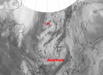
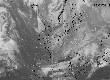
The infrared satellite pictures of 27 January 02.00 UTC show typical convective cloudiness (many white spots) of an outbreak of cold air, to the northwest of Norway. The convective cloudiness moves southwards and begins to rotate cyclonically.
27 January 2004/02.00 UTC - Meteosat IR image
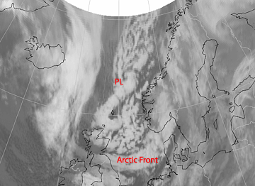
From the outset (27-1-04 00.00 UTC), the white spots grow quickly whiter and larger. This indicates fast growing, convective cloudiness. From 12.00 UTC on, the white spots start to merge together and the cloudiness starts to rotate. During the night of 28 January the arctic front (AF), preceding the arctic air, develop into a more distinct feature on the infrared satellite pictures. In the course of the night several curls can be seen which jointed together like an S-shaped spiral. These are located on the left side of the area of cloudiness and move towards Scotland (28 January 12.00 UTC). Once the first curl arrives there, it disappears. Wind gusts accompanying this curl reach a speed of more than 60 knots.
|
28 January 2004/06.00 UTC - Meteosat IR image
|
28 January 2004/12.00 UTC - Meteosat IR image
|
|
|
|
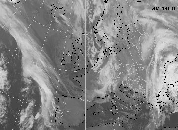
The Arctic Front (AF) merges with an area of cloudiness above Ireland and England and subsequently moves as one band of cloudiness into Western Europe. To the rear of this area, a broad band of clustered convective cloudiness appears, soon followed by the Polar Low (28 January 23.00 UTC).
The Polar Low is clearly seen on the first infrared satellite picture of 28 January 02.00 UTC. The development, however,
lies too far north and outside the view of the satellite. Around 09.00 UTC the spiral structure seems to disappear for a while. At 12.00 UTC the spiral structure returns and at 23.00 UTC it is well developed lying over the North Sea. The maximum wind gust reported at this time is 61 knots, corresponding wind force 11 on the Beaufort scale.
|
28 January 2004/02.00 UTC - Meteosat IR image
|
29 January 2004/06.00 UTC - Meteosat IR image
|
|
|
|
Above the North Sea the Polar Low turns in the direction of German Bight and moves into northern Germany and the northeastern parts of The Netherlands (29 January 06.00 UTC). The spiral structure disappears quickly and the Polar Low decays.
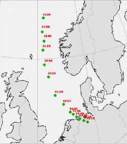
The position of the Polar Low is followed using satellite images, radar pictures and surface observations. The position of the Polar Low over time is shown in the figures beneath (29 January 12.00 UTC - 30 January 09.00 UTC in steps of two hours, and from 04.00 UTC in steps of one hour). The Polar Low moves in a straight line southwards and then turns over the North Sea, following the general flow. The Polar Low moves with a constant speed, from northwest to southeast, over the northeastern parts of The Netherlands. The core of the low makes landfall around 06.00 UTC in northwest Germany and the central pressure drops to 986 hPa. From the moment the Polar Low reaches land, the pressure slowly starts to rise and the low fills. With the approach of the polar low the wind starts to veer from southwest to northwest and increases in speed. In the northern coastal areas the northwesterly wind reaches force 8/9. The highest mean hourly wind speed is force 8. Over land the windspeed is generally force 4 to 6.
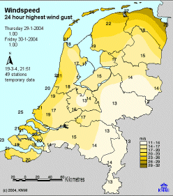
Polar Lows are often accompanied by strong wind gusts. The figure below shows an overview of the highest reported wind
gust during a period of 24 hours on 29 January. The highest wind gust was reported in Nieuw-Beerta (eastern part of Groningen): 28 m/s (force 10).
|
Position of the Polar Low from 28 January to 29 January
|
29 January 2004 - 24 hours maximum wind gusts
|
|
|
|
Surface isobar analysis shows that a meso scale low-pressure area has developed. Because there is a lack of observations
northward of the polar low it cannot be stated with full 100% certainty. The lowest measured pressure in the centre is 986 hPa. The output of the Hirlam model at 06.00 UTC does not show a separate low-pressure area at the surface, but a sharp trough. The model pressure at the position of the Polar Low is overestimated by approximately 6 hPa. The consequence of this overestimation has a significant impact on the wind forecast. The lack of such a strong pressure drop over a short period of time and at a small horizontal scale causes a significant underestimation of the wind. Wind speed and wind gusts turned out to be much higher than forecasted by the model.
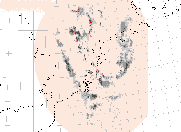
The vortex can also be detected clearly on radar pictures. The intensity of the low decreases rapidly and the structure
disappears after landfall (see pictures below). Showers are observed throughout the rest of the day from the North Sea area, but the number and intensity of the showers gradually declines.
|
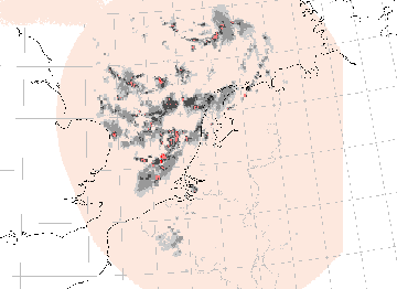
29 January 2004/03.00 UTC - Radar image
|
29 January 2004/07.00 UTC - Radar image
|
|
|
|
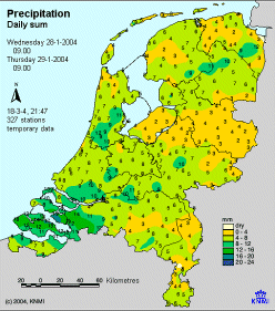
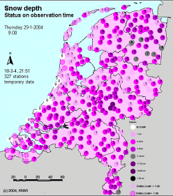
The northern part of The Netherlands is, to a large extent, free of snow on 28 January 09.00. There is only some snow in coastal areas, but the snow depth doesn’t exceed one centimetre. On Wednesday 28 January, during late afternoon and early evening (from about 17.00), an extensive area of precipitation moves eastwards over northern Netherlands. The precipitation starts to fall as rain, but quickly turns to snow. The temperatures which is +1 degree Celsius at the end of the afternoon, falls to -1 degree by the beginning of the evening. The wind veers from southwest to northwest. From 22.00 on it is dry and, for the greater part, cloud free. The temperature reaches its minimum of -5° Celsius at 02.00hr. From this moment on the temperature slowly increases, due to the veering of the wind in a direction from which the air is brought down over sea. The freezing point isotherm reaches the coastal areas at 04.00, but then slowly pulls back in a southeastwards direction. At 09.00hr the temperature in the eastern parts of the northeastern provinces of Groningen and Drenthe is still around freezing level. At 05.00 the first snow showers of the Polar Low move into the northern parts of the Netherlands. The heaviest showers are located south of the low where especially in the northern province of Friesland, there is heavy showers and thunderstorms. The northwestern parts of Germany also report thunderstorms. By landfall the precipitation intensity is decreasing. The last snow showers leave the Netherlands around 08.00hr. The snowfall caused by the Polar Low reached the province of Overijssel, south of Drenthe. Most stations in northern Netherlands report 4 to 7 millimetre of precipitation (ending on 29 January at 09.00). High 24 hours precipitation amounts can be found from southeast-Friesland towards Drenthe and southeast-Groningen (see left figure below). The figure below on the right shows the snow depth at 29 January 09.00. It clearly shows that the coastal zones of Friesland and Overijssel have less snow than Drenthe and Groningen. Higher temperatures is the cause of this, with melting snow, but also the direction of movement and the decreasing intensity of the showers. The largest part of southeast-Friesland, Drenthe and southeast-Groningen report a snow depth of at least 5 cm. Winschoten (east-Groningen) has the highest snow depth: 11 cm. As mentioned before the Polar Low is not the only cause of this snow, but it also came from the Arctic Front that passed over the region the previous evening.
|
29 January 2004/09.00 UTC - Observed sum of 24 hours precipitation
|
29 January 2004/09.00 UTC - Observed snow depths
|
|
|
|