Convective Cloud Features In Typical Synoptic Environments: The Spanish Plume - Meteorological Physical Background
by FMI
|
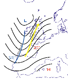
Upper-level flow within Spanish plume. Solid lines: upper level (500 or 300 hPa) geopotential height; blue solid line: the upper trough; yellow
arrow: jet stream axis
|
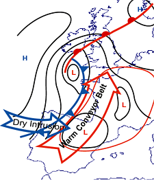
Low-level flow within Spanish plume. Open red arrow: the warm conveyor belt; open blue arrow: the dry intrusion. Area within red solid line: a
typical area of high ThetaE values at 850 hPa. Black solid lines: surface isobars. Classical surface fronts also shown
|
|
|
The approaching Cold Front has an important role in the further development of the Spanish Plume in two ways:
- As the front approaches the continent, the existing thermal gradient intensifies. This causes the strengthening of winds ahead of the upper-level trough and wind adjustment in the lower levels; consequently an intensification of warm air advection and ascent within the warm plume ahead of the surface trough takes place (Phase C).
- The possible over-running of cold air at upper levels from behind the front, and further destabilization of the already highly unstable air within the Spanish Plume, can trigger deep convection.
|
|
|
The example below illustrates this process: a Cold Front approaching from the west gradually loses its intensity (as seen by a steady and later decreasing gradient of isentropes), while in the area of the Spanish Plume the ThetaE gradient increases and the Cold Front actually seems to "jump" forward.
|
03 July 2005/18.00 UTC - Meteosat 8 IR10.8 image; green: equivalent thickness, magenta: Equivalent potential temperature 850 hPa
|
04 July 2005/00.00 UTC - Meteosat 8 IR10.8 image; green: equivalent thickness, magenta: Equivalent potential temperature 850 hPa
|

|

|

|
|
|
04 July 2005/06.00 UTC - Meteosat 8 IR10.8 image; green: equivalent thickness, magenta: Equivalent potential temperature 850 hPa
|
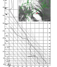
Stability (soundings)
The pronounced instability at low and middle levels is clearly seen in the soundings. Often there is a lid of warm air near 850 hPa level. This lid delays the initiation of surface-based convection. Consequently, Convective Available Potential Energy (CAPE) is stored until it is released either by thermal advection or ascending motion. The triggering is often explosive, and can result in severe thunderstorms.Cooling aloft, ahead of the advancing upper-level trough, and heating from below due to warm advection and solar insolation further destabilizes the atmosphere.
The amount of potential instability increases remarkably when the low-level moist air is capped by significantly drier air at medium levels (400-600 hPa). Upper-level dry air intrusion from behind may support explosive convection once convection is initiated.
The wind often veers considerably with height, which means a moist south-southeasterly flow at low levels, and a steady or increasingly south-westerly flow at middle and upper levels.