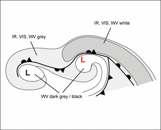
Secondary Low Centres In Occlusion Cloud Bands - Cloud Structure In Satellite Images
by FMI
The formation of a Secondary Low can be seen in a series of satellite images:
- Initially the cloudiness thickens, and the whole front seems to be undulating.
- In the developement stage a cloud vortex appears, rotating cyclonically around the secondary low.
- In the mature stage there are two separate cloud spirals curling around the lows.
- Visible images are rarely of use, because Secondary Lows within occluded fronts develop mostly over the Northern Atlantic during the winter season, and the time of daylight is short.
- In infrared images a white to light grey multilayered cloud spiral develops
- In water vapour images a white to light grey cloud spiral develops around the Secondary Low. Additionally, there is usually a Dark Eye over it, and a Dark Stripe behind the Cold Front and forward of the Occluded Front.
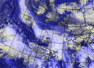
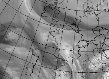
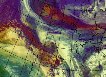
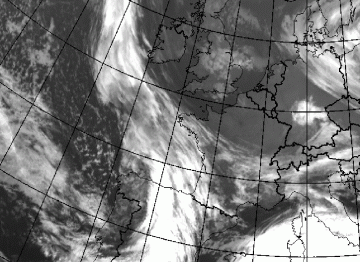
On the 17th of April 2008 at 12.00 UTC there is an occluded front reaching from the Atlantic Ocean to France. The original low is located southwest of Ireland, the secondary has developed over the Bay of Biscay:
|
|
|
|
|
17 April 2008/12.00 UTC - Meteosat 9 WV image
|
17 April 2008/12.00 UTC - Meteosat 9 HRVIS IR image
|
|
17 April 2008/12.00 UTC - Meteosat 9 air mass image
|
17 April 2008/00.00 UTC - Meteosat 9 IR image
|
|
|

