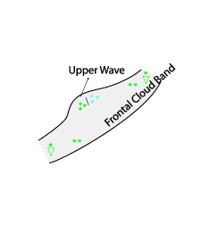
Upper Wave - Weather Events
by ZAMG
| Parameter | Description |
| Precipitation | No precipitation under the Wave bulge. Precipitation pattern according to a Cold Front |
| Temperature | Changes according to frontal passage |
| Wind (incl. gusts) | Changes according to frontal passage |
| Other relevant information |
|
|
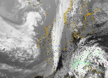
22 August 2005/12.00 UTC - Meteosat 8 IR 10.8 image; weather events (green: rain and showers, blue: drizzle, cyan: snow, red: thunderstorm, yellow:
fog, black: no precipitation)
|
|
|
|


