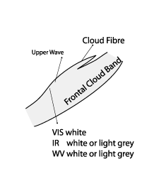
Upper Wave - Cloud Structure In Satellite Images
by ZAMG
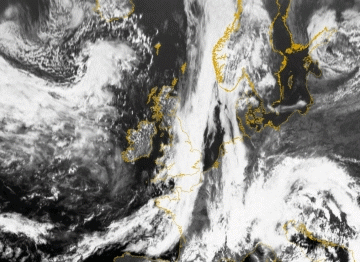
Appearance in METEOSAT 8 imagery
- IR 10.8 imagery
- Convex cloud bulge at the rear of a frontal cloud band, often large elongation of cloud bulge
- Grey to white due to high level cloudiness, Wave bulge appears brighter than the surrounding frontal clouds
- Sharp edge to the cold air behind the front
- Fibres indicating strong upper winds or jet streak
- WV 6.2 imagery:
- Bright grey or white due to height of cloud bulge, which appears more enhanced (brighter) in relation to surrounding frontal cloud band
- Sharp edge to the black dry zone to the rear of the front
- WV dark zone at rear indicating sinking of dry air from the stratosphere
- VIS 0.6 imagery:
- White due to thickness of cloud bulge
- Fibre - like character due to high clouds
At first sight the upper wave seems to look similar to a classical wave but more detailed study shows differences (see Wave ):
- Often the Upper Wave bulge as seen in satellite imagery is less pronounced than the "classical" Wave
- There is generally less amplification than with a "classical" Wave
- An Upper Wave propagates rapidly along the rear side of the frontal cloudband
- In an Upper Wave there is often a fibre cloud indicating strong upper level winds (schematic below)
|
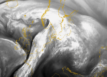
16 March 2005/18.00 UTC - Meteosat 8 IR 10.8 image
|
16 March 2005/18.00 UTC - Meteosat 8 WV 6.2 image
|

|
|
|
|
|
16 March 2005/16.00 UTC - Meteosat 8 VIS 0.6 image
|
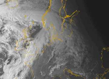
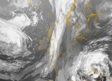
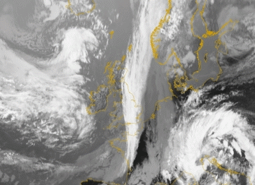
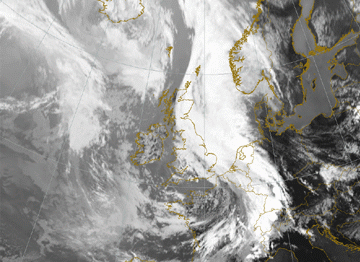
A second case of an Upper Wave is shown below (22 August 2005 at 12.00 UTC). The cloud bulge extends over Eastern England. The presence of the jet can be seen very well in both the IR 10.8 as well as the WV 6.2 (below left and right). The Wave feature is also much distinct, whereas the VIS 0.6 image (2nd row below left) clearly shows the fibrous clouds within the enhanced Wave bulge of upper level cloudiness.
|
22 August 2005/12.00 UTC - Meteosat 8 IR 10.8 image
|
22 August 2005/12.00 UTC - Meteosat 8 WV 6.2 image
|

|
|
|
|
|
22 August 2005/12.00 UTC - Meteosat 8 VIS 0.6 image
|
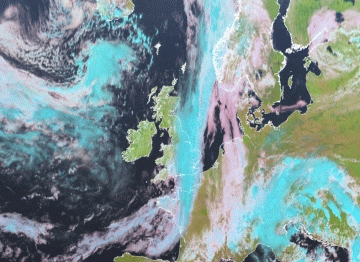
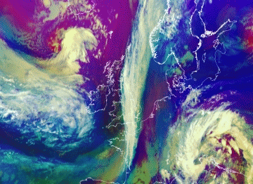
A second RGB consists of NIR 1.6, VIS 0.8 and VIS 0.6. In this so-called natural colour RGB the fibrous character of the upper Wave is well observed.
|
22 August 2005/12.00 UTC - Meteosat 8 Airmass RGB image (WV6.2-WV7.3, IR9.7-IR10.8 and WV6.2i)
|
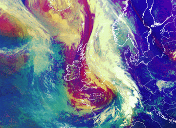
22 August 2005/12.00 UTC - Meteosat 8 RGB image (NIR1.6, VIS0.8 and VIS0.6)
|

|
|
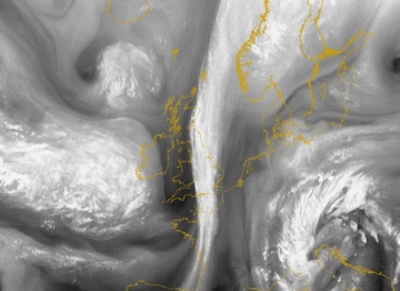
The loop below shows the fast propagation of the Upper Wave bulge along the frontal cloud band (22 August 2005 06.00 UTC to 23 August 2005 00.00 UTC). During the whole life cycle of the Upper Wave, there is no further development, such as amplification or enhancement of the cloud bulge. The amplitude of the upper wave even becomes less due to an oncoming depression moving in between Iceland and Scotland.
Distinction between Wave and Upper Wave according to appearance in satellite images
| Upper Wave | Wave |
|---|---|
| More elongated flat cloud bulge | Distinct, more amplified cloud bulge |
| Sharp edge to the rear; also fibre cloud | Less fibre cloud |
| Multilayered or high non convective cloudiness | Multilayered cloudiness, convective cells embedded |
| Distinct, relatively fast propagation along the rear of the frontal cloud band | Slow propagation, possible further cyclogenesis |
|
22 August 2005/12.00 UTC - Meteosat 8 IR 10.8 image
|
04 July 2005/12.00 UTC - Meteosat 8 IR 10.8 image
|
|
|
|
|
|
22 August 2005/12.00 UTC - Meteosat 8 Airmass RGB image (WV6.2-WV7.3, IR9.7-IR10.8 and WV6.2i)
|
04 July 2005/12.00 UTC - Meteosat 8 Airmass RGB image (WV6.2-WV7.3, IR9.7-IR10.8 and WV6.2i)
|

