Upper Wave - Special Investigation: Can An Upper Wave Develop Into A Wave?
by ZAMG
From the point of view of key parameters and vertical cross sections, only a few parameters show a complete change into a "classic" Wave. That means that Upper Waves tend to adopt single Wave - like characteristics, e.g. amplification of the Wave bulge, but are most do not completely become "classical" Waves.
In the following example, dated 16 March 2005, there is modification of an Upper Wave when seen from the CM point of view:
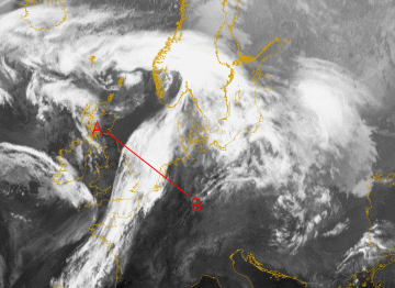
Cloud structure in satellite images
Satellite images show at least an amplification of the cloud bulge and a retardation of the propagation of the wave along the frontal cloud band (i.e. the Wave becomes "slower"). The character of the cloud bulge is then similar to a "classic" Wave, but there is no further development of the Wave bulge.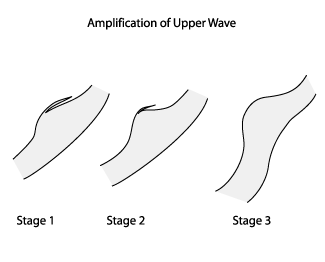
Meteorological Physical Background
Though the case of 16 March 2005 shows a distinct amplification of the Wave bulge during its lifecycle, the Upper Wave is still dominated by upper relative streams. The limiting streamline between the Upper Relative Stream (u.r.s.) and the Warm Conveyor Belt (w.c.b.) is situated far in front (see schematic below).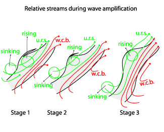
|
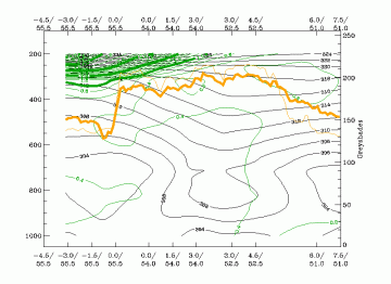
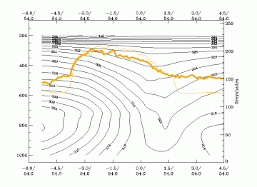
16 March 2005/18.00 UTC - Vertical cross section; black: isentropes (ThetaE), orange thin: IR pixel values, orange thick: WV pixel values
|
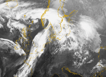
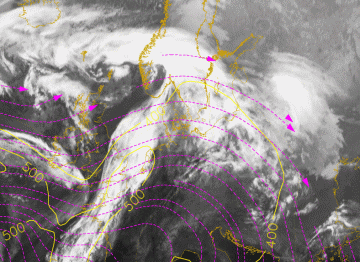
16 March 2005/18.00 UTC - Meteosat 8 IR 10.8 image; magenta: relative streams 312K, yellow: isobars; position of vertical cross section indicated
|
|
|
Key Parameters
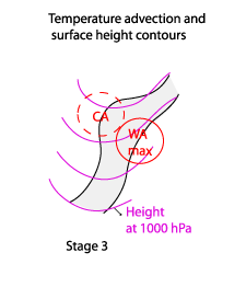
The most important parameters to distinguish between an Upper Wave and a Wave are the height contours at 1000 hPa and the temperature advection field at 700 hPa. By 17 March 2005 at 12.00 UTC a flat surface trough connected to the Cold Front can be seen over the cloud band. No distinct separate surface low has yet developed in the region of the Wave bulge of the Upper Wave over Estonia, although the Wave bulge has amplified significantly during the life cycle (seen in the IR10.8 loops above). A maximum of temperature advection is observed in the vicinity of the cloud bulge, but the Wave bulge itself is still under cold advection (see schematic and image below).|
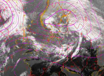
17 March 2005/12.00 UTC - Meteosat 8 IR 10.8 image; red: temperature advection 700 hPa; magenta: height contours 1000 hPa
|
|
|
|
Typical appearance in vertical cross section
Usually the parameters do not change much during the life cycle of an Upper Wave but, as mentioned before, single parameters show a tendency to develop Wave - like characteristics. If there is an amplification of an Upper Wave, the PV=1 unit, which can only be seen initially at levels higher than 500 hPa, will expand down to lower levels. In most of the cases a single maximum of PV=0.8 units develops at middle levels. This resembles the appearance of potential vorticity associated with a classic Wave, but the PV values are much less than those within a maximum of potential vorticity in a "classic" Wave.The case of 16 March 2005 shows such a development. In the IR10.8 image loop below the vertical cross sections for each time step (6 hours) are indicated.
16 March 2005/18.00 UTC - Meteosat 8 IR 10.8 image; position of vertical cross section indicated
16 March 2005/18.00 UTC - Vertical cross section; black: isentropes (ThetaE), dark green thin: potential vorticity <1 unit, dark green thick:
potential vorticity >=1 unit, orange thin: IR pixel values, orange thick: WV pixel values