Foehn - Meteorological Physical Background
by ZAMG
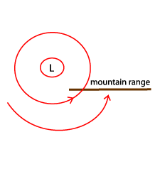
The basic condition leading to a Foehn process is a flow perpendicular to a mountain range. Regardless of the orientation of the mountain chain (W-E or N-S) an intensive low to the W, NW of this mountain chain is the basic synoptic-scale pre-condition for such a perpendicular stream. Reaching the mountain chains the air is forced to rise. Initially the cooling of the air mass is dry-adiabatic (1°C/100 m) until saturation is reached. Condensation begins and from then on the cooling is at the moist adiabatic lapse rate which is 0.65°C/100 m. At the height of the mountain tops the air mass will have lost much of its humidity content and can now be regarded as relatively dry. The sinking on the other side of the mountains and associated warming therefore takes place with the dry-adiabatic lapse rate. Consequently the air warms up during descent at a rate higher than the cooling during ascent and reaches the plains as a very dry, very warm and very strong wind - the Foehn.
|

|
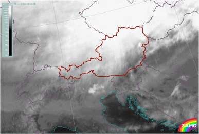
A mountain range for which these conditions are very well fulfilled are the Alps: if there is an intensive low in the W to NW of the Alps, a southerly stream reaches the Alpine mountain chain after it has overflow the Mediterranean Sea and therefore has the possibility to gain high values of humidity. Stau Cloud and rain develops to the south of the Alps; taking into account the height of mountains - up to about 3500 - 4000m - there is enough ascent to condense out the humidity content and to produce a very dry, warm Föhn-storm north of the Alps. This Foehn is called the S-Foehn (or Süd Foehn e.g. South Foehn) and usually reaches strengths of 100 km/h.
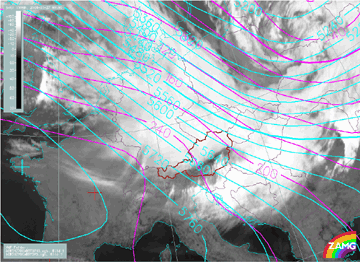
Whether the Foehn-storm is noticed as far down as in the valleys on the lee side of the mountains also depends upon the structure of the local boundary layer. If there is a mixed boundary layer, the Foehn will penetrate down to the lowest levels. If there is a boundary layer with a strong inversion it will not be able to reach the ground. In the satellite images a small black (cloud free) area can be seen moving eastward; it can be regarded as sign of such a breakthrough of the Foehn.