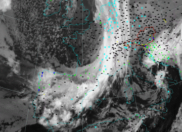
Split Front - Weather Events

by ZAMG and FMI


Weather events are highly variable and have to be split into two parts: the upper level front and the shallow moist area.

Upper Front

Parameter Description
Precipitation
  • Moderate to heavy showery precipitation
  • Quite often thunderstorms are observed.
Temperature
  • No significant change
Wind (incl. gusts)
  • Around embedded Cb's strong gusts are possible.
Other relevant information
  • The upper front at the transition between high and low cloud part
  • Hail and thunderstorms possible during whole year
  • Risk of moderate to severe icing and turbulence

Shallow moist area, including the surface front

Parameter Description
Precipitation
  • Slight to moderate rain or drizzle
Temperature
  • Falls after the passage of the surface front
Wind (incl. gusts)
  • Veering of the wind at the front passage
Other relevant information
  • Precipitation in area of shallow moist zone behind upper front
  • Risk of moderate icing
  • With superimposed PVA-max showers and thunderstorms are possible.
  • With showers moderate to severe icing and turbulence
28 December 2004/12.00 UTC - Meteosat 8 IR 10.8 image; weather events (green: rain and showers, blue: drizzle, cyan: snow, red: thunderstorm with precipitation, purple: freezing rain, orange: hail, black: no actual precipitation or thunderstorm with precipitation);

Menu Of Split Front
Typical Appearance In Vertical Cross Sections
References