Cold Front - Special Investigation: Convective Weather Events Within Or At The Rear Of Frontal Cloud Bands
by KNMI
A frontal zone seen in the satellite image can sometimes deviate from the ideal configuration of a smooth, layered cloud
band. This is particularly the case within the cloud band of a Cold Front, but it sometimes also occurs within Occlusions. In such cases the cloud band has a more lumpy characteristic and the tops of embedded Cbs are very distinct in all channels. The reason for this phenomenon is enhanced convection. In most cases the frontal Jet has a distinct component normal to the frontal zone. Convection is enhanced either by PVA in the left exit of the jet streak (see FI by jet) or, when the jet is more or less perpendicular to the front, through a combination of potential instability and frontal convergence (see Split Front). There are also cases in which the jet is parallel to the frontal cloud band, but there is also strong convection within the frontal zone.
|
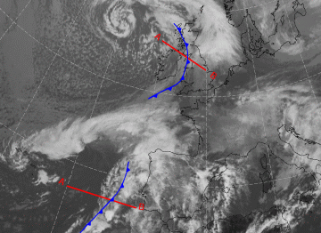
19 Ocotber 2004/12.00 UTC - Meteosat ch10.6 image; position of vertical cross sections indicated
|
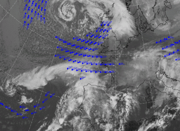
19 Ocotber 2004/12.00 UTC - Meteosat ch10.6 image; blue: wind 300 hPa
|
|
|
|
Investigations were made of 50 Cold Fronts, 25 of the layered type and 25 of the convective type, as detected from the Satellite image. The period covered the four seasons of the year from September 2003 till October 2004. Ten parameters where examined included the key parameters of all types of described Cold Front in the SatRep Manual. Statistical difference significance was only found with the humidity in the higher levels, and in the instability index (Boyden). In the case of a convective front, the 500 hPa humidity had a significantly lower value than the humidity in a more layered, smooth Cold Front. In a convective Cold Front the main value of the Boyden Index was above 95 which means high risk of thunderstorms, whilst in layered fronts the main value was around 94 which is below the threshold value for risk of thunderstorms. The convective Cold Fronts tends to be more of the Kata type. Marked differences with season were not found.
|
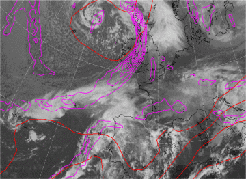
19 Ocotber 2004/12.00 UTC - Meteosat ch10.6 image; red: Boyden index, cyan: TFP
|
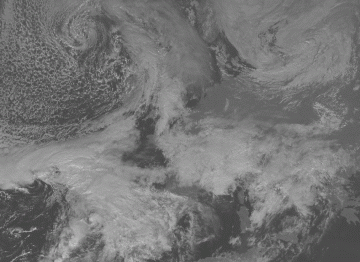
19 Ocotber 2004/12.00 UTC - HRSEVIS image
|
|
|
|
The most distinct difference (see image above left) between a convective and a non convective Cold Front is seen in the
combination of instability index with the thermal front parameter. In the case of a convective Cold Front, high values of the instability index lie within the maximum of TFP, whilst in a layered Cold Front, high values of instability index are found behind the TFP, and further away from the Cold Front, in the cold air.
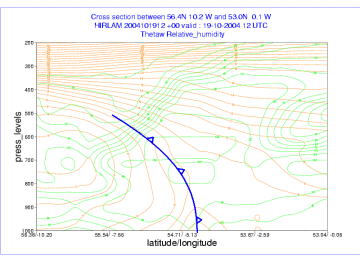
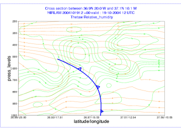
The physical explanation of the differences between the two front types has to be found in the differentiation between instability in the lower parts of the troposphere and the potential instability. In the case of a convective front, the values of both are much higher than within a layered Cold Front. The Cross Sections below show this clearly. The convective front (left) has a strong potential instability up to 700 hPa, over a broad zone, while the layered front (right) only has weak potential instability up to 800 hPa.
The cross section on the left is of the convective front, west of Portugal, and the one on the right is through the layered Cold Front over the British Isles.
|
19 Ocotber 2004/12.00 UTC - Vertical cross section; green: relative humidity, ochre: wet bulb temperature (ThetaW)
|
19 Ocotber 2004/12.00 UTC - Vertical cross section; ochre: wet bulb temperature (ThetaW)
|
|
|
|