Cumulonimbus (Cb) And Mesoscale Convective System (MCS) - Special Investigation: The Train Effect Or Train Mechanism
by IM
Introduction
A special case of convective development is the so-called train effect or train mechanism, in which many intense convective cells form over the same place in a short period of time. This regime produces large amounts of rainfall, therefore being frequently related to flash flood events.
Meteorological Physical Background
The key for understanding why convective systems may produce large precipitation amounts over a certain place is determined by comparing the system motion with the system structure as explained below.
|
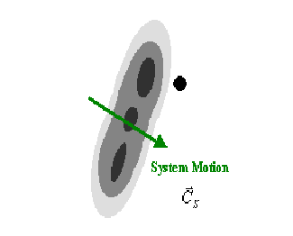
Consider a convective line structure (shades indicate radar reflectivity) moving across a specific location (circle) with a motion (
 ) nearly normal to the line.
|
|
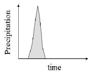
The total rainfall amount at the referred location (shaded area in the graphic) is relatively small. |
|
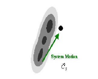
Now consider the same line structure, passing over the same location, but with its motion with a small normal component to the convective line. In this case the single convective structures embedded in the line will consecutively pass over the same spot. |
|
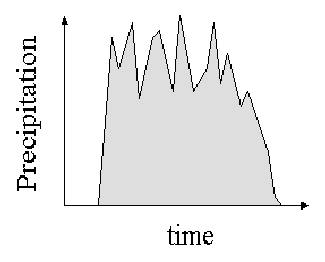
Precipitation plot will reflect this feature, showing consecutive peaks of precipitation during a longer period, therefore with large amounts of total precipitation. |
|
Adapted from Doswell et al (1996).
|
|
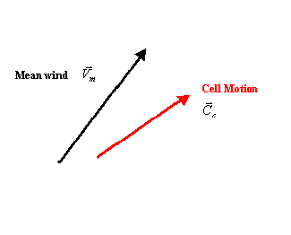
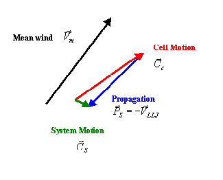
Cell Motion
Cell motion (
 ) is generally related to the mean wind in a certain tropospheric layer in which cloud systems are embedded. In the example below, cell motion vector is to the right of mean wind vector, which therefore classifies the cell as a right mover. Some studies for MCS and MCC show that cell motion has a higher correlation with wind at 700 hPa.

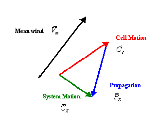
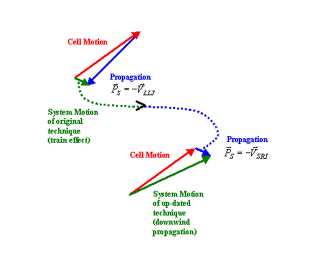
Propagation of the system and System Motion
At the end, system motion is what matters to define small or large precipitation amounts in a specific location. System motion (
) results from combining cell motion (
) with the propagation of the system as a whole defined by vector
 .
.

|
If the propagation vector
differs considerably in azimuth from cell motion
(as shown left), then the system motion vector
acts in such a way that the system moves to its right during the life-time, affecting different areas.
|
|
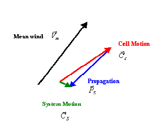
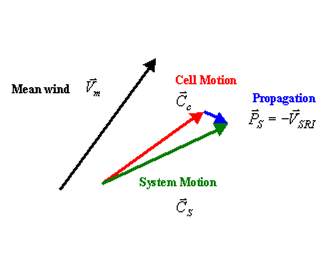
On the other hand, if the propagation vector
practically off-sets cell motion
(that is, it has almost the same intensity but an opposite direction), then system motion vector
is such that the system can be considered quasi-stationary.
|
|
Adapted from Corfidi et al (1996) and Doswell et al (1996).
|
|
|
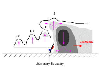
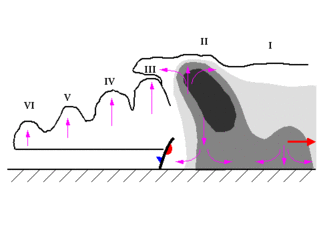
Step 1 - Cell I is forming over the position of a low level outflow boundary (plotted for the sake of simplicity as a stationary front) with a strong updraft above and divergence in the upper troposphere. |
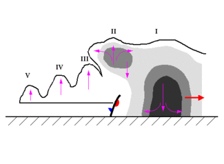
|
Step 2 - Cell I is moving eastward and cell II is now forming over the same stationary boundary. The outflow from cell I interacts positively, reinforcing the updraft of cell II |
|
Step 3 - A third cell (cell III) is now building over the same location, but this time at the expense of cell II outflow. This confirms a westward propagation with eastward cell motion, resulting in a train effect. |
|
Adapted from Doswell et al (1996); grey shades represent radar reflectivities of 10, 30 and 50 dBZ).
|
|
From stated above, it is easy to conclude that knowing the propagation vector in an operational basis would be the key tool to detect quasi-stationary convective systems, that is, to forecast heavy rainfall and the probability of occurrence of flash flood events. Unfortunately, the determination of the propagation vector is still not completely clear. Corfidi et al (1996) suggested that the speed and direction of the low-level jet (LLJ) could be indicative of the propagation.

In latter studies, Corfidi (1998, 2003) updates the results referring that propagation for MCS does not necessarily occurs most rapidly in the direction of the LLJ, but rather in the direction of the largest system relative low-level convergence - this direction may or may not be the direction of the LLJ.
In the second case, when convergence is maximized in a direction away from the LLJ (for instance due to the existence of gust fronts under conditionally unstable environments), the system motion can be very different from the one predicted by the original technique. In this up-dated technique, the propagation vector
may be called Storm Relative Inflow (SRI) vector. The resulting system motion
can be very large (downwind propagation), therefore not fitting a train effect scenario.
Finally, note that the mechanism of training has also been found to happen in systems similar in nature to a MCS but that do not meet the size criteria; these systems, referred to as sub-MCS, are related to moderate precipitation events (Saarikale, 2009).
Cloud Structure in Satellite Images
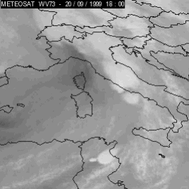
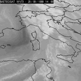
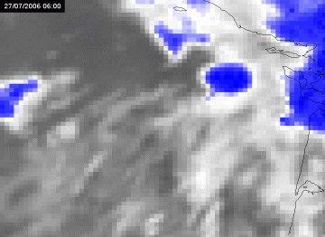
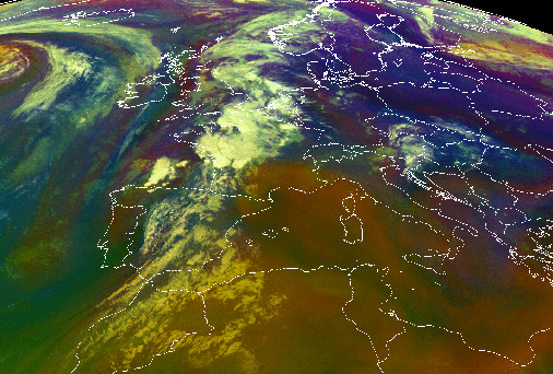
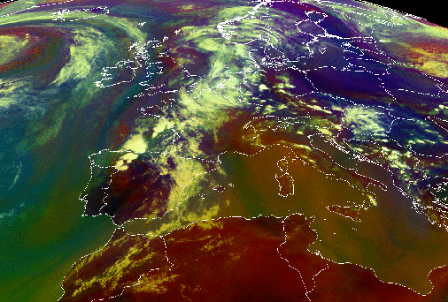
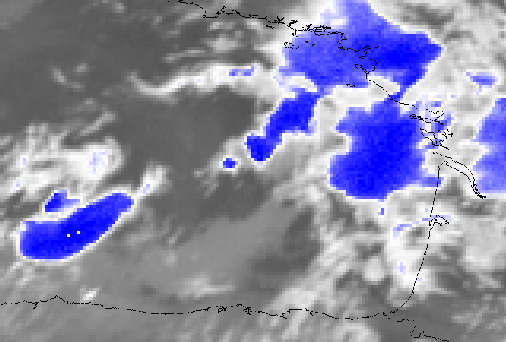
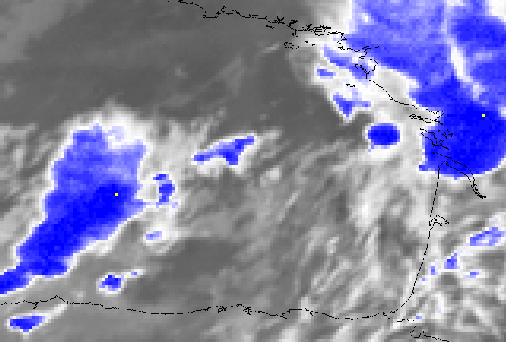
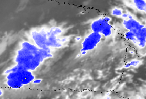
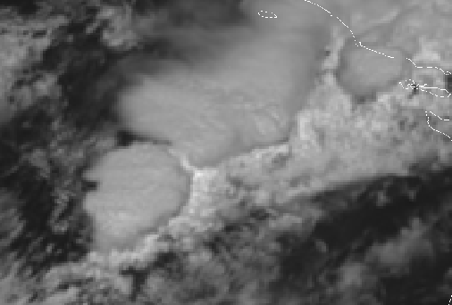
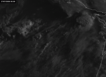
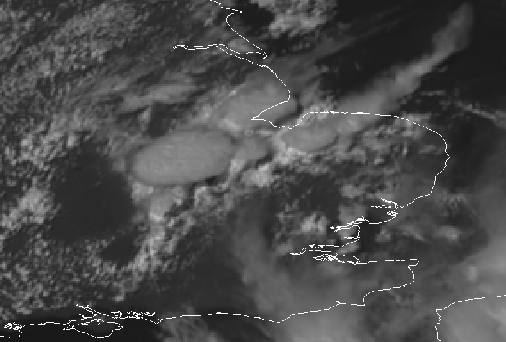
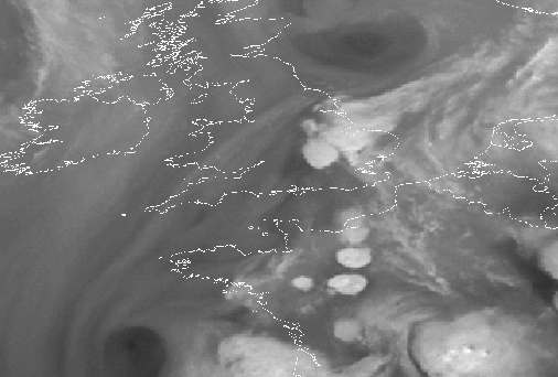
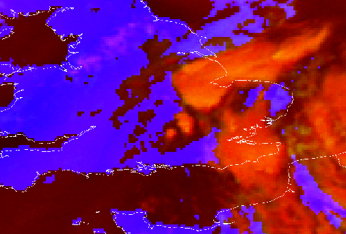
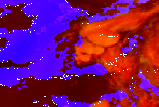
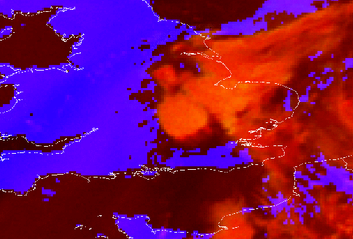
Train effect is clearly seen in satellite images making use of animations of several hours. In the animation shown below (left) for an event on 20 September 1999, the 30 minutes time resolution WV channel of Meteosat 7 can be followed between 02.00 UTC and 18.00 UTC. During the 16 hours you can see the convective area as whole moving southeastwards, with many convective systems forming over the Tyrrhenian sea.|
20 September 1999/18.00 UTC - Meteosat 7 WV image
|
20 September 1999/14.00 UTC - Meteosat 7 WV image
|
|
|
|
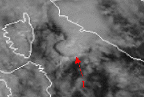
20 September 1999/10.00 UTC - Meteosat 7 VIS Image
|
20 September 1999/11.30 UTC Meteosat 7 VIS Image
|
|
|
Key Parameters
Note that in many studies the synthesis of key parameters for large-scale patterns or vertical profiles are simply summarized for flash flood events, with no special focus on the train effect. Although, this special investigation is being focused on the train effect, the following description broadens the scope of analysis for operational application, taking into consideration that according to Doswell et al (1996) virtually all flash floods are produced by MCSs.Also note that train effect results generally in the production of some convective systems over the same area for up to around 4-5 hours. In a longer range (10-12 hours) the area where the train effect occurs usually tends to move slowly southeastward, starting to affect neighboring areas, as shown above. Therefore, key parameters in model analysis with 6 hours difference can very often depict slightly different affected areas.
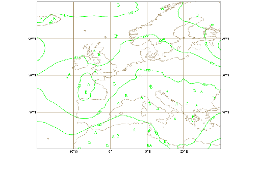
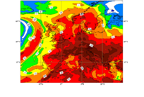
850-500 hPa Thickness Diffluence
The major convective rainfall events are generally found in areas of diffluence of the thickness parameter, which determine regions of low-level convergence or upper-level diffluence. Naturally this is a large-scale parameter and provides a general indication of the location for convection. If the pattern of thickness diffluence remains relatively stationary with time, the possibility for train effect should be in the forecaster�s mind and included in his/her nowcasting activities with satellite or radar imagery.
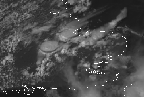
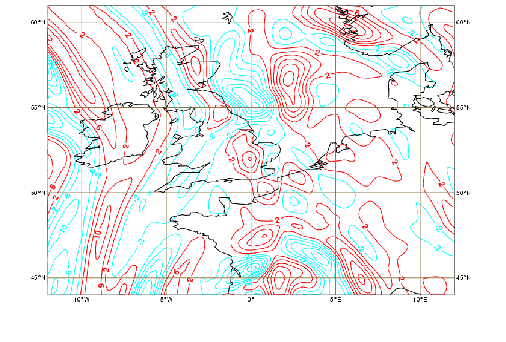
The case below shows diffluence and convective activity in the air mass RGB in northern Spain, Gulf of Biscay, France and southern UK at 06 and 12 UTC on 27 July 2006.
|
27 July 2006/06.00 UTC - 500-850 hPa Thickness
|
27 July 2006/12.00 UTC - 500-850 hPa Thickness
|
|
|
|
|
|
27 July 2006/06.00 UTC - Meteosat 8 air mass RGB (WV6.2-WV7.3; IR9.7-IR10.8; WV6.2i) image
|
27 July 2006/12.00 UTC - Meteosat 8 air mass RGB (WV6.2-WV7.3; IR9.7-IR10.8; WV6.2i) image
|
850hPa Wet Bulb Potential Temperature (Theta W)
Many train effect cases with potential for flash floods happen in "warm" months, within the influence of tropical air masses, both over a ridge or close to a gradient of the wet bulb potential temperature field. This last situation also fits some train effect cases happening during "cold" months. The example presented above shows both cases:
Case 1:
|
27 July 2006/06.00 UTC - Wet Bulb Potential Temperature 850 hPa
|
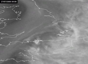
27 July 2006/03.00 UTC Meteosat 8 IR10.8-WV6.2 difference image (overshooting tops in yellow)
|
|
|
|
|
|
27 July 2006/06.00 UTC Meteosat 8 IR10.8-WV6.2 difference image (overshooting tops in yellow)
|
27 July 2006/09.00 UTC Meteosat 8 IR10.8-WV6.2 difference image (overshooting tops in yellow)
|
|
27 July 2006/10.15 UTC - Meteosat 8 HRV image
|
27 July 2006/12.15 UTC - Meteosat 8 HRV image
|
|
|
|

|
|
27 July 2006/06.00 UTC - Meteosat 8 HRV image
|
27 July 2006/06.00 UTC - Meteosat 8 IR10.8-WV6.2 difference image (overshooting tops in yellow or red)
|
Case 2:
From midday onwards during the same day, a formation of different convective systems over south UK, in an area between Leicester, Oxford and Cambridge, also fitted the train effect, but in this case a ridge (check the 18°C isotherm) is stretching from France into the UK.
|
27 July 2006/12.00 UTC - Wet Bulb Potential Temperature 850 hPa
|
|
|
|
|
|
|
27 July 2006/13.45 UTC Meteosat 8 HRV image
|
27 July 2006/14.30 UTC Meteosat 8 HRV image
|
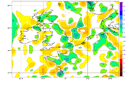
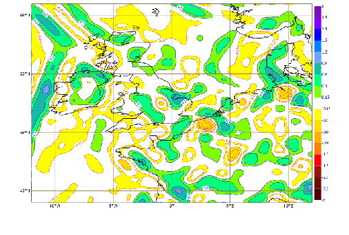
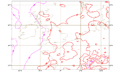
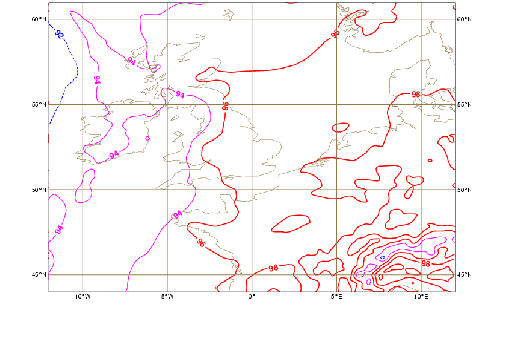
Specific humidity convergence at 1000 hPa
An important key parameter to consider from NWP outputs is the specific humidity convergence at 1000 hPa, which shall have local maxima in the train area. It might be expected that this field depicts other local maxima where the forecaster on duty sees no convective development. Naturally, it is a nowcasting task for the forecaster to find which model proposals for convection are likely to develop in the near future, also taking into consideration expected deviations between the atmospheric models and the atmosphere itself.
Naturally, if only convergence at 1000 hPa is available (and not specific humidity convergence), this can also be an alert, but note that moisture inflow is in fact one of the main ingredients to convection.
|
27 July 2006/12.00 UTC - Specific Humidity Convergence 1000 hPa (in 10^-5 g/Kg/s). Greenish and bluish colors represent humidity
convergence; yellowish and reddish colors represent humidity divergence.
|
27 July 2006/18.00 UTC - Specific Humidity Convergence 1000 hPa (in 10^-5 g/Kg/s). Greenish and bluish colors represent humidity convergence;
yellowish and reddish colors represent humidity divergence.
|
|
|
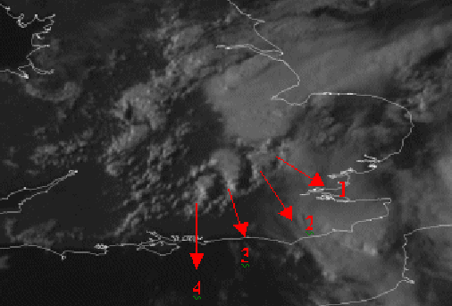
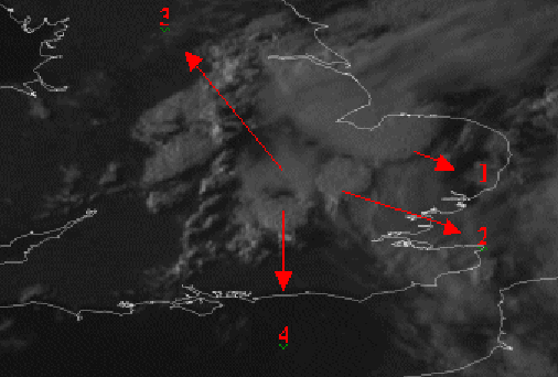
- position of cell 2 (fully developed) at 17.00 UTC is over position of cell 1 (first stage) at 16.00 UTC
- position of cell 4 (fully developed) at 17.00 UTC is over position of cell 3 (first stage) at 16.00 UTC
|
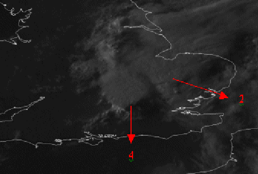
27 July 2006/16.00 UTC - Meteosat 8 HRV image. Individual cells numbered from 1 to 4
|
27 July 2006/17.00 UTC Meteosat 8 HRV image. Individual cells numbered from 1 to 4
|
|
|
|
|
|
27 July 2006/18.00 UTC Meteosat 8 HRV image. Only cells 2 and 4 are identifiable.
|
Vorticity Advection at 300hPa
Vorticity advection at 300 hPa has also been found to show areas of local maxima around the spot for successive convection. It should be noted, however, that these maxima may not be in a clear relation to an upper-level jet or strong tropopause anomalies, but rather related to weak tropopause anomalies (see similarities with the conceptual model Enhancement of convection by PV, Convective Cloud Features In Typical Synoptic Environments: Enhancement of convection by PV ). Again, like for specific humidity convergence, other local maxima may be present. Therefore, nowcasting will help finding the first convective bursts and check if there is or not stationarity of the systems.
|
27 July 2006/18.00 UTC - Vorticity Advection 300 hPa
|
27 July 2006/18.00 UTC - Meteosat 8 WV6.2 image
|
|
|
|
|
|
27 July 2006/09.00 UTC - Meteosat 8 WV6.2 image
|
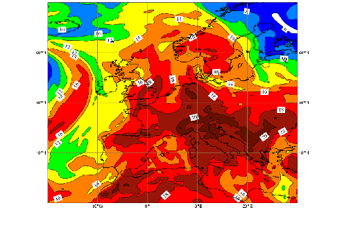
Instability (Boyden Index)
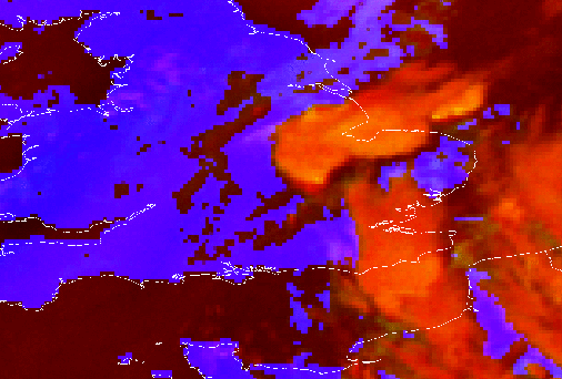
Finally one more obvious condition, which could even be firstly considered, is stability. In this case, the Boyden index is presented, whose threshold for risk of thunderstorm can be set to 95. Note, that one should not need to have the largest values in the area of train effect. In these instants, larger values are reached in Continental Europe, where convection also developed, but not so much fitting to train effect. The convective activity during the afternoon is shown with the deep convection RGB.|
27 July 2006/12.00 UTC - Boyden Index
|
27 July 2006/18.00 UTC - Boyden Index
|
|
|
|
27 July 2006/15.15 UTC - Meteosat 8 Deep Convection RGB (WV6.2-WV7.3; IR3.9-IR10.8; NIR1.6-VIS0.6) image
|
27 July 2006/16.00 UTC - Meteosat 8 Deep Convection RGB (WV6.2-WV7.3; IR3.9-IR10.8; NIR1.6-VIS0.6) image
|
|
|
|
|
|
27 July 2006/17.00 UTC - Meteosat 8 Deep Convection RGB (WV6.2-WV7.3; IR3.9-IR10.8; NIR1.6-VIS0.6) image
|
27 July 2006/18.00 UTC - Meteosat 8 Deep Convection RGB (WV6.2-WV7.3; IR3.9-IR10.8; NIR1.6-VIS0.6) image
|
Low-Level Jet and Veering
As seen in the Meteorological Physical Background, the propagation of the convective system may or not be related to a LLJ. In the case where a train effect event is dynamically related to a LLJ, one operational challenge for a forecaster is to identify its existence, whether using model forecasts or observational data from radio soundings or radar. On one side, the model may not reproduce the LLJ and, on the other side, the LLJ position/intensity may not be observed due to a sparse resolution of radio sounding and radar networks for the analysis of this phenomenon.For the analyzed case on 27 July 2006, the model does not detect any indication of a LLJ in the vicinity of the area of train effect (a LLJ was considered to have an intensity of 20kt or more in some layer above surface and below 850 hPa). Following the previous considerations, either the LLJ was not dynamically important or it was but it was not correctly modeled.
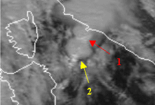
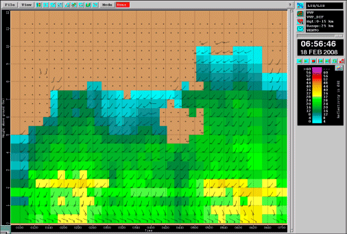
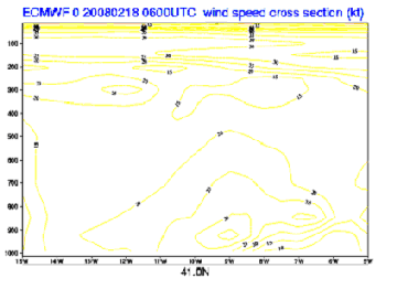
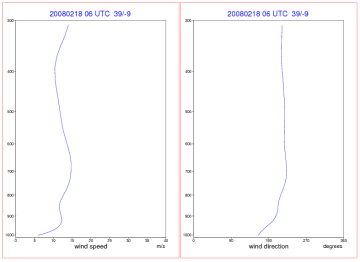
However, for the Lisbon case shown in the satellite image chapter, a LLJ was found both by model and radar in the vicinity of the affected areas. In the radar vertical profile sequence shown below, wind speeds of 35-40kt at a height of approximately 1000m were measured for several hours during the event, with a persistence veering of the wind from SE to SW in the first two km. This was also an indication of warm air advection in the lower levels and, as a consequence, increasing instability.
|
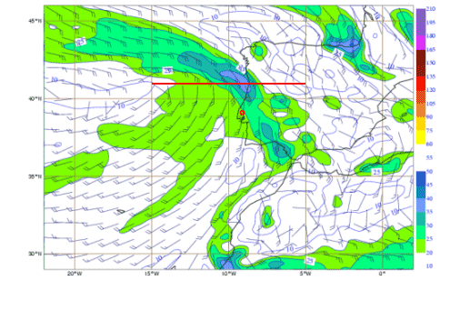
18 February 2008/06.00 UTC - Wind barbs and isotachs 925 hPa (red line for cross section and red circle for vertical profile location)
|
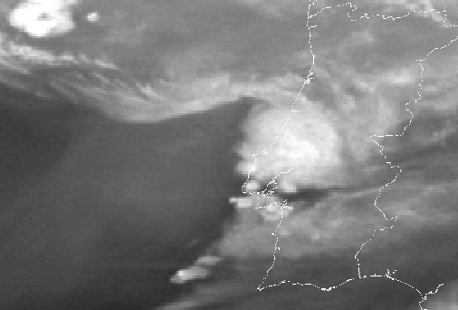
18 February 2008/06.00 UTC - Meteosat 9 WV image WV 6.2 image
|
|
|
|
|
|
18 February 2008/06.00 UTC - Vertical cross section; yellow: isotachs
|
18 February 2008/06.00 UTC - Vertical profile; left: wind speed; right: wind direction
|
Final Note
This Special Investigation started with a preliminary evaluation of around 100 cases of convective systems over Europe between 1992 and 2009 with both Meteosat first and second generation satellites. These cases were previously studied under the scope of EUMETSAT and EUMETRAIN activities. After excluding orographic induced convection, a total of 7 cases of clear visual train effect were explored in detail; 3 of these cases are presented here.
References
- AEMET, 1999: Modelos conceptuales a mesoscala. Sistemas Convectivos de Mesoscala. Biblioteca de Modulos TEMPO. Version 2.0. April (in spanish).
- COMET Activities at Saint Louis University - http://www.eas.slu.edu/Comet/precip.html
- CORFIDI S. F., MERRIT J. H. and FRITSCH J. M., 1996: Predicting the movement of Mesoscale Convective Complexes. Weather and Forecasting, 11, 41-46, March.
- CORFIDI S. F., 1998: Forecasting MCS mode and motion. 19th Conference Severe Local Storms, Minneapolis, MN.
- CORFIDI S. F., 2003: Cold Pools and MCS Propagation: Forecasting the Motion of Downwind-Developing MCSs. Weather and Forecasting, 18, 997-1017, December.
- DOSWELL III C. A., BROOKS H. E. and MADDOX R.A., 1996: Flash flood forecasting: An ingredients-based methodology. Weather and Forecasting, 11, 560-581, December.
- FUNK T. W., 1991: Forecasting Techniques Utilized by the Forecast Branch of the National Meteorological Center during a major convective rainfall event. Weather and Forecasting, 6, 548-564, December.
- HOUZE Jr R. A., SCHMID W., FOVELL R. G. and SCHIESSER H. H., 1993: Hailstorms in Switzerland: left movers, right movers, and false hooks. Mon. Wea. Rev., 121, 3345-3370, December.
- SAARIKALLE E., 2009: Heavy rain events in Finland 2000-2008. M.S. Thesis - Meteorology. University of Helsinki. Department of Physics.
