Convective Cloud Features In Typical Synoptic Environments: At The Leading Edge Of Frontal Cloud Bands - Typical Appearance In Vertical Cross Sections
by ZAMG
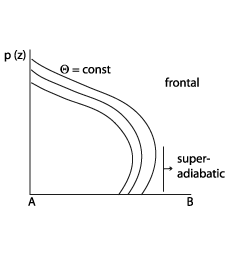
- Isentropes of equivalent potential temperature show an unstable stratified troposphere within the lower and mid-levels of the troposphere, which is mostly superadiabatic in the lower layers.
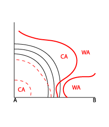
- The vertical distribution of temperature advection is characterised by CA at middle and higher levels indicating cold air overrunning the frontal air mass. This means that the stratification becomes unstable.
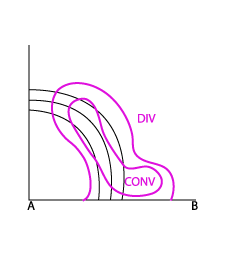
- Fields of divergence indicate convergence within the lower and mid-levels. In the case of pre frontal MCS development, the convergence is part of the frontal circulation cell and has a distinct pre frontal maximum, indicating strong ascending motion.
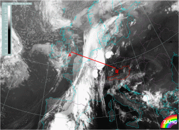
30 May 2005/00.00 UTC - Meteosat IR10.8 image; position of vertical cross section indicated
|
Vertical distribution of isentropes typical for development of MCS
|
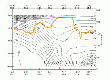
30 May 2005/00.00 UTC - Vertical cross section; black: isentropes (ThetaE), orange thin: IR pixel values, orange thick: WV pixel values
|
|
|
|
Vertical distribution of isentropes and temperature advection typical for development of MCS
|
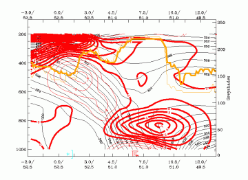
13 November 1997/00.00 UTC - Vertical cross section; black: isentropes (ThetaE), red thick: temperature advection - WA, red
thin: temperature advection, CA, orange thin: IR pixel values, orange thick: WV pixel values
|
|
|
|
Vertical distribution of isentropes and divergence typical for development of MCS
|
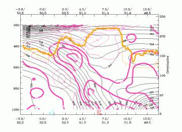
30 May 2005/00.00 UTC - Vertical cross section; black: isentropes (ThetaE), magenta thin: divergence, magenta thick: convergence, orange thin: IR
pixel values, orange thick: WV pixel values
|
|
|


