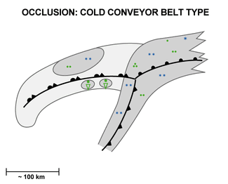
Occlusion: Cold Conveyor Belt Type - Special Investigation: T-Bone
by FMI
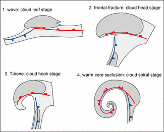
From satellite image and conceptual model points of view, the T-bone is a special case of a Cold Conveyor Belt Occlusion. Both start as a Wave in a baroclinic zone and end as an Occlusion. There are, however, significant differences in the stages in between. T-bones can also be seen as a type of Rapid Cyclogenesis (see Rapid Cyclogenesis ), because a deep surface low with strong winds and a typical cloud head development are observed. There is also a dissipation of cloudiness in the gap between the fronts due to the effect of a right exit region of a jet, which is similar to the conceptual model Front Decay (see Front Decay ). Also, because the Cold Front is weak at lower levels, T-bone has features similar to an upper Cold Front (see Cold Front ).
In this chapter two cases are compared: a Cold Conveyor Belt Occlusion 05 - 06 January 2003 and a T-bone 01 - 02 April 2001; the main differences are presented.
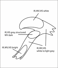
The T-bone development stages are presented in the following schematics:
Satellite Images
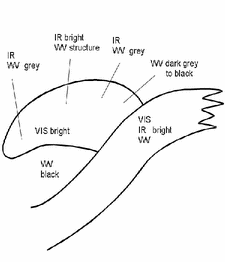
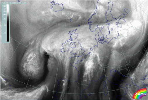
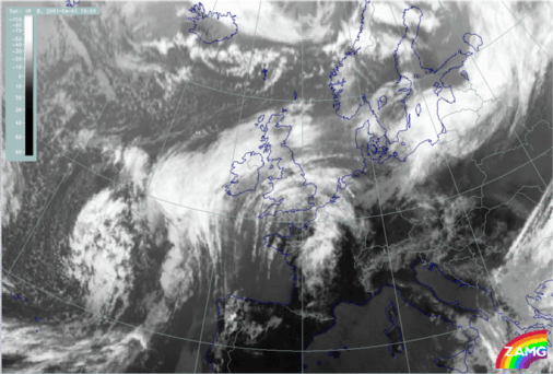
Appearance of a Cold Conveyor Belt Occlusion in satellite images:In IR images a lower cloud spiral gradually appears from below the higher cloud band. There is a dark area between Cold and Warm frontal cloudiness and the cloud head.
In WV images a Dark Stripe behind the Cold Front crosses the cold conveyor belt near the Occlusion point.
|
|
|
|
|
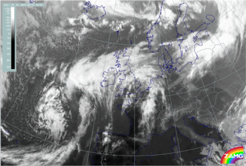
05 January 2003/18.00 UTC - Meteosat IR image
|
05 January 2003/18.00 UTC - Meteosat WV image
|
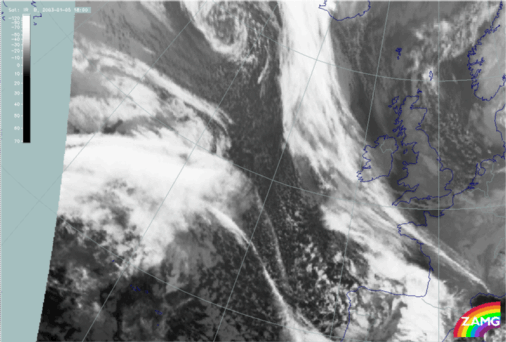
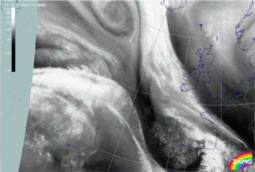
Appearance of a T-Bone in satellite images:
In tha IR images below, a weak lower cloud spiral seems to exist before the Occlusion. In the cloud head and cloud hook stages the cold frontal clouds clearly dissolve near the Warm Front due to the frontal fracture and the effect of the right exit area of the jet stream.
In the WV images below, there is a Dark Stripe behind the Cold Front, but it does not cross it as in the case of the Cold Conveyor Belt Occlusion. The Cold Front near the surface low is very dark grey in WV images.
|
|
|
|
|
01 April 2001/18.00 UTC - Meteosat IR image
|
01 April 2001/18.00 UTC - Meteosat WV image
|
The loop shows IR images from 05 January 12.00 UTC to 06 January 00.00 UTC. In the upper left corner there is a Wave that moves eastwards and develops into a Cold Conveyor Belt Occlusion, although there are also some features af Rapid Cyclogenesis present. The cloud head stage is reached on 05 January 18.00 UTC and the cloud hook stage on 06 January 00.00 UTC. The depression occludes on 06 January 00.00 UTC.
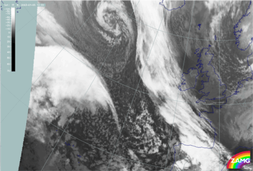
The loop below shows IR images from 01 April 15.00 UTC to 02 April 10.00 UTC. There is a Wave over the Atlantic that moves towars the British Isles and develops into a Warm Occlusion (for the of Occlusions see Meteorological Physical Background). The cloud head stage is reached at 18.00 UTC on 01 April and the cloud hook stage between 00.00 - 06.00 UTC on 02 April. By 02 April 12.00 UTC the depression has occluded.
Numerical Parameters
The height contours of 1000 and 500 hPa are similar in both cases: i.e. a rapidly deepening surface low with an upper trough to the west.Temperature advection is, likewise, similar: the Warm Front and the cloud head cloud systems are within warm advection in both cases.
Jet stream:
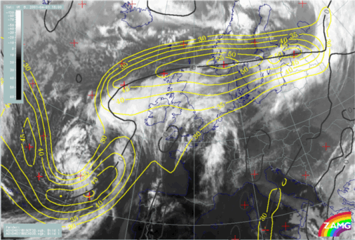
In the case of the Cold Conveyor Belt Occlusion there is a strong jet following the cyclonic edge of the frontal cloudiness. In the T-Bone, there are two jets: one ahead of the Warm Front and a second behind the Cold Front. In the frontal fracture stage they are separated, in the Occlusion stage the two jets merge.
Zero line of shear vorticity at 300 hPa:
In the Cold Conveyor Belt Occlusion the zero line of shear vorticity is a relatively straight line following the jet streak. In the T-Bone the zero line is curveed within the cloud head and cloud hook. The curve straightens somewhat in the Occlusion stage.
|
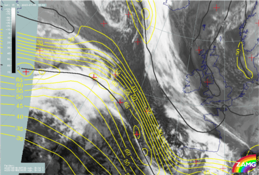
05 January 2003/18.00 UTC - Meteosat IR image; yellow: isotachs 300 hPa, black: zero line of shear vorticity 300
hPa
|
01 April 2001/18.00 UTC - Meteosat IR image; yellow: isotachs 300 hPa, black: zero line of shear vorticity 300
hPa
|
|
|
Vertical Cross Sections
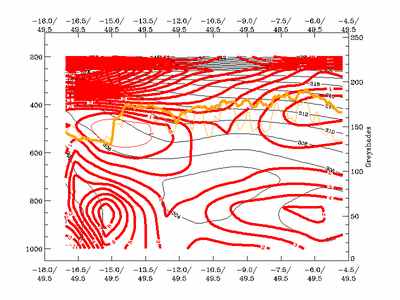
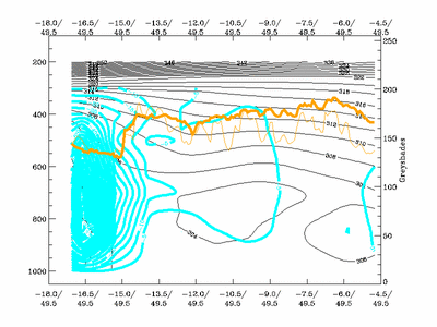
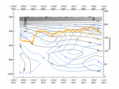
The cross sections below are taken during the cloud head stage. They show the properties of the partly dissolved Cold Front, which is the main difference between Cold Conveyor Belt Occlusion and a T-bone.The cross section is taken through the partly dissolved Cold Front near the surface low. The Cold Front is seen on the left, approximately in the area between longitudes 18W and 12W. The cross sections show:
- Weak Cold Front structure in the isentropes below 600 hPa between longitudes 18W and 16W with low IR and WV signals, and a weak upper Cold Front between 16W and 12W with higher IR and WV signals
- Warm advection in the area of Cold Front in the lower troposphere, very weak cold advection in the area of the upper Cold Front
- Very strong rising motion in the area of the front, not ahead and behind it as in a Cold Front (see Cold Front - Typical appearance in vertical cross sections )
- High humidity throughout the frontal zone
It can be concluded that although there is a weak cold frontal structure, the parameters do not fit a Cold Front.
|
01 April 2001/18.00 UTC - Meteosat IR image; position of vertical cross section indicated
|
01 April 2001/18.00 UTC - Vertical cross section; black: isentropes (ThetaE), red thick: temperature advection -
WA, red thin: temperature advection - CA, orange thin: IR pixel values, orange thick: WV pixel values
|
|
|
|
|
|
01 April 2001/18.00 UTC - Vertical cross section; black: isentropes (ThetaE), cyan thick: vertical motion
(omega) - upward motion, cyan thin: vertical motion (omega) - downward motion, orange thin: IR pixel values,
orange thick: WV pixel values
|
01 April 2001/18.00 UTC - Vertical cross section; black: isentropes (ThetaE), blue: relative humidity, orange
thin: IR pixel values, orange thick: WV pixel values
|
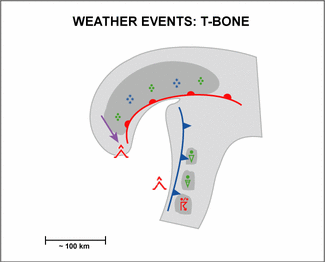
Weather Events
T-Bones are frontal structures that are usually associated with rapidly deepening lows. Heavy rain occurs ahead of the Warm Front, and stormy winds around its tail, especially in systems over the ocean. Contrary to a Cold Conveyor Belt Occlusion, there is no precipitation associated with the Cold Front located near to the Warm Front.
|
|
