BAROCLINIC BOUNDARY - CLOUD STRUCTURE IN SATELLITE IMAGES
by ZAMG
Appearance in Meteosat imagery:
In satellite images a Baroclinic Boundary is characterised by a cloud band which consists of low- and middle-level clouds with no significant cloud enhancement over time. High level cloudiness is only observed as cloud fibres associated with strong upper winds or a jet streak.- IR imagery:
- Dark to light grey low and middle level cloud band
- The Baroclinic Boundary usually appears darker (i.e. warmer cloud tops) than frontal cloud
- Sometimes a bright jet cloud fibre forms or fibre clouds are embedded within the cloudband
- WV imagery:
- The Baroclinic Boundary appears as a dark grey to grey cloud band with sometimes bright high fibres embedded
- The Baroclinic Boundary generally appears weaker in WV than a frontal cloud band
- VIS imagery:
- Depending on the type of cloud the VIS image shows low white patches or cloud bands. If existing, thin high cloud fibres appear grey.
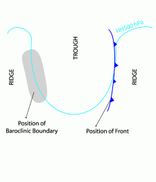
- At the rear of a synoptic scale trough (most frequent type, ~ 50 cases, schematic below left)
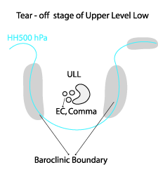
- Baroclinic Boundary associated with ULL (6 cases, schematic below middle)
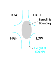
- Baroclinic Boundary associated with a deformation zone at a saddle point of upper height fields (3 cases, schematic below right)
|
|
|
At the rear of a synoptic scale trough
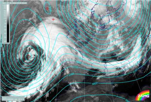
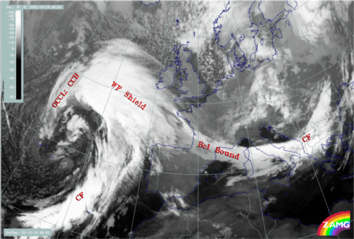
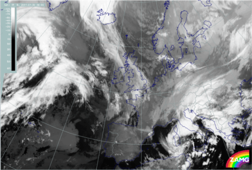
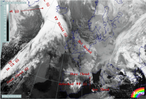
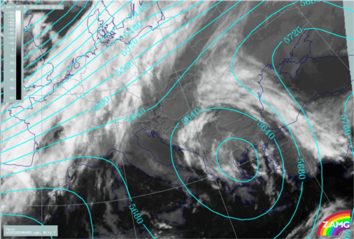
The set of images below shows a representative case of a Baroclinic Boundary at the rear of a synoptic scale trough extending from the Bay of Biscay to the Tyrrhenian Sea. The position at the rear of a synoptic scale trough is clearly indicated by the heights at 500hPa (below left).|
19 October 2002/06.00 UTC - Meteosat IR image; cyan: height contours 500 hPa
|
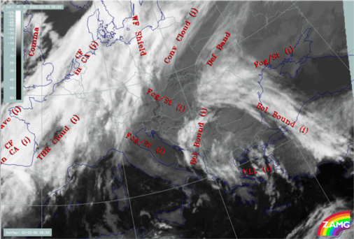
19 October 2002/06.00 UTC - Meteosat IR image; SatRep overlay: names of conceptual models
|
|
|
|
|
|
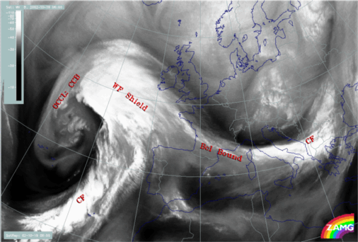
19 October 2002/06.00 UTC - Meteosat WV image; names of conceptual models
|
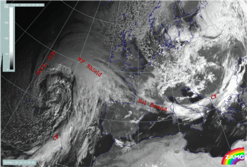
19 October 2002/09.00 UTC - Meteosat VIS image; names of conceptual models
|
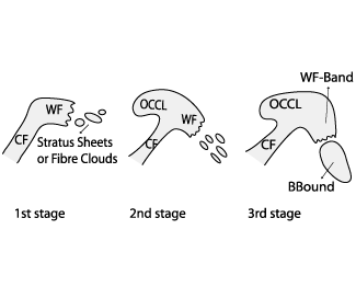
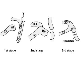
This type of Baroclinic Boundary can be distinguished as two types, according to development:
"In situ" development (~15 cases)
- Initially low clouds and Stratocumulus sheets exist, which are merging and intensifying (see schematics below, stage 1 - 3)
- Further development may show either dissipation of the Baroclinic Boundary or a merging with the succeeding frontal system
- The Baroclinic Boundary cloud band appears either as connected to a WF upstream and/or a CF downstream or can even be a separated cloud feature
|
18 October 2002/07.00 UTC - Meteosat IR image
|
|
|
|
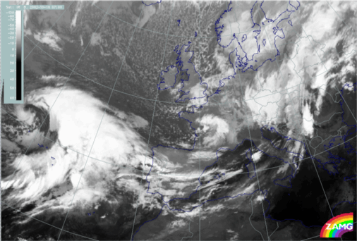
Modification of former frontal cloud (~ 35 cases)
The initiation of this type of Baroclinic Boundary is the modification of a former frontal zone. Such modifications have also been observed from former Occlusion (19 cases), from former elongating Cold Front (12 cases) and from former Warm Fronts or Detached Warm Fronts (4 cases).The schematics below (stage 1 - 3) outline a typical process: A new frontal system is appproaching the rear of a dissolving and/or elongating old cloud band. The old cloud system splits in two or more parts, where the northern part merges with the new system or is elongating and weakening. The southern part of the old cloud band redevelops to the rear of the trough in the gradient of equivalent thickness. The further development shows a general merging with the succeeding system or weakening and dissolution of the Baroclinic Boundary region.
The loop of the IR images shows an old system stretching from Great Britain to Iceland and a newly developed system over the Atlantic. In the loop the splitting of the old cloudband can be observed as well as the redevelopment and the positioning of the southern part at the rear of the upwind trough. The newly developed Baroclinic Boundary is finally positioned over Great Britain and northern France (image below right).
|
30 January 2001/06.00 UTC - Meteosat IR image
|
31 January 2001/06.00 UTC - Meteosat IR image; SatRep overlay: names of conceptual models
|
|
|
Baroclinic boundary associated with ULL
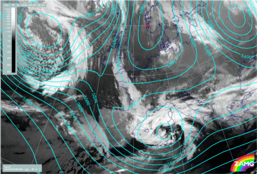
Synoptic scale cloud bands often appear to the rear of and at the leading edge of an Upper Level Low (see Upper Level Low ). They mostly consist of multilayered low and middle clouds and are cyclonically curved. Furthermore, a third zone with high baroclinicity is likely to appear at the north-easternmost part of the Upper Level Low ("Tear - off point"). This part is usually the remains of a former CF and shows as a highly deformed and elongated fibrous cloud band. According to its appearance this cloud band resembles that of the CM of the Deformation Band (see Deformation Band ).The two IR images below show a case of an Upper Level Low with two well developed Baroclinic Boundaries associated with it, and a Deformation Band near the Tear - off point. The centre of the Upper Level Low is situated over the Aegean Sea and Greece (see Height at 500 hPa, left image below).
|
05 February 2002/06.00 UTC - Meteosat IR image; cyan: height contours 500 hPa
|
05 February 2002/06.00 UTC - Meteosat IR image; SatRep overlay: names of conceptual models
|
|
|
Baroclinic Boundary associated with a deformation zone at a saddle point of upper height fields
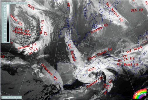
This type is the least common, and can be associated with a "cut - off" process within upper level troughs and ridges. Contrary to the other types described above, the Baroclinic Boundary exists in the frontogenetic/frontolytic areas at the saddle point of four pressure systems. Nearly all cases show a modification of former frontal cloud bands consisting of multilayered low and middle cloudiness which is elongating and gradually dissipating.The two IR images below show a Baroclinic Boundary within a characteristic deformation zone at the saddle point of height fields at 500 hPa (lower left image). It extends from S. France to Ireland and consists of low and middle level multilayered grey clouds. It can clearly be distinguished from all surrounding frontal cloud bands, by its brightness and curvature. The northern part of the old system from which the Baroclinic Boundary is now torn - off can still be seen in front of the trough north of Scotland.
|
04 April 2002/06.00 UTC - Meteosat IR image; cyan: height contours 500 hPa
|
04 April 2002/06.00 UTC - Meteosat IR image; SatRep overlay: names of conceptual models
|
|
|

