RELATIVE STREAMS
by ZAMG
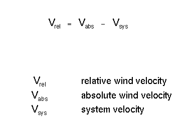
Relative streams are streams computed on isentropic surfaces where the potential temperature and/or the equivalent potential temperature is constant relative to a system velocity. This system velocity is subtracted from the absolute velocity:
The determination of the system velocity is one of the critical steps in the computation; it can be derived from the propagation of cloud systems accompanying a weather system. For instance the propagation of the frontal cloud band can be used for the system front and upper level trough.
The subtraction of the system velocity means that an observer would move with the system and that all the air streams and their changes occur relative to this system.
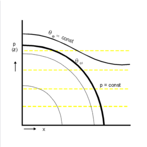
The next schematics explain the connection between presentations on isobaric and isentropic surfaces.
|
|
- The different air masses involved in a weather system are quasi-visualized through the relative streams which transport them; therefore sharp cloud boundaries and other cloud structures can be easily explained.
- An isentropic surface is a surface of constant potential (or equivalent potential) temperature, which means that air particles on such a surface do not undergo any heat exchange and consequently stay and move on this surface. Therefore rising and sinking can directly be seen on an isentropic surface by noting the isobars which are crossed by the streamlines.
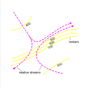
As already mentioned, the conveyor belt theory has been derived from such an approach. In the schematics above the typical conveyor belts associated with a Cold Front situation are marked. There is a Warm Conveyor Belt from the south-east bending to the north-east which transports warm and humid air and rises at the frontal surface (in the schematics from 700 to 500 hPa) and which is responsible for the development of the frontal cloudiness. A second main conveyor belt is called dry intrusion which is the relative stream from north-west bending to north-east which transports cold dry air and sinks till it reaches the highest level of the frontal surface (in the schematics from higher than 400 down to 500 hPa). At the boundary between both conveyor belts very often a sharp anticyclonically curved cloud boundary can be observed which is a consequence of the shape of the conveyor belts transporting different air masses; frontal lines mostly show a distinct cyclonic curvature, and at this point such a cloud shape cannot be explained so easily with conventional tools and ideas.
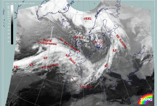
Warm Conveyor Belts and their associated cloudiness are not only involved directly in the frontal systems but appear frequently in the region of high fibrous cloudiness in front of cold fronts in the warm sector. The case study of 11 February 1997/06.00 UTC contains a good example in front of the Atlantic front. Also the conceptual model of the Rapid Cyclogenesis shows some distinct features in the relative streams. Both cloud systems can be used to demonstrate the use and interpretation of relative streams.
|
11 February 1997/06.00 UTC - Meteosat IR image; SatRep overlay: names of conceptual models, position of vertical cross section
indicated
|
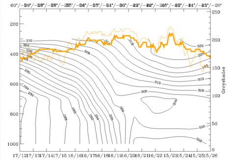
11 February 1997/06.00 UTC - Vertical cross section; black: isentropes (ThetaE), orange thin: IR pixel values, orange thick: WV pixel
values
|
|
|
|
|
|
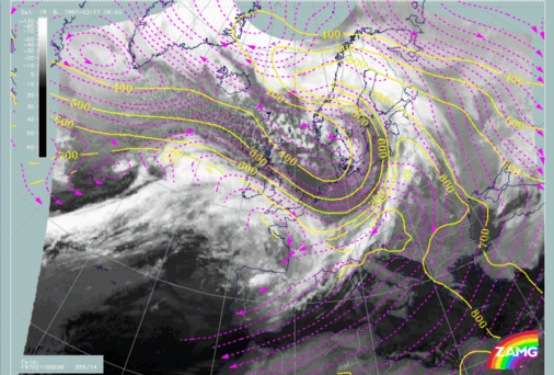
11 February 1997/06.00 UTC - Meteosat IR image; magenta: relative streams 308K - system velocity 259° 14m/s, yellow: isobars
|
11 February 1997/06.00 UTC - Meteosat IR image; magenta: relative streams 308K - system velocity 259° 14m/s, yellow: isobars
|
Relative streams within and north of the frontal cloud band clearly show a different origin from behind the Cold Front, therefore different air masses are approaching. Especially in the area of the Rapid Cyclogenesis a relative stream from north-west is involved in these height levels.
The low isentropic surface of 296K (right image) is representative of the situation in the area of the Rapid Cyclogenesis. It is a surface which is in the centre of the broad frontal zone and reaches the earth surface at grid point 16/18 which is approximately 52N/26W. There are two different relative streams involved: the one from the south rising sharply from the surface up to 550 hPa and bending to the east there; the second shows up as a small cyclonic circulation to the west in the area of the cloud spiral. Both represent a typical configuration for this conceptual model.

